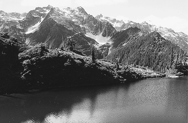
Mount Seattle rising beyond the larger of Martins Lakes
50 The North Fork of the Quinault
A 16.4-mile backpack from the North Fork Ranger Station to Low Divide.
Trail type: Primary.
Best season: All year.
Elevation gain: 3,776 feet.
Elevation loss: 676 feet.
Maximum elevation: 3,650 feet (Low Divide).
Topo maps: Bunch Lake, Kimta Peak, Mount Christie, Mount Hoquiam; Custom Correct Quinault–Colonel Bob.
Finding the trailhead: From U.S. Highway 101 at mile 125.5, turn east onto Lake Quinault South Shore Road. The pavement ends after 7.8 miles, and 5 miles later is a bridge over the Quinault. Turn left to cross it, and then turn right onto North Shore Road for the remaining 3.3 miles to the trailhead and ranger station at road’s end.
The Hike
This major valley-bottom route follows the North Fork of the Quinault to the Low Divide, where it meets the Elwha River Trail and a spur path to the alpine country around Martins Lakes. From the North Fork Ranger Station, the trail follows an old roadbed through a rain forest of great diversity. On drier sites enormous Sitka spruce and red cedar soar skyward. The flats of the floodplain are dominated by groves of slender red alders and pure stands of gnarled bigleaf maples draped with streamers of moss. The path runs level here, twice crossing a dry flood channel about 1.2 miles below Wolf Bar Camp. This camp is perched among tall alders and bushy clumps of sword fern beside the river.
The main trail soon works its way onto the hillside above the valley floor, and the surroundings begin to lose their rain forest aspect. Just after crossing Wild Rose Creek, the path descends onto another forested bottom, where it reaches the Halfway House camping area. This site was a rest stop for travelers on their way to the resort that once stood near the Low Divide. Although it does not appear on some maps, it is by far the most attractive campsite on the North Fork. A group site sits beneath a trailside grove of tall conifers, while others sites lie among the alders of the riverbank. At this point the river flows lazily through quiet pools between two opposing outcrops of metamorphic rock. On the far bank a waterfall splashes into its own tiny basin before joining the waters of the river.
The flats continue for a short distance beyond the camp, then give way to a series of forested finger ridges. The next campsite occupies the northern bank of Elip Creek in a ragged meadow beside the brushy stream bank. The trail passes this camp and then climbs onto the hillside beyond to reach a junction with the Elip Creek cutoff trail. The North Fork Trail continues north from this point, crossing a flat terrace covered with old-growth hemlocks. The level bench is scored with deep ravines containing the streams that descend from the west: Three Prune, Stalding, and Kimta. A sturdy pack bridge spans each cleft, and a scattering of western red cedar lends variety to the streamside timber.
Mount Seattle rising beyond the larger of Martins Lakes
Beyond Kimta Creek lies a boggy shelf of open forest and brush that contains the Trapper shelter and camping area. After crossing this bottomland, the trail climbs onto a hillside grown thickly with young hemlock. This is the site of an old forest fire, and silvery snags still rise from the younger trees on the hillside far above the trail. The path sticks to the steep slopes high above the river on its way to Twelvemile Camp, ascending in sporadic bursts. A number of nameless tributaries drop across the hillside and are bordered by loose gravel and open brushfields that allow ever-improving views of Mount Lawson on the far side of the river. The trail then leaves the dry hillsides to return to the lush forests of the floodplain. Here Twelvemile Camp and its shelter lie among groves of alders and tall hemlocks beside the river.
After a short hump over the intervening hillside, the trail descends to ford the river. The water can be 3 to 4 feet deep in May, but decreases to a moderate knee-deep flow in midsummer. A rope is usually in place across the river to help hikers with their balance as they cross. The Sixteen Mile Camp lies among the old-growth hemlocks of the far bank. It derives its name from the time before the road was built up the North Fork and travelers hiked in from the confluence of the two rivers. From this point the trail climbs steadily for a time then levels off after attaining a height several hundred feet above the river. The forest here is distinctly montane, with a less luxuriant undergrowth and fewer mosses and ferns. The trail ascends gradually for the next 3 miles, crossing a major torrent via a lofty pack bridge before returning to the forest.
The forest opens up as the trail crosses the headwaters of the river, and soon thereafter the Skyline Ridge Trail descends to the North Fork. A series of open meadows reveals the jagged buttresses of Mount Seattle to the west, with a silver skein of waterfall dropping down across the rock. Look back for a moment for a fine view of the nameless peak that stands sentinel over the headwaters of Promise Creek. The trail continues north as willows crowd the waterway. The ranger station occupies the former site of a mountain resort in the last meadow below the Low Divide itself. The campsites are spread throughout the opening at great distances from each other; check the map at the ranger station for their exact locations.
The trail then enters the trees for the rather anticlimactic final stroll to the top of the Low Divide. A parkland dotted with heather, shooting star, and yellow monkeyflower provides the setting for two quiet lakes. The larger one, Lake Margaret, is the first to be reached, while Lake Mary lies a short distance to the north. The Martins Lakes Trail departs from a signpost on the eastern shore of Lake Margaret.

Key Points
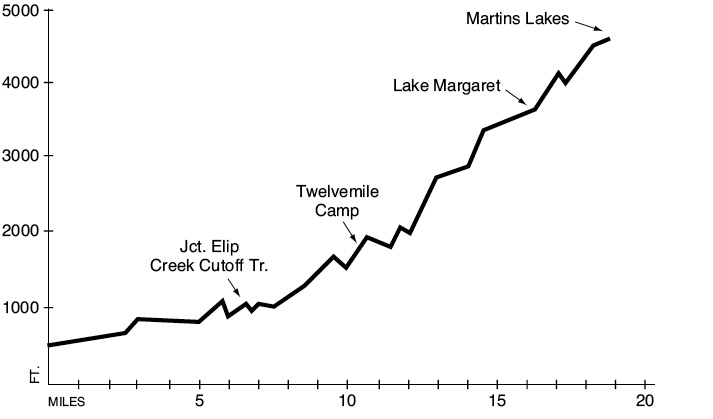
0.0Trailhead.
2.5Wolf Bar Camp.
4.9Trail crosses Wild Rose Creek.
5.1Halfway House Camp.
6.4Trail crosses Elip Creek. Elip Creek Camp.
6.5Junction with Elip Creek cutoff trail. Stay right.
6.8Trail crosses Three Prune Creek.
7.4Trail crosses Stalding Creek.
7.7Trail crosses Kimta Creek.
8.2Trapper Camp.
11.5Twelvemile Camp.
12.2Trail fords North Fork Quinault River. Sixteen Mile Camp.
15.7Trail crosses headwaters of North Fork Quinault River.
15.8Junction with Skyline Ridge Trail. Bear right.
16.0Low Divide Ranger Station and Camp.
16.3Trail crosses Low Divide.
16.4Lake Margaret. Junction with Elwha River and Martins Lakes Trails.
Martins Lakes Option: This primitive trail climbs into alpine country recently scoured by glaciers descending from Mount Christie. It offers a fine day trip for travelers of adventurous spirit who find themselves in the Low Divide area. It begins by running southeast through soggy country covered in a loose subalpine forest. After 0.5 mile of travel, the track comes to a dry ravine that runs between steep rock walls. The route follows the wash upward, and some scrambling is required. The path soon finds level ground again and proceeds southward. Martins Park is 1 mile into the trek, a broad expanse of wet meadow dotted with boulders brought down from Mount Christie by glaciers. The crags of this peak rise above the head of the steep rivulet that feeds the park.
The path soon finds its way into the valley of a rushing torrent that rises in the south. This stream is soon crossed, and the trail climbs steadily through the alder on its eastern bank. The upper basin of this stream lies 0.6 mile above Martins Park. Evidence of recent glaciation is everywhere: Moraines left by the retreating glacier lie across the valley floor, and patches of exposed bedrock bear deep grooves that were carved by the ice. Much of the valley floor has yet to be colonized by plants, retaining its primordial condition as bare stone and rubble. The trail soon climbs the meadowy slope opposite Mount Christie, whose spires and turrets cup the tiny vestiges of glaciers that once filled the entire basin. After a brisk ascent the trail doglegs back to the north and runs level to reach Martins Lakes. The first lake to be reached is shallow and aquamarine, while just beyond it lies the deeper tarn, a deep blue-green. The lakes occupy a lofty shelf that makes an excellent perch for viewing Mounts Seattle and Meany, which raise their rocky crests directly to the north.