54 The Hoh River
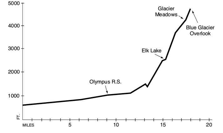
A 17.5-mile backpack from the Hoh Rainforest Visitor Center to Glacier Meadows, with an extra 0.6-mile hike to reach the Blue Glacier overlook.
Trail type: Primary to Martin Creek; foot beyond.
Best season: All year.
Elevation gain: 4,200 feet.
Elevation loss: 100 feet.
Maximum elevation: 4,700 feet (Blue Glacier overlook).
Topo maps: Mount Tom, Mount Olympus; Custom Correct Seven Lakes Basin–Hoh.
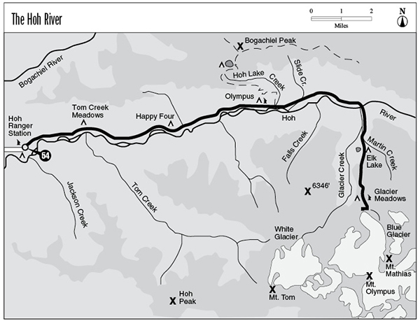
Finding the trailhead: From Forks, drive south on U.S. Highway 101 to mile 178.5. Turn east onto paved Hoh River Road. Drive 18 miles to the trailhead and visitor center at road’s end.
The Hike
This trail offers an outstanding sample of the diverse habitats of Olympic National Park, from primeval rain forests to windswept icefields. Its easy access makes it one of the most popular treks in the park, and travelers may want to schedule their visit here off-season to avoid the crowds. Permits are obtained at the Hoh Rainforest Visitor Center, although reservations are not currently required. Hoh is an adaptation of the Salish ohalet, meaning “white water.”
The journey starts on the paved walkway that is shared with the Spruce Nature Trail. The Hoh River Trail soon splits off to the northeast, a wide, smooth path that runs across the forest duff. The lower portion of the Hoh valley is robed in a magnificent rain forest, where the enormous boles of the Sitka spruce rise like pillars from the verdant forest floor. Mosses, ferns, and conifer seedlings carpet every level spot, including fallen logs and standing stumps. The trail wanders close to the river at times, affording campsites for short-range travelers. It soon crosses a substantial stream, and soon afterward a smaller cousin. At this point Mount Tom can be glimpsed to the southeast through a curtain of foliage.
Soon afterward, a spur path leads to Tom Creek Meadows, a camping area situated in a grassy grove of red alder on the riverbank. The Hoh River meanders across a broad bed of outwash gravel, shifting its course after every major storm. Beyond this point a handful of western red cedars are conspicuously present in the overstory; some attain magnificent proportions. At mile 4.5 the trail crosses a well-drained terrace. Here ancient spruces rise rank on rank with little intervening vegetation to mask the magnificent vertical landscape.
The route then drops to the river bottoms, crossing dry sloughs and tarrying among tall alders and squat, moss-draped vine maples. There are unmarked campsites among the bottomland at mile 5. At mile 5.8 the Happy Four shelter looms into view in a gloomy stand of conifers. The campsites are on an alder-covered river bottom to the south. Beyond this point broadleaf trees become increasingly prevalent in the forest canopy, with only a scattering of conifers overtopping them. The spruces and cedars fall away entirely for a long stretch as the trail wanders through a green gallery of overhanging vine maples. A few old, wolfy bigleaf maples rise above their low-growing cousins, and these gnarled giants are twisted into odd shapes and hung with streamers of moss.
The trail then swings back toward the river, heralding the return of the conifers. From the floodplain, visitors can glimpse the destruction wrought by the Hoh Lake Fire of 1978 on the ridges to the north. The trail soon climbs across a hillside consumed by the blaze. The forest heals itself quickly in these moist environs, and the burn site is host to a profusion of alder, bracken fern, and salmonberry. A few Douglas fir seedlings have also made a start here and will provide the next generation of climax forest. The snowy tops of the Bailey Range are partly visible from the burned hillside.
The path soon returns to the valley floor, crossing a slough and running out onto the meadowy bottoms that shelter Olympus Guard Station. A few old cottonwoods grow to enormous sizes on this fertile bottomland. Tents can be pitched at designated sites among the alders of the riverside, and black-tailed deer commonly visit the meadows in front of the patrol cabin. In the interest of keeping these animals in a wild state, take extra precautions to make sure that they do not get food from unnatural sources. Half a mile beyond the ranger station, the Hoh Lake Trail (see the Hoh Lake hike) takes off to the left. The main trail continues up the valley through a forest in transition between lowland and montane communities: Sitka spruce is steadily replaced by Douglas fir and western hemlock, although red cedar maintains a minor presence. After crossing the dry bed of Hoh Lake Creek, the trail wanders past Lewis Meadow. This opening, frequently visited by deer and elk, offers a last glimpse of the Bailey Range.
Beyond this meadow the valley walls close in around the surging waters of the Hoh, and the trail leads uphill at an increasingly steady pace. There are several fine riverside campsites set among the sun-dappled conifers of the riverbank. After a brief climb the trail drops down to a bridge that spans a deep chasm carved by the rushing torrent. The upper basin of the river was once a hanging valley carved by glacial erosion, but the river has worn its way through the headwall of the lower valley and now links the two basins without the interruption of a waterfall.
Once on the far bank, the path begins a vigorous ascent through a forest lit in early June by the tiny white blossoms of twinflower. It emerges at a crossing of Martins Creek, where a horse camp offers the last chance for campfires before the trail enters the subalpine zone. After a brief wander through the forest, the trail arrives at the shore of Elk Lake. Waterlilies crowd its still waters, which reflect the craggy spurs of the Olympus massif. There is a shelter and numerous campsites in the grove of old hemlocks above the lake, and a healthy population of brook trout cruises its waters and provides fair fishing.
Beyond this point the trail climbs swiftly into the avalanche fields overlooking the lake. These openings offer fine views of the snowy ridgecrest to the west. The trail passes through a forest of silver fir and Alaska cedar for a time, then emerges as it rounds a series of steep, washed-out spurs. Numerous landslides provide outstanding views of one of the buttresses of Mount Olympus, which hides the summit of the peak behind its massive bulk. The path then descends into a vale forested in young subalpine firs to reach the Glacier Meadows campground.
From this point a rough track runs to the east, passing the ranger tent as it runs toward the terminal moraine of Blue Glacier. This massive wall of rocky debris was bulldozed into place by the relentless grinding of the glacier over the course of many millennia. The path makes its way up the western slope of the moraine, which is being colonized by the subalpine forest. It soon reaches a marked junction, where travelers have two choices. The path straight ahead climbs onto the lateral moraine of the Blue Glacier and allows climbers to access the ice. The lateral moraine offers sweeping views of the Blue Glacier icefall, and the summits of Mount Olympus rise beyond the ice.
The path to the right runs southward among the loose boulders and pioneering vegetation. The trail reaches its terminus in a notch between two monolithic outcrops, with a panorama of rock and ice so powerful and primordial that viewers may experience a temporary loss of speech. The enormous ice mass of the Blue Glacier flows down from the summit of Olympus, carving a channel through the stark precipices that surround it. The main summits of Olympus are hidden behind the mass of the Snow Dome, but the sawtooth spires of Mount Mathias loom above the ice in plain view. Deep crevasses in the glacier glow with an ethereal blue light; these chasms are a deadly peril to climbers who venture out onto the ice. Before leaving, examine the bedrock underfoot for striations that indicate the passage of the ice over this lip during colder times.
Key Points
0.0 Hoh Rainforest Visitor Center.
0.2 Hoh River Trail departs from Spruce Nature Trail system.
2.9 Spur trail to Mount Tom Creek Meadows.
5.8 Happy Four camping area.
9.2 Olympus Guard Station and camp.
9.8 Junction with Hoh Lake Trail. Stay right.
10.7 Lewis Meadow.
13.5 Bridge spans Hoh River.
15.0 Trail crosses Martin Creek. Horse camp.
15.2 Elk Lake. Camping area.
17.5 Glacier Meadows camping area.
17.6 Ranger tent.
17.7 Junction with upper Blue Glacier climber’s route. Turn right.
18.1 Blue Glacier overlook.