
Mount Olympus from the Hoh Lake Trail
55 Hoh Lake
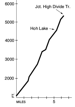
A 6.5-mile trip from the Hoh River to the High Divide Trail.
Trail type: Secondary.
Best season: Early July to mid-October.
Elevation gain: 4,300 feet.
Maximum elevation: 5,300 feet.
Topo maps: Bogachiel Peak; Custom Correct Seven Lakes Basin–Hoh.
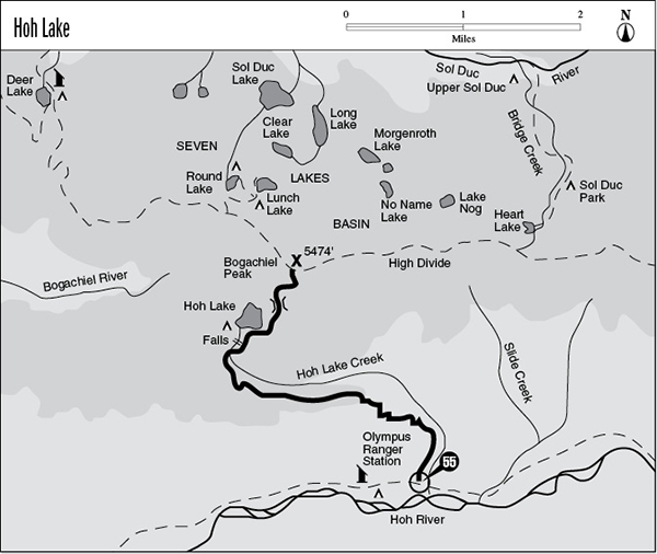
Finding the trailhead: This trail begins at mile 9.8 on the Hoh River Trail (see the Hoh River hike), just east of Olympus Guard Station.
The Hike
This trail climbs steadily up the north wall of the Hoh valley, passing the alpine basin of Hoh Lake on its way to meet the High Divide Trail. Most of the climb is across open slopes burned in 1978, and this area is baked by the sun from midday on. Campsites at Hoh Lake and CB Flats require reservations, which can be obtained at neighboring ranger stations.
The trail departs from the Hoh River Trail just east of Olympus Guard Station and runs northward across the valley floor. The chuckling sound of Hoh Lake Creek can soon be heard to the east of the trail. As the trail scales the valley wall, the trees soon give way to the brushy slopes of the Hoh Lake burn. This blaze started with a lightning strike on the lower slopes, and winds fanned the flames uphill toward Hoh Lake. The entire ridge was burned, making this one of the largest fires ever recorded in Olympic National Park. The next 2.5 miles of climbing alternate between strips of surviving trees and the brushlands of the burn, where the transpiration of the plants hits the traveler in humid waves on sunny days.
Mount Olympus from the Hoh Lake Trail
The trail completes the initial ascent atop a razor-edge ridge, which it follows across dips and rises toward the west. The open country of the burn reveals a vista of the Hoh’s braided channels meandering across its gravel bed, with the snow-dappled peaks of the Olympus massif rising above it. After entering the forest, the path makes a shallow descent into the vale of Hoh Lake Creek before resuming the climb. A marked campsite offers the last opportunity for campfires as the trail moves into alpine country, crossing seeps and streamlets that run across flowery glades.
The forest opens up when the hiker reaches CB Flats; this grassy opening offers the first glimpses of the summit of Mount Olympus. The path runs straight across the meadow, then passes beneath the first of three delightful cascades that are draped across the headwall below the foot of the lake; permits for this area must be obtained at a ranger station. The climb picks up a bit as the trail makes one long switchback to the east before depositing the traveler on the shore of Hoh Lake. This aquamarine gem sits in a compact basin with steep walls covered in alpine meadows. Marmots frolic amid the flowers and issue piercing alarm whistles upon the approach of hawks and eagles. There are several fine campsites on the far side of the outlet stream below the foot of the lake.
The main trail turns east, climbing the spur ridge above the lake. It occasionally wanders through openings that offer superb aerial views of the clear waters of the lake. The trail soon pops through a saddle in the ridgeline, and spectacular vistas open up on all sides. The glacier-clad crests of Mount Olympus preside over the scene, with Mount Mathias and Mount Tom flanking them on either side. Cat Peak rises to the east at the tail end of the Bailey Range. The path then works its way north across grassy slopes to the base of Bogachiel Peak, where it meets the High Divide Trail.
Key Points
0.0Junction with Hoh River Trail.
3.1Top of ridge.
4.5CB Flats.
5.3Hoh Lake. Turn right for the High Divide.
6.5Trail meets High Divide Trail.