56 The Bogachiel River
A 23.2-mile backpack from Forest Road 2932 to the Mink Lake–Little Divide Trail.
Trail type: Secondary.
Best season: All year.
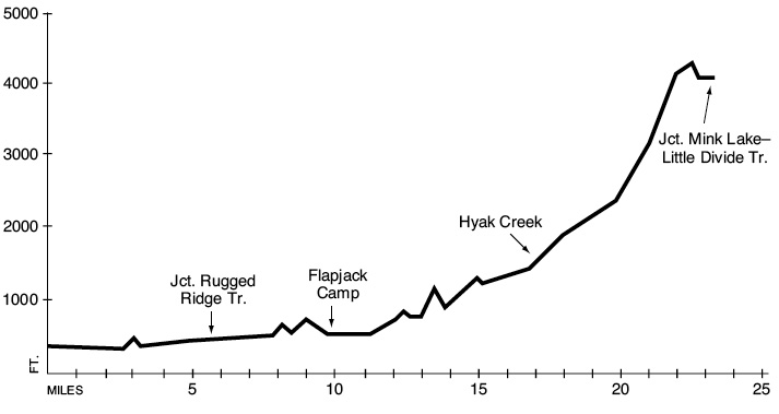
Elevation gain: 4,685 feet.
Elevation loss: 1,005 feet.
Maximum elevation: 4,304 feet.
Topo maps: Slide Peak, Hunger Mountain, Indian Pass, Reade Hills; Custom Correct Bogachiel Valley.
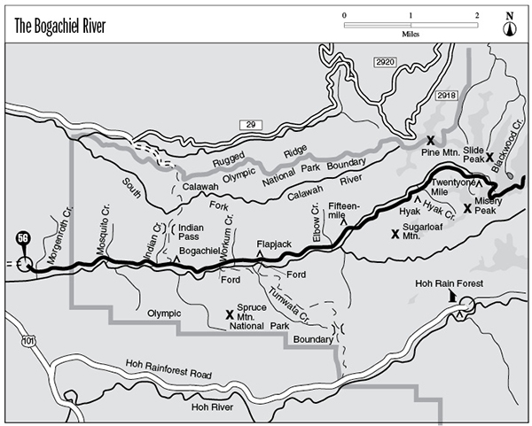
Finding the trailhead: From Forks, drive south on U.S. Highway 101 to Bogachiel State Park. Turn left (east) onto Undie Road, which becomes FR 2932. Drive about 5 miles to the trailhead at road’s end.
The Hike
This trail runs through a stunning rain forest as it ascends the wild and remote Bogachiel valley. Bogachiel (pronounced BO-guh-sheel) is a Quileute word that can be roughly translated as “waters that become muddy from rainstorms.” The waters of the river are crystal clear throughout most of the summer, however, and support winter and summer runs of steelhead. At its terminus, the trail links up with the Mink Lake–Little Divide Trail. Because the area has a relatively low maintenance priority, travelers should expect to clamber over a few deadfalls and make occasional creek fords. Horse parties should ask about trail conditions before beginning a trip.
The trek begins as the path drops into a stand of red alder to cross Morgenroth Creek. On the far bank a spur path runs a short distance to a wetlands interpretive site, while the main trail runs east up the river valley. It crosses swales and bottoms robed in alder and second-growth spruce. The scenery changes little beyond the park boundary: This entire area was extensively logged before being added to the park in the 1940s. The forest community found here is a regrowth that sprang up in the wake of clear-cutting.
The trail soon climbs over a hillside where the Bogachiel River meanders close to the edge of the bottomlands. The path then crosses Mosquito Creek, where there is a riverside campsite. The country flattens out again, and after 1.3 miles the trail crosses Indian Creek. From this point onward the landscape takes on the aspect of an ancient rain forest, with tall cedar, hemlock, and Sitka spruce scattered amid a lush undergrowth of ferns and shrubs. Just beyond a junction with the Rugged Ridge Trail, the Bogachiel camping area occupies a riverbank graced with the stately columns of age-old conifers. Many of the tent sites have been washed away by the river, but camping sites are available on riverside gravel bars. The river meanders widely across a broad peneplain of gravel, changing its course frequently during winter floods.
Another 1.9 miles of easy bottomland hiking brings the traveler to the lower ford junction, where the Hoh–Bogachiel Trail crosses the river and runs south over a lofty ridge. The main trail climbs and falls vigorously for the next several miles, avoiding the riverbanks in favor of the forested hillsides to the north. Warkum Creek is a scenic landmark to mark one’s progress through the trackless forest. It tumbles through a narrow channel carved into the mossy bedrock with several attractive cascades interrupting its flow. Just before the upper ford junction is a smaller but equally interesting stream that pours in a thin sheet across a rounded face of stone. The erosive power of this rivulet is not quite sufficient to wear a channel into the bedrock. The upper ford trail runs to Flapjack Camp on the gravel bar of the river, then on across the waters to link up with the Hoh–Bogachiel Trail.
The main trail crosses another long stretch of flat bottomland, with tall spruces underlain by moss and sword fern. The path meanders back to the riverside to meet a pair of campsites, then crosses tiny Spawner Creek. Above this point the valley constricts around the river, whose emerald waters swirl through placid pools amid the bedrock. Thick brakes of salmonberry grow beside the numerous streams that meander down from the north, providing a trailside treat for hikers and black bears in midsummer. The spruce and Douglas fir benchlands found here support a lush understory of vine maple and sword fern.
At mile 13 the main branch of the river splits away to the south unseen, and the trail begins to climb vigorously above the North Fork of the Bogachiel. High above the waters the trail reaches the Fifteenmile shelter, which is set in a grove of old western hemlocks (there are no good tent spots here). A pack bridge soon spans the North Fork, leading to a hearty climb above its south bank. The rain forest is replaced by a more montane plant community, and the forest becomes more ragged. The trail soon drops into a small, overgrown meadow with the Hyak shelter at its lower edge.
The path then arcs uphill again, crossing Hyak Creek and several lesser streams along the way. Near the head of the valley, the Twentyone Mile shelter is perched beside a stream amid a ragged grove of hemlocks. Beyond this point the trail climbs steadily for a long stretch to a flattened terrace on the ridgetop. The ascent continues along the crest of the ridge, bearing west. Before long, open meadows spangled with blossoms of all descriptions open up vistas of the surrounding country. All around, unblemished ridges clothed in virgin forest stretch away to the horizon, while the snowbound masses of Mount Olympus and Mount Tom rise above the verdant hills to the southeast. The trail continues to climb in fits and starts, ultimately reaching its end at a junction with the Mink Lake–Little Divide Trail (see that hike description).
Key Points
0.0 Trailhead.
0.2 Trail crosses Morgenroth Creek. Spur path to wetlands interpretive site.
1.6 Olympic National Park boundary and registration station.
3.2 Trail crosses Mosquito Creek.
4.5 Trail crosses Indian Creek.
5.6 Junction with Rugged Ridge Trail. Stay right.
5.7 Bogachiel Camp.
7.6 Junction with lower ford to Hoh–Bogachiel Trail. Stay left.
9.8Junction with trail to Flapjack Camp and ford to reach Hoh–Bogachiel Trail. Stay left.
11.4 Trail crosses Spawner Creek.
12.1 Trail crosses Lotloh Creek.
13.7 Fifteenmile Camp.
13.9 Trail crosses North Fork Bogachiel River.
16.5 Hyak Camp.
16.9 Trail crosses Hyak Creek.
19.4 Twentyone Mile Camp.
23.2 Junction with Mink Lake–Little Divide Trail.