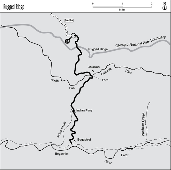
57 Rugged Ridge
A 6.6-mile day hike or backpack from the Rugged River trailhead to the Bogachiel River.
Trail type: Foot.
Best season: All year.
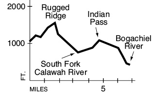
Elevation gain: 880 feet.
Elevation loss: 1,190 feet.
Maximum elevation: 1,640 feet.
Topo maps: Spruce Mountain; Custom Correct Seven Lakes Basin–Hoh.
Finding the trailhead: From Forks, drive north on U.S. Highway 101 to mile 193.2. Turn east onto Forest Road 29 and drive 11.5 miles. At the junction with Forest Road 29-070, turn right at the sign for the Rugged Ridge Trail. Follow this narrow gravel road 2.3 miles to the trailhead at road’s end. The trail begins a short distance downhill from the parking area.
The Hike
This trail offers an alternate and perhaps more interesting route into the lower valley of the Bogachiel River. It begins by snaking up to the top of Rugged Ridge through a mature forest that blocks out the sun. Atop the ridge, a registration station at the park boundary provides the backcountry permits that all backpackers must carry. The path then plots a sinuous course among finger ridges so numerous that it is difficult to determine when Rugged Ridge has actually been crossed. The forest here is dominated by Douglas fir and western hemlock and retains a lowland character despite its position on the crest of a ridge. Deer fern and woods sorrel are common on the dimly lit forest floor, and clumps of sword fern occupy the occasional damp swale.
After 1.8 miles the trail begins its descent into the South Fork Calawah valley. It passes through an old-growth forest that has remained undisturbed. The route runs westward as it drops, and holes in the canopy allow brush to grow in the sunny gaps. Soon after reaching the valley floor, the traveler must make a shallow ford of the South Fork of the Calawah River. The primitive campsite once found here was washed out by flooding in 2003, and it is now difficult to find a spot to pitch a tent here. Dark rain forest awaits on the far shore.
The trail then bends southwest as it climbs through the damp forest to reach Indian Pass. This low saddle in an otherwise unbroken ridge is a bit of a geological mystery. It is loosely forested with giant conifers, whose massive boles rise through a multistoried canopy of younger trees. The tallest of these trees are Douglas fir and Sitka spruce, while western hemlocks rise to lesser heights. The trail then winds gradually downward across a series of level terraces to enter the spectacular rain forest bottomland of the Bogachiel River. It joins the Bogachiel River Trail (see previous hike) in an ancient stand of spruces just west of Bogachiel Camp.
Key Points
0.0Trailhead.
0.4Olympic National Park boundary and registration station.
3.2Site of Calawah Camp. Trail fords South Fork Calawah River.
4.7Indian Pass.
6.6Junction with Bogachiel River Trail.