
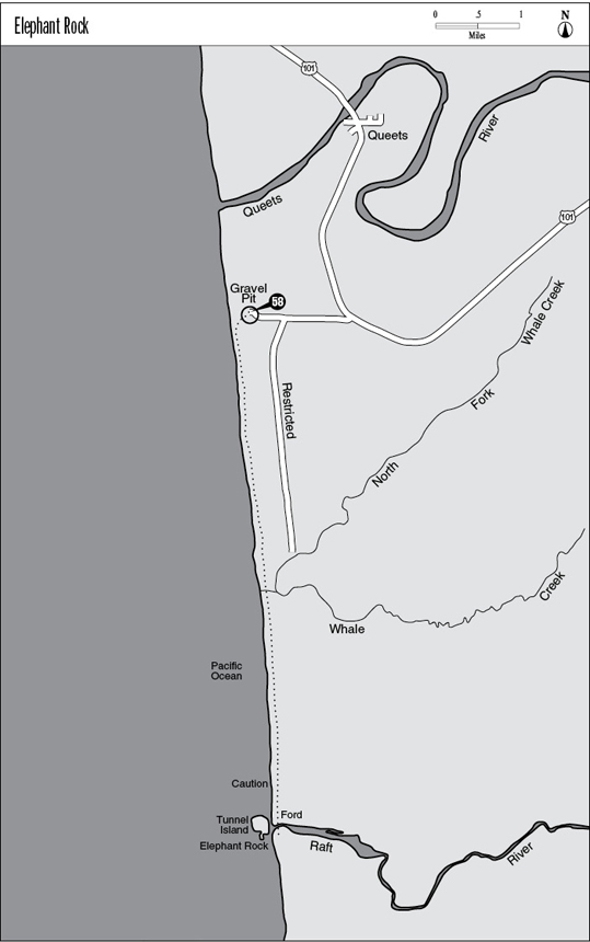
Elephant Rock rises at the mouth of the Raft River.
58 Elephant Rock
A day hike along the beach to a series of arches and sea stacks, 3.6 miles one way.
Trail type: Coast route.
Best season: Spring, summer, fall.
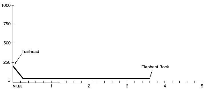
Elevation gain: None.
Elevation loss: 90 feet.
Maximum elevation: Sea level.
Topo maps: Tunnel Island, Queets.
Jurisdiction: Quinault Indian Reservation.
Finding the trailhead: Take U.S. Highway 101 southeast from the town of Queets to mile 150.4. Here an improved gravel road runs westward past several small work centers. After 0.5 mile the road splits; continue straight ahead on the right for an additional 0.3 mile and park at the old gravel pit on the bluffs above the beach. A Quinault Reservation beach pass is required to visit these tribal lands; it must be obtained at the town of Taholah, which lies at the end of Highway 109, accessible from Hoquiam via Ocean Beach Road or from the Moclips Highway, a gravel road that departs US 101 a few miles south of Lake Quinault.
The Hike
This day hike visits a cluster of arches and sea stacks at the mouth of the Raft River, including fanciful Elephant Rock. This hike is on the Quinault Indian Reservation; visitors must get a beach pass from the tribal government for a nominal fee. Overnight camping is not allowed on the reservation; visitors must approach the trek as an out-and-back affair in one day. Although the hike is almost level, the very tricky descent to the beach and the soft nature of the beach sands and gravels make for a physically demanding trek. Time your hike to round the headland beside Tunnel Island and ford the Raft River at low tide. Coastal access to Elephant Rock from the south is blocked by Pratt Point, an impassable headland, so this trek approaches the formations from the north.
The hike begins with a very steep and tricky descent along a footpath that departs from the south side of the parking area. Watch your footing as the track drops precipitously down an eroded hillside. Near the bottom an almost sheer ravine with a fixed-rope rappel plummets the last 15 feet or so to the beach. Take a bearing on the landmarks here, to be sure you can locate the exit route on the return leg of your trip.
Elephant Rock rises at the mouth of the Raft River.
On the beach turn south along the sandy strand that runs along the base of eroded cliffs of conglomerate. Far ahead the tree-covered mass of Tunnel Island protrudes into the surf, marking the hike’s destination. About halfway there the two forks of Whale Creek form a small lagoon, and the shell of an old summer cabin is sagging into ruin nearby. Watch for signs of landslides and slumping to the south of Whale Creek, as the twin forces of wave action and seeping groundwater combine to undermine the stability of the bluffs and cause mudslides.
There is one rocky headland to negotiate just north of Tunnel Island, and you may have to do some rock-hopping to keep your feet dry if the tide isn’t at its low ebb. After rounding the headland you will reach the mouth of the Raft River as you draw abreast of Tunnel Island. At low tide the ford is knee-deep to ankle-deep, with a significant current. Expect problems getting across at high tide. A wrack of giant logs and roots guard the estuary of the Raft River, where bald eagles are sometimes sighted.
On the far bank the origins of Tunnel Island’s name soon become apparent, as the grotto at its south end has been drilled all the way through the bedrock of the island. The south side of the island is replete with multiple arches, including the fancifully shaped Elephant Rock, with its multiple arches and pillars resembling an ossified pachyderm. Off in the distance the Hogsback rises at the edge of the surf, and sea stacks including Willoughby Rock and Split Rock are scattered across the face of the sea. Several of the stacks that flank Tunnel Island serve as rookeries for seabirds such as pelicans and cormorants, making this a great spot for bird-watching. Elephant Rock marks the end of the hike; after enjoying the area, turn around and retrace your steps to the parking area.
Key Points
0.0 Trail leaves parking area near East Entrance.
0.1 Path reaches the beach. Turn left (south).
1.7 Whale Creek.
3.3 Headland beside Tunnel Island. CAUTION: Passable at low tide.
3.5 Ford of Raft River—ankle to waist deep at low tide.
3.6 Route draws even with Elephant Rock.