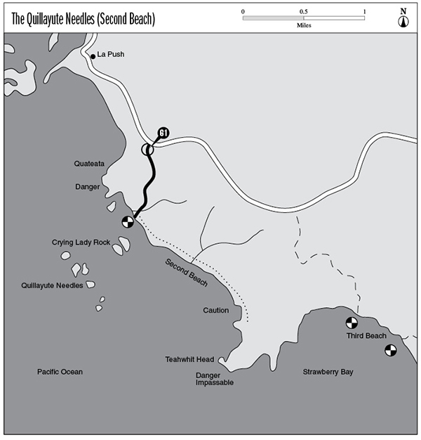
61 The Quillayute Needles (Second Beach)
A 2.4-mile day hike from the Second Beach trailhead to the base of Teahwhit Head.
Trail type: Coast route.
Best season: All year.
Topo maps: La Push, Quillayute Prairie; Custom Correct South Olympic Coast.
Finding the trailhead: From Forks, drive north about 1 mile on U.S. Highway 101 to La Push Road. Turn left (west) and drive 12.7 miles (following signs for La Push) to the well-marked Second Beach trailhead.
The Hike
This trail begins on the Quileute Indian Reservation, and disputes over territorial sovereignty have sometimes led to the closure of this route. The route follows the Second Beach Trail down to a sandy stretch of coastline, offering a short day hike or a good family overnight. The trail begins by winding through a forest of Sitka spruce and western hemlock that sprang up in the aftermath of logging that occurred early in this century. After wandering the wooded blufftop for a time, a wooden boardwalk and steps drop down to the north end of Second Beach. An enormous block of contorted stone named Quateata blocks the northern approaches to the beach, and it is pierced by a natural arch. The Quillayute Needles are scattered across the sparkling waters of the Pacific. This formation is an old wave-cut terrace that has been elevated and weathered into sandstone pillars. Some are massive and stout while others form slender spires.
Turn south and follow the coast as it bends away toward Teahwhit Head. The beach spreads out into a wide stretch of fine sand, raked ceaselessly by turbulent combers. Near its south end sheer cliffs march down to the water’s edge, and tortured stacks stand among the breakers. Tidepools among the rocks showcase delicate sea anemones and colorful starfish. A passage can be made around the first headland, which guards an isolated beach. From this point a natural arch can be seen among the jagged spires of Teahwhit Head. The next headland is trickier to negotiate and can only be crossed during extremely low tides. Beyond it is a secluded cove much like the previous inlet, and a rugged jumble of boulders stretches southwest toward the forbidding and impassable cliffs of Teahwhit Head.
Key Points
0.0Second Beach trailhead.
0.7Trail reaches beach. Turn south.
2.1Headland. CAUTION: 4-foot tide.
2.2Headland. CAUTION: 1-foot tide.
2.4Teahwhit Head. DANGER: impassable headland.
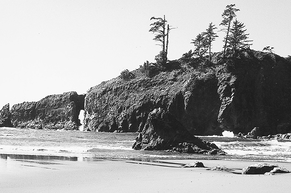
Quateata guards the northern approach to Second Beach.