
A view of Jagged Island from the old coastwatcher’s shack
62 The Shipwreck Coast
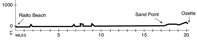
A 20.1-mile backpack from Rialto Beach to the Ozette Ranger Station.
Trail type: Coast route.
Best season: Spring, summer, fall.
Topo maps: La Push, Allens Bay, Ozette; Custom Correct’s North Olympic Coast is most recommended.
Finding the trailhead: From Forks, drive about 1 mile north on U.S. Highway 101 to La Push Road. Turn left (west) and drive 7.6 miles to the fire station. Turn right here on the road to Mora, and continue 4.8 miles to the Rialto Beach trailhead at road’s end.
The Hike
This wild and beautiful expanse of coastline stretches from Rialto Beach in the south to Sand Point in the north. It is commonly approached as a three-day trip, but it can also be combined with the Ozette Loop and Point of the Arches route for a much longer trip. The coastline is typified by boulder-strewn coves and rocky headlands, which makes for more difficult traveling than the sandy beaches found farther south. There are few trails navigating around the headlands because most are passable during low tide. By the same token, hikers can be easily isolated at high tide, so it is imperative to pay close attention to tide levels while exploring this area. A quota system is in effect from the Yellow Banks northward to the campsites north of the Ozette River. Advance reservations are required for this zone. Call the park’s Wilderness Information Center at (360) 452-0300.
The trek begins at Rialto Beach; the registration station is located along a barrier-free path to an overlook. The cobble-strewn beach extends north for 3 miles. Enormous drift logs have been brought down the river during winter floods, battered and polished by wave action, then heaved high onto the beach by storms. These same winter gales have sculpted the Sitka spruce that crowd the beach in low-growing forms that resemble the krummholz of timberline. A long spit extends south from the mouth of the Quillayute River toward the James Island archipelago. This cluster of islands sports stout, wave-carved cliffs of sandstone topped with spruce and alder. The Quileute tribe once used this cluster of islands as a natural fortress when fierce bands of Makah swept down the coast during the course of intertribal warfare.
As the route runs northward, Cake Rock is the major stack that rises far out to sea, while the more ragged crest of Dahdayla Island rises from the surf closer to the beach. The traveling is easy all the way to Hole-in-the-Wall Rock. True to its name, this minor promontory is pierced by a rounded aperture worn through the stone by centuries of wave action. A short trail climbs around the head, which can be passed on the ocean side only at low tides. Upon rounding the first major headland (use caution), the trail encounters a broad ledge of bedrock guarded by a constellation of igneous rock spires. This shelf drains free of water at low tide, allowing excellent opportunities for tidepool exploration.
After rounding a sharp, forested point of land, the route enters a rather rocky cove. Here a plaque commemorates the wreck of the schooner W. J. Pirrie, a cargo vessel of Chilean registry. This ship went down in a fierce winter storm in 1920, with the loss of all hands. The next headland is Cape Johnson, and it marks the beginning of 1.2 miles of tricky boulder-hopping across the algae-covered rocks of the intertidal zone. Deep tidepools reveal the denizens of the marine environment in pursuit of their daily activities. Hermit crabs and purple shore crabs scuttle about in search of scraps, sea anemones strain the water for plankton with their stinging tentacles, and starfish crawl about with glacial slowness in pursuit of their immobile bivalve prey. Harbor seals commonly haul up onto the outer banks to sun themselves, and the occasional bald eagle may be seen patrolling the coastline.
A view of Jagged Island from the old coastwatcher’s shack
After rounding the next head (once again impassable at high tide), Carroll and Jagged Islands can be seen to the north. Carroll Island is a major rookery for Steller’s sea lions and also has nesting colonies of auklets, puffins, and storm petrels. The route then returns to a beach of coarse sand for easy traveling as far as “Saddle Rock.” A short traverse provides access around this small head, then returns the traveler to beach level. Here wide stretches of sand beckon, and outgoing tides trap shallow lagoons of salt water on the flats. Look for rafts of seabirds in the shallows; cormorants and black brant are sometimes seen amid the ever-present gulls.
A steep cliff known locally as “Coastie Head” lies 0.8 mile north of Saddle Rock. The trail that navigates over it is well worth the effort even at low tide: It offers a fine viewing platform of the neighboring sea stacks and passes a historic coastwatcher’s shack. This observation post was manned periodically during World War II, when the threat of invasion by the Japanese was an ever-present concern. The strand of coastline to the north is bordered to the landward side by a dike of cobbles and storm-tossed driftwood. Several small streams form brackish lagoons behind this natural dam. The summer ranger tent and old Starbuch Mine site lie near the center of the bay. This was the site of a placer mining operation that produced small quantities of gold between 1910 and 1920. The Cedar Creek emergency shelter is nestled among the spruces near the north end of the bay.
After rounding the next headland, the route reaches Kayostla Beach. There is a small stream here, and plenty of good campsites are located among the trees. At the north end of the beach, the Norwegian Memorial gives silent testimony to the wreck of the bark Prince Arthur in 1903. The granite obelisk is set back in a forest glade, but a trail sign visible from the beach marks its location. Beyond this spot a series of rocky headlands slow northward progress to a crawl. At first the heads are of naked bedrock, with arches and grottoes carved out by the waves. This soon gives way to a barren peneplain of sandstone, pocked with tidepools that harbor darting sculpins and scuttling crabs. Climb up the bluffs to glass for sea otters, which are commonly seen in this vicinity.
Beyond “Face Point” is a rocky cove preferred by seals for hauling out. Wooded bluffs crowd the waters of this small bay, and more barren stone, paired later with beaches of deep gravel, make traveling a toilsome affair. The sandy strands return below the Yellow Banks, a series of steep, eroded bluffs of glacial loess. This sediment was carried by the wind from glacial outwash plains to be deposited far out on the flats during the Pleistocene and earlier ice ages. At the north edge of the cove lies a tricky point, through which a tunnel has been dug for easier access.
Hikers must then clamber over pillars of bedrock, but this rough stretch passes quickly. A long expanse of sandy beach stretches away to Sand Point, where most travelers turn inland toward Ozette Lake. The first target to be reached marks the Ericksons Bay Trail, which is a dead-end spur to Ozette Lake. The Sand Point Trail lies 0.7 mile to the north, in a grove of young Sitka spruce. It can be followed for the remaining 3 miles to the Ozette Ranger Station, or the longer route along the coast to Cape Alava can be used to reach the same terminus. This latter route and the Sand Point Trail are discussed in detail under The Ozette Loop hike.

Key Points
0.0Rialto Beach parking area. Turn north at the shoreline.
1.6Hole-in-the-Wall Rock. CAUTION: 5-foot tide. Optional overland trail.
2.3Headland. CAUTION: 5-foot tide.
3.8Chilean Memorial.
4.5Cape Johnson. CAUTION: 4-foot tide.
5.2Headland. CAUTION: 5.5-foot tide.
6.7“Saddle Rock.” DANGER: Use overland trail.
7.5“Coastie Head.” CAUTION: 4-foot tide. Optional overland trail.
7.7Coastie Head overland trail returns to beach.
8.7Cedar Creek.
8.8Headland. CAUTION: 5.5-foot tide. Optional overland trail.
10.0Norwegian Memorial.
11.9“Face Point.” CAUTION: 6-foot tide.
14.5Yellow Banks.
15.0Rocky point. CAUTION: 5-foot tide. Optional tunnel.
16.4Target marks Ericksons Bay spur trail. Keep going north.
17.1Sand Point target. Turn east for Ozette Lake.
20.1 Ozette Ranger Station.