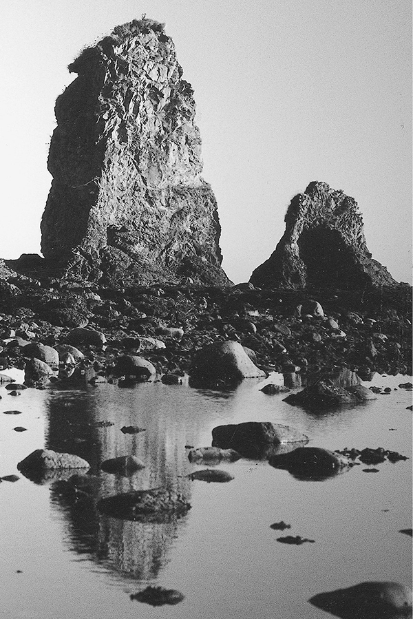
Stacks and tidepools south of the Wedding Rocks
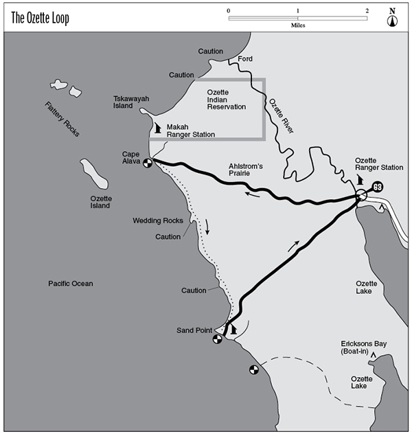
63 The Ozette Loop
A long day hike or short backpack, 9.3 miles round-trip.
Trail type: Coast route.
Best season: All year.
Topo maps: Ozette; Custom Correct Ozette Beach Loop.
Finding the trailhead: From Sappho on U.S. Highway 101, drive north on Highway 112 to Clallam Bay and the village of Sekiu. At 2.3 miles west of Sekiu, turn left (south) onto Ozette Road, which is paved for most of its 20-mile length. The trailhead is located beside the ranger station at road’s end.
The Hike
This trail offers a short-range day hike or backpack along a part of the coast that is inaccessible by car. It receives heavy use due to its ease of access, and a permit reservation system is in place for overnight camping between the Yellow Banks and the Ozette River. Reservations should be sought by phone, mail, or in person at least two days before the planned trip; weekends are particularly busy, and getting reservations a week in advance for these days is advisable. Backpackers should bear in mind that the only reliable fresh water along the coastal part of the route is at Cape Alava and Sand Point. The hike is described here going counterclockwise around the loop, but it could be done either way.
The trail leaves the Ozette Ranger Station heading west, and a broad bridge soon arches above the sluggish waters of the Ozette River. Soon after entering the forest, the trail branches into two paths. The right fork heads toward Cape Alava and the left fork to Sand Point (the return leg of this loop). Bear right on the Cape Alava Trail, which wanders west through young spruce and hemlock underlain by deer fern. The gigantic leaves of skunk cabbage appear in clumps in the boggy pockets of the forest.
The trail soon becomes a boardwalk causeway that may be quite slippery during rains. At mile 2.3 the trail passes a large rest area that is actually the site of Lars Ahlstrom’s barn, long since burned down. The broad stretch of coastal prairie to the west of it is named Ahlstrom’s Prairie in honor of this man, who built the original causeway and was for a time the westernmost homesteader in the United States. A few fruit trees remain to the south of the trail, while the deteriorating buildings of the homestead lie out of sight to the north. This coastal prairie is really a wet bog, filled with sedges, crowberry, and sundews. The sundew is carnivorous: Hairs on the leaves produce droplets of a sticky, sweet-smelling substance that traps ants and flies. After crossing an opening the trail enters a superb coastal rain forest dominated by Sitka spruce and sword fern. It then descends from the bluff to reach the shoreline at Cape Alava.
Stacks and tidepools south of the Wedding Rocks
Upon reaching Cape Alava, visitors are immediately impressed by the collection of large, spruce-encrusted islands that loom offshore. To the north is Tskawayah Island, so close to shore that it can be reached on foot at low tide. This island is part of the Ozette Indian Reservation, and climbing onto it is not permitted. Far to the west the Bodelteh Islands appear to be a single mass from this vantage point. The long, lean ridge of Ozette Island rises across a rocky tidal flat to the southeast. Cape Alava is reputed to be one of the best places on the coast to see marine mammals, including the majestic gray whale. This whale is unusual in that it lives on a diet of amphipods that it filters from seafloor sediments. There are campsites among the trees and a tiny creek for fresh water; campers should be aware that raccoons are particularly persistent pests in this area. The Makah Ranger Station lies a short distance to the north. A Makah village stood here for untold centuries, and a succession of mudslides buried the site from time to time. The result was one of the most important archaeological digs in North America. The dig site is currently inactive but should not be disturbed. A binder at the site contains a laminated magazine article that offers additional information on this historic village site. The last permanent residents of this village had departed by 1917, but the Makah still return to a small reservation just to the north on a seasonal basis.
Turn south, following a narrow strip of gravel that is deep and soft. A rocky shelf borders the beach, and at low tide the numerous tidepools provide windows into the world of sea creatures. The first headland to be reached is the site of the Wedding Rocks, where a collection of 300-year-old petroglyphs grace the soft graywacke boulders. The petroglyphs are on boulders above the high-tide mark, clustered in two groups: One group is centered 50 yards to the north of the headland, while the other group is 25 yards southeast of it. There are more than fifty petroglyphs in all, featuring marine mammals, a two-masted sailing bark, and human figures. The most famous petroglyph is the “wedding scene,” from which the rocks derive their name. It consists of a male and female figure surrounded by bisected circles, which are a sort of sexual symbol. Carving or defacing of the petroglyph site is a federal crime; please report any violations immediately.
The traveling continues to be rather laborious as the trail rounds the next headland to the south of the Wedding Rocks. Here isolated spires rise in a surreal landscape like forgotten chessmen on an enormous playing board. Far out to sea the stately walls of White Rock rise sheer from the open ocean. Cormorants, common murres, and glaucous-winged gulls nest on this isolated stack, and their droppings give the island its white color. After rounding a rocky head, the trail crosses the shallow bay that leads to Sand Point. True to its name, sandy beaches surround this long spit that juts into the Pacific. There are campsites and a shelter among the trees to the south of the point, and the acidic waters of a tiny creek provide the only supply of water.
Just around the point a target marks the trail returning to the Ozette Ranger Station. This path is almost entirely boardwalk and has lots of stairs on it. After beginning in a Sitka spruce forest, the causeway breaks out into an old burn that is now a jungle of salal and other shrubs. A few old cedars survived the fire and rise high above the brushy understory. Shortly after returning to the forest, the trail rejoins the Cape Alava Trail for the final 0.2 mile to the Ozette Ranger Station.

Key Points
0.0Ozette Ranger Station. Trail crosses Ozette River.
0.2Trail splits into Sand Point and Cape Alava Trails. Bear right.
3.3Cape Alava. Turn south along the coast.
4.3Wedding Rocks. CAUTION: 5-foot tide.
4.8Headland. CAUTION: 5.5-foot tide.
6.2Sand Point.
6.3Sand Point target. Follow trail east for Ozette Lake.
9.1Trail rejoins Cape Alava Trail.
9.3Trail crosses Ozette River to return to Ozette Ranger Station.