64 Point of the Arches
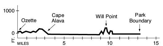
A 13.4-mile backpack from Ozette Lake to the north end of Shi Shi Beach.
Trail type: Coast route.
Best season: All year.
Topo maps: Ozette, Makah Bay; Custom Correct North Olympic Coast.
Finding the trailhead: From Sappho on U.S. Highway 101, drive north on Highway 112 to Clallam Bay and the village of Sekiu. At 2.3 miles west of Sekiu, turn left (south) onto Ozette Road, which is paved for most of its 20-mile length. The trailhead is located beside the ranger station at road’s end.
The Hike
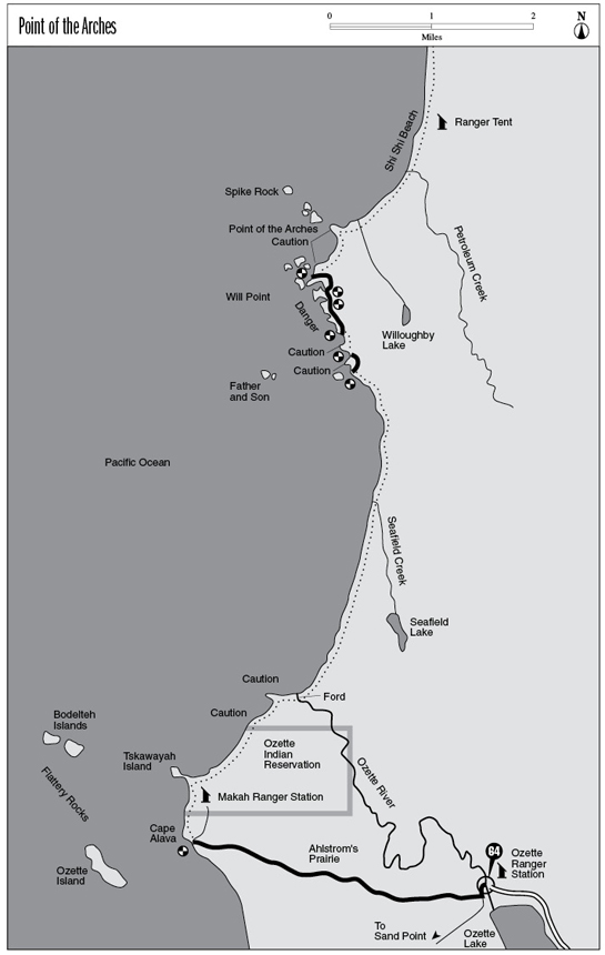
This route covers a wild and beautiful stretch of coastline north of Ozette Lake. There are some steep climbs aided by fixed ropes near Will Point. The former northern access to Shi Shi Beach is no longer open to the public, so travelers to Point of the Arches must count on returning by the same route that they came. A new northern access route has been blazed to Shi Shi Beach, which means that this historically remote backcountry area becomes crowded at times with day hikers. Detailed descriptions of the trail to Cape Alava as well as the Cape area itself can be found under The Ozette Loop hike.
From Cape Alava turn north and cross the spit that goes to Tskawayah Island, staying on the mainland. The first headland to be encountered is attended by a number of small, picturesque sea stacks. Beyond a small and shallow cove is a second head, this one an imposing promontory of rock. Wave action has carved deep grottoes into the bedrock, and these can be explored when the tide is out. Just beyond this point is a ford of the Ozette River. It is really no more than a medium-size creek and is less than knee-deep at low tide.
Beyond the river lies a long arc of beach, guarded to the north by the Father and Son formation standing far out to sea. Traveling is initially quite easy across firmly packed sands. The bluffs above the beach are composed of a fractured form of bedrock known as melange and are continually slumping down onto the beach in the face of incessant erosion. Alders cover these unstable slopes, pioneering a forest stand and growing rapidly on the exposed soils, only to be cast down by the next mudslide. About halfway across the shallow bay, the sand gives way to deep gravel, and traveling becomes more taxing.
The sand returns on the far side of Seafield Creek, and numerous boulders pock the intertidal zone with sand tidepools. Turban snails thrive here, and mussels and barnacles coat the rocks. As the tides recede this area presents a remarkable exhibition of the Olympic coast’s diverse assortment of starfishes. These spiny-skinned animals are a relative to the sea urchin and the sand dollar, and more species of starfish occur in Olympic coastal waters than anywhere else in the world. Do not disturb these fragile creatures; they are easily killed by handling.
The headland that marks the northern boundary of the bay is a real challenge to traverse: Its jumbled piles of large boulders require time-consuming and strenuous acrobatics. After this point has been successfully crossed, an optional headland trail leads over the top of the next point. Atop the saddle are a few ancient Sitka spruces that demonstrate a radically different growth form than their lofty rain forest cousins. One more headland must then be negotiated before the Will Point Trail is reached. Here the impassable cliffs are guarded by sharp teeth of stone that send up plumes of spray as the surf beats against them. Will Point is an isolated pluton of metamorphic rock, with eroded stacks stretching far out to sea.
The Will Point Trail runs for 0.3 mile along the bluff tops, then drops into a narrow cove hemmed in by sheer walls. After crossing the cove the path returns steeply to the bluffs. It cruises through a dark forest of young spruce as it rounds a small bay, then makes its way out onto a neck behind Will Point. This high saddle boasts an excellent view of the Father and Son, and the booming surf surges through a tunnel of bedrock at the foot of the cliffs. The jagged stacks of Point of the Arches rise from the breakers to the north.
The path then makes an extremely steep descent to return to sea level, dropping the traveler into a wonderland of rock towers and tunnels. The route passes through an arch in the bedrock, making a fitting approach to Point of the Arches. A string of stacks and islands runs into the sea from this point, and the waves have carved an assortment of stout tunnels, deep grottoes, and delicate arches into the stone. Some of these are best viewed from Shi Shi Beach, a broad expanse of sandy coastline that stretches away to the north. Pronounced “shy-shy,” this sandy strand is 2.3 miles long. Petroleum Creek and several smaller streams provide fresh water, and a backcountry ranger is usually stationed here. Its northern end signals the park boundary and is itself guarded by a small collection of spires and arches.
Key Points
0.0Ozette Ranger Station. Trail crosses Ozette River.
0.2Trail splits into Sand Point and Cape Alava Trails. Bear right.
3.3Cape Alava. Turn north along the coast.
3.8Makah Ranger Station.
4.0Tskawayah Island.
4.8Headland. CAUTION: 5-foot tide.
5.2Headland. CAUTION: 4-foot tide.
5.5Ford of Ozette River.
6.0Headland. CAUTION: 6-foot tide.
7.6Seafield Creek.
8.9Headland. CAUTION: 5.5-foot tide.
9.0Headland. CAUTION: 4-foot tide. Optional overland trail.
9.3Headland. CAUTION: 4-foot tide.
9.4Beginning of Will Point overland trail. DANGER: impassable coastline.
10.0Trail drops briefly into narrow cove.
10.4Will Point overland trail returns to beach.
10.7Headland crossing. CAUTION: 6-foot tide.
11.1Point of the Arches. CAUTION: 4.5-foot tide. South end of Shi Shi Beach.
12.0Petroleum Creek.
13.4National Park Boundary, north end of Shi Shi Beach.