65 Shi Shi Beach
An out-and-back day hike or short backpack from the Makah Reservation to the northernmost beach in Olympic National Park, 2.2 miles one way.
Trail type: Foot.
Best season: All year.
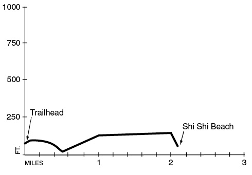
Elevation gain: 195 feet.
Elevation loss: 235 feet.
Maximum elevation: 180 feet.
Topo maps: Makah Bay; Ozette (for Point of the Arches); Custom Correct North Olympic Coast.
Jurisdiction: Makah Indian Reservation and Olympic National Park.
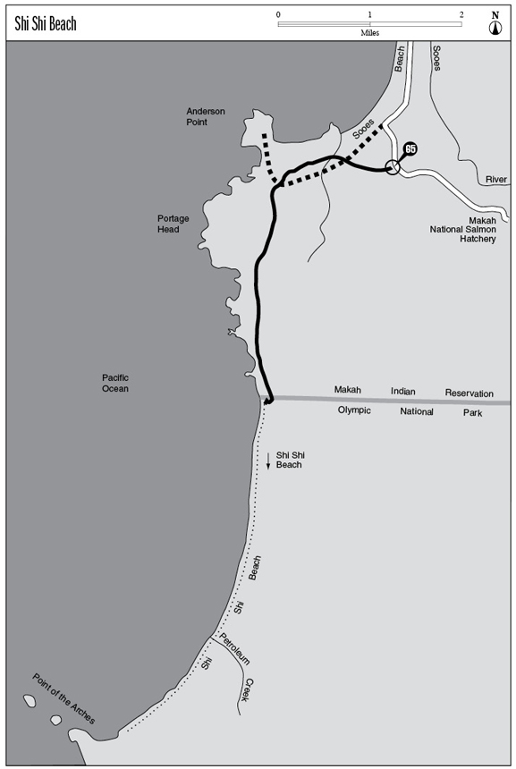
Finding the trailhead: From the west end of the town of Neah Bay, take Cape Flattery Road. After 2.5 miles, turn left onto the Hobuck Road, staying left and following signs for the Makah National Fish Hatchery. The road approaches the coastline at Hobuck Beach, swings inland to cross the Sooes River, then swings close to the coast again at Tsoo Yess Beach. At the far end of the beach, the road climbs a wooded bluff to reach the well-marked Shi Shi Trailhead at mile 4.5.
The Hike
This new trail was recently rebuilt to offer access for day hikers to Shi Shi Beach, one of the more striking areas on the Olympic coastline. The good news is that access to this beach is now fast and easy; the bad news is that Shi Shi Beach, once a secluded destination for backcountry beach hikers, has turned into a somewhat busy day-hike destination, spoiling the remoteness once found here. All visitors on this trail will need a visitor’s pass from the Makah Tribe to cross the tribal lands along the way, and overnight campers will also need a backcountry permit from Olympic National Park (the nearest ranger stations are far away at Ozette and Forks). Visitors should leave their pets at the car, as they are not allowed past the Olympic National Park boundary or along Shi Shi Beach itself. For a long day hike, travelers can walk the beach southward for an additional 3 miles to reach Point of the Arches.
The trek begins on a mix of boardwalk and footpath that winds through several logged-over areas, by turns a dense growth of young hemlocks and a clearing crowded with a riot of underbrush. After crossing a well-worn track (the former Shi Shi Trail, which crosses private property), the path tunnels through heavy vegetation to reach a cantilever bridge that spans a boggy rivulet choked with skunk cabbage. Here the path visits a wonderful grove of ancient spruce, hemlock, and cedar. Watch for the telltale buttress roots at the base of the big trees, indicating that they got their start atop elevated stumps or nurse logs as young seedlings.
The path now climbs several small hills as it rises through the forest to intersect the original trail, arrowing through the forest. The hike adopts this original trail for a gradual climb through a stand of red alders. A narrow defile between two steep hillsides marks the high point of the hike. As the trail drops gradually through the trees, a series of muddy spots must be negotiated. Soon the path is wandering through groves
of stately hemlocks, punctuated here and there by scruffy Alaska yellow cedars and massive specimens of Sitka spruce. The pounding of the surf is now audible below, but it is not until the trail reaches the top of the grade down to Shi Shi Beach that you will get an unobstructed view of the water.
At the boundary of Olympic National Park, a veritable staircase of tree roots plummets down the forested face of the bluffs to deposit the traveler at the north end of Shi Shi Beach. A small cluster of arches and pinnacles graces the surf near at hand, while the jagged teeth of Point of the Arches rise to the south, a 3-mile beach walk away.
Key Points
0.0Trailhead on Hatchery Road.
0.6Cantilever bridge.
0.9Trail crosses through narrow saddle.
2.1Olympic National Park Boundary. Trail begins a steep descent.
2.2Shi Shi Beach.

The cantilever bridge leads through a grove of old-growth spruce and hemlock.