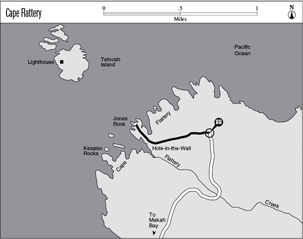
66 Cape Flattery
A short day hike across the Makah Indian Reservation to a craggy headland that marks the northwesternmost point in the lower 48 states, 0.6 mile one way.
Trail type: Foot.
Best season: All year.
Elevation gain: None.
Elevation loss: 200 feet.
Maximum elevation: 320 feet.
Topo maps: Cape Flattery; Custom Correct North Olympic Coast.
Jurisdiction: Makah Indian Reservation (tribal visitor’s permit required).
Finding the trailhead: From the west end of the town of Neah Bay, take Cape Flattery Road. After 2.5 miles, stay right at the intersection and follow the signs for Cape Flattery as the road turns from pavement to gravel and ends at the trailhead.
The Hike
This hike makes a short traverse through the Makah tribal wilderness to reach the crest of Cape Flattery, where stark cliffs rise above sea stacks and grottoes carved out by the thundering surf. This spot is one of the most dramatic “land’s ends” on Earth, marking the northwesternmost point in the coterminous United States. Cape Flattery was named by Captain James Cook, the European discoverer of the Hawaiian Islands, who named this important nautical landmark that “flattered” him with the hopes of finding a safe harbor (there was none). Of course, the Makah people and other Native Americans had been using this area for many thousands of years to hunt, fish, and gather seagull eggs.
The hike begins on a wide path that descends steadily through heavy forest. Most of the big trees are red cedar and western hemlock, with red alder present in abundance as well. The path soon levels off to become a boardwalk crossing a small swamp on an elevated bench, then becomes a steady (and sometimes slippery) drop through the hemlocks. Watch for giant specimens of Sitka spruce as the path makes its way onto a narrow, wooded promontory high above the surf. Soon the first observation platform can be seen to the south, offering views of sea stacks and the Hole in the Wall, a deep, fjordlike cove guarded by sheer cliffs. There are two more observation decks on the north side of the promontory en route to land’s end, and these high perches overlook deep caves and grottoes whittled into the sandstone of the Cape by the booming surf.
The path ends at a platform atop the farthest-reaching pillar of stone on Cape Flattery. From here panoramic views take in the striking architecture of coves and pillars both north and south, as well as the turtle-shell back of Tatoosh Island with its squat lighthouse. This islet, named for the fierce leader Tatooche of the Makah people, provides a rookery for sea lions and sea birds, which are often spotted hunting in the surrounding waters.
Key Points
0.0 Trailhead.
0.3 First observation platform above the Hole in the Wall.
0.6 Trail ends at the tip of Cape Flattery.
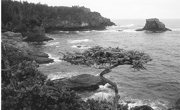
A wind-torn hemlock guards the tip of Cape Flattery.