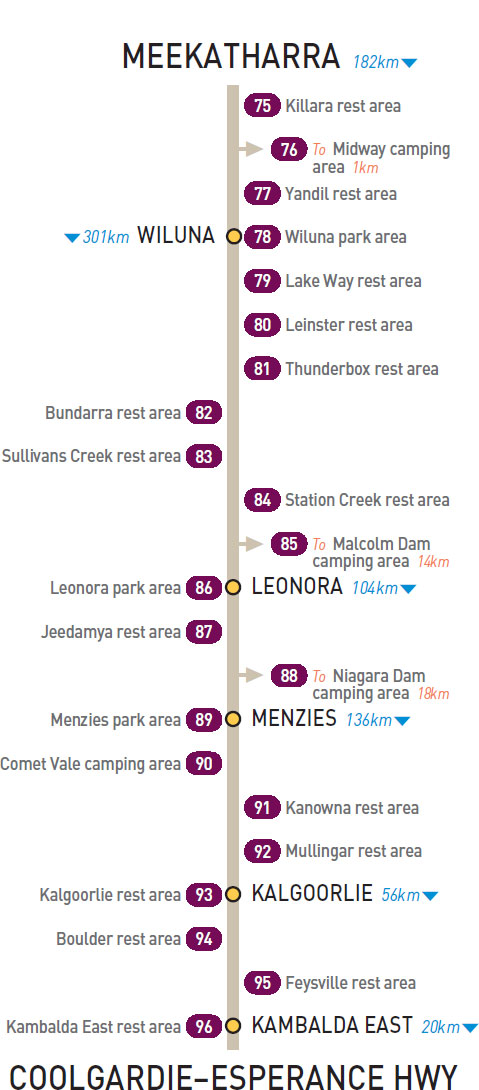
47km E of Meekatharra (L) or 135km W of Wiluna (R)
Just off the highway behind some small trees and bushes.
| GPS: S26 28.394 E118 55.610 | MAP: E10 |
T/O 96km E of Meekatharra (L) or 86km W of Wiluna (R)
Secluded in scrub 1km north of the highway.
| GPS: S26 27.427 E119 24.203 | MAP: E9 |
114km E of Meekatharra (L) or 68km W of Wiluna (R)
Just off the highway with good views over the surrounding countryside.
| GPS: S26 28.685 E119 35.027 | MAP: F9 |
At Wiluna
Adjacent to the highway. In the middle of town.
| GPS: S26 35.709 E120 13.492 | MAP: F10 |
59km S of Wiluna (L) or 242km N of Leonora (R)
Well off the highway with good views over the surrounding countryside.
| GPS: S27 02.410 E120 24.647 | MAP: G10 |
173km S of Wiluna (L) or 128km N of Leonora (R)
Just off the highway in scrub behind the parking bay.
| GPS: S27 57.093 E120 43.117 | MAP: G1, G11 |
211km S of Wiluna (L) or 90km N of Leonora (R)
Surrounded by scrub just off the highway.
| GPS: S28 10.177 E121 00.305 | MAP: G1, G12 |
221km S of Wiluna (R) or 80km N of Leonora (L)
Well off the highway in scrub behind the parking bay.
| GPS: S28 13.675 E121 05.026 | MAP: G1, G12 |
258km S of Wiluna (R) or 43km N of Leonora (L)
Just off the highway on the banks of the creek.
| GPS: S28 31.723 E121 12.172 | MAP: H2, H12 |
288km S of Wiluna (L) or 13km N of Leonora (R)
Just off the highway under shady trees. Not suitable for high vehicles.
| GPS: S28 46.646 E121 16.660 | MAP: H2, H12 |
T/O at Leonora
On the dam wall overlooking the water 10km east of Leonora via Laverton Rd then 4km north via Malcolm Dam Rd. Big rigs to the foreshore at the northern end of the dam.
| GPS: S28 52.612 E121 26.586 | MAP: H2 |
At Leonora
On the south side of town at the information bay.
| GPS: S28 53.603 E121 19.783 | MAP: H2 |
57km S of Leonora (R) or 47km N of Menzies (L)
Secluded in scrub behind the parking bay.
| GPS: S29 21.478 E121 16.263 | MAP: H3 |
T/O 62km S of Leonora (L) or 42km NE of Menzies (R)
At the dam 18km east of the highway.
| GPS: S29 24.302 E121 25.687 | MAP: H3 |
At Menzies
Adjacent to the highway. At the south end of town.
| GPS: S29 41.678 E121 01.735 | MAP: H3 |
101km N of Kalgoorlie (L) or 35km S of Menzies (R)
Secluded area well off the highway at the old town site.
| GPS: S29 56.538 E121 07.501 | MAP: H4 |
69km S of Menzies (L) or 67km N of Kalgoorlie (R)
Just off the highway among a few trees.
| GPS: S30 13.401 E121 11.992 | MAP: H4 |
131km S of Menzies (L) or 5km N of Kalgoorlie (R)
Just off the highway among a few trees at the information bay.
| GPS: S30 42.241 E121 28.211 | MAP: H5 |
At Kalgoorlie
Just off the highway via Patroni Rd. Overnight stays for self-contained vehicles only.
| GPS: S30 45.765 E121 27.447 | MAP: H5 |
9km S of Kalgoorlie (R) or 47km N of Kambalda East (L)
Well off the highway in the scrub behind the information bay.
| GPS: S30 49.092 E121 29.555 | MAP: H5 |
28km S of Kalgoorlie (L) or 28km N of Kambalda East (R)
Well off the highway in the scrub behind the parking bay.
| GPS: S30 58.160 E121 34.162 | MAP: H5 |
At Kambalda East
Just off the highway in scrub behind the parking bay.
| GPS: S31 11.797 E121 39.017 | MAP: H5 |
Traveller’s Tip
FULLY RESEARCH YOUR trip prior to embarking and prepare a basic itinerary to be distributed to family and friends. When travelling in remote areas, notify family, friends or local authorities of your destination and estimated time of arrival.