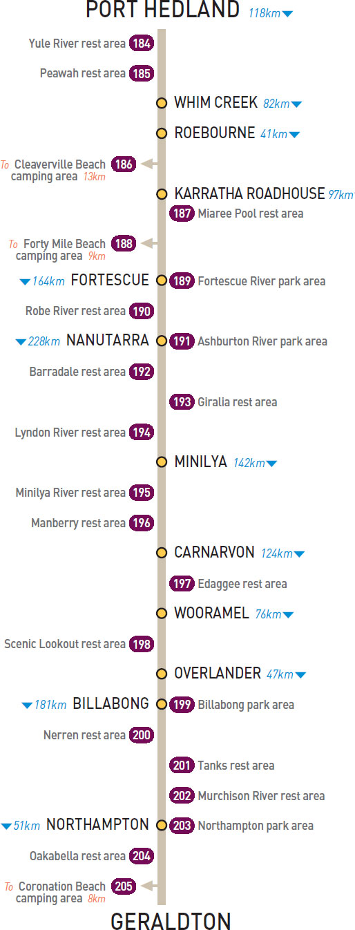
62km SW of Port Hedland (R) or 56km NE of Whim Creek (L)
Just off the highway among a few trees.
| GPS: S20 42.020 E118 17.938 | MAP: G1, C2, C12 |
92km SW of Port Hedland (R) or 26km NE of Whim Creek (L)
Just off the highway on a riverbank.
| GPS: S20 50.913 E118 04.085 | MAP: G1, C2, C12 |
T/O 13km W of Roebourne (R) or 28km E of Karratha Roadhouse (L)
On the foreshore 13km (unsealed) north of the highway. Camping is permitted May to Sept only.
| GPS: S20 39.673 E116 59.879 | MAP: E1, B2, B12 |
20km SW of Karratha Roadhouse (L) or 77km N of Fortescue (R)
Well off the highway on the banks of the Maitland River.
| GPS: S20 51.244 E116 36.787 | MAP: E1, B2, B12 |
T/O 41km S of Karratha Roadhouse (R) or 56km N of Fortescue (L)
Among dunes 9km (unsealed) west of the highway. Camping permitted Apr to Oct only.
| GPS: S20 50.833 E116 21.067 | MAP: E1, A2, A12 |
At Fortescue
Overlooking the river and opposite the roadhouse.
| GPS: S21 17.668 E116 08.510 | MAP: E2, A3 |
44km S of Fortescue (R) or 120km N of Nanutarra (L)
Just off the highway under a few trees on the riverbank.
| GPS: S21 36.903 E115 55.357 | MAP: D2, A3 |
At Nanutarra
Small area on the banks of the Ashburton River. Adjacent to the roadhouse.
| GPS: S22 32.583 E115 29.987 | MAP: D4, A5 |
72km S of Nanutarra (R) or 156km N of Minilya (L)
Well off the highway on the banks of the Yannarie River.
| GPS: S22 51.822 E114 57.242 | MAP: C4 |
110km SW of Nanutarra (L) or 118km NE of Minilya (R)
Just off the highway.
| GPS: S22 58.960 E114 36.823 | MAP: C4 |
179km SW of Nanutarra (R) or 49km NE of Minilya (L)
Just off the highway among trees on the riverbank.
| GPS: S23 29.057 E114 16.588 | MAP: C5 |
1km S of Minilya (R) or 141km N of Carnarvon (L)
Just off the highway among trees on the riverbank.
| GPS: S23 49.066 E114 00.631 | MAP: B6 |
50km S of Minilya (R) or 92km N of Carnarvon (L)
Just off the highway among a few trees.
| GPS: S24 15.004 E114 02.213 | MAP: C6 |
81km S of Carnarvon (L) or 43km N of Wooramel (R)
Just off the highway in the scrub.
| GPS: S25 27.558 E114 03.502 | MAP: C8 |
25km S of Wooramel (R) or 51km N of Overlander (L)
Well off the highway on top of a small plateau.
| GPS: S25 59.138 E114 17.899 | MAP: C8 |
At Billabong
Just off the highway among a few trees. Opposite the roadhouse.
| GPS: S26 48.989 E114 36.893 | MAP: D10 |
46km S of Billabong (R) or 135km N of Northampton (L)
Just off the highway among a few trees.
| GPS: S27 12.714 E114 36.765 | MAP: D10 |
70km S of Billabong (L) or 111km N of Northampton (R)
Well off the highway surrounded by scrub. Located at a tank site.
| GPS: S27 24.838 E114 40.015 | MAP: D10, A1, O6, A12 |
120km S of Billabong (L) or 61km N of Northampton (R)
Well off the highway among trees on the riverbank.
| GPS: S27 49.683 E114 41.309 | MAP: D11, A2, A12 |
At Northampton
Adjacent to the highway. In the middle of town.
| GPS: S28 20.911 E114 37.842 | MAP: D12, A3 |
17km S of Northampton (R) or 34km N of Geraldton (L)
Small area just off the highway among a few trees.
| GPS: S28 28.525 E114 38.074 | MAP: D12, A3 |
T/O 24km S of Northampton (R) or 27km N of Geraldton (L)
On the foreshore 8km west of the highway.
| GPS: S28 33.135 E114 33.881 | MAP: D12, A3 |