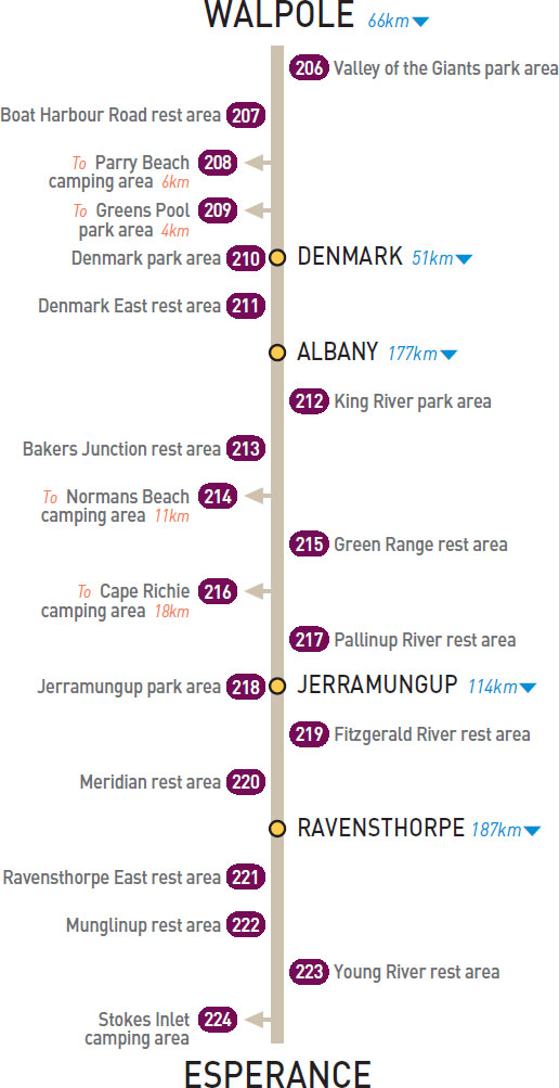
14km E of Walpole (L) or 52km W of Denmark (R)
Just off the highway among tall trees.
| GPS: S34 59.593 E116 51.659 | MAP: E12, D11 |
40km E of Walpole (R) or 16km W of Denmark (L)
Secluded behind bushes and trees.
| GPS: S34 59.470 E117 06.476 | MAP: F12, D11 |
T/O 43km E of Walpole (R) or 23km W of Denmark (L)
On the foreshore among dense coastal vegetation 6km south of the highway.
| GPS: S35 02.375 E117 09.596 | MAP: F12, D11 |
T/O 52km E of Walpole (R) or 14km W of Denmark (L)
On the foreshore in William Bay National Park. Located 4km south of the highway via William Bay Rd.
| GPS: S35 01.376 E117 14.133 | MAP: F12, D11 |
At Denmark
Just off the highway on the banks of a river.
| GPS: S34 57.610 E117 21.388 | MAP: F11, E11 |
7km E of Denmark (R) or 44km W of Albany (L)
Just off the highway among a few trees.
| GPS: S34 58.147 E117 25.413 | MAP: F11, E11 |
11km NE of Albany (R) or 167km SW of Jerramungup (L)
Small area just off the highway among some large trees on the banks of the river.
| GPS: S34 56.343 E117 54.261 | MAP: G11, E11 |
14km E of Albany (L) or 164km W of Jerramungup (R)
Just off the highway behind trees and bushes.
| GPS: S34 55.451 E117 55.510 | MAP: G11, E11 |
T/O 38km NE of Albany (R) or 140km SW of Jerramungup (L)
Very small area on the foreshore, 11km (partly unsealed) east of the highway.
| GPS: S34 55.280 E118 12.869 | MAP: H11, E11 |
73km NE of Albany (L) or 105km SW of Jerramungup (R)
Just off the highway among some trees.
| GPS: S34 37.698 E118 22.820 | MAP: H10, F11 |
T/O at Wellstead
In a natural bush setting on the foreshore 18km (unsealed) south-east of the highway.
| GPS: S34 35.867 E118 45.014 | MAP: F11 |
114km NE of Albany (L) or 64km SW of Jerramungup (R)
Just off the highway among some trees.
| GPS: S34 24.403 E118 43.671 | MAP: F10 |
At Jerramungup
Adjacent to the highway. On the north side of town.
| GPS: S33 56.393 E118 55.257 | MAP: F10 |
34km NE of Jerramungup (L) or 80km SW of Ravensthorpe (R)
Just off the highway among some trees.
| GPS: S33 49.908 E119 15.208 | MAP: F9 |
110km NE of Jerramungup (R) or 4km W of Ravensthorpe (L)
Large area just off the highway among some trees. Limited shade.
| GPS: S33 34.449 E120 00.000 | MAP: G9 |
6km E of Ravensthorpe (R) or 182km W of Esperance (L)
Just off the highway among some trees.
| GPS: S33 34.217 E120 06.417 | MAP: G9 |
At Munglinup
Just off the highway and opposite the roadhouse.
| GPS: S33 42.267 E120 51.629 | MAP: H9 |
99km E of Ravensthorpe (L) or 89km W of Esperance (R)
Just off the highway near the tree line.
| GPS: S33 45.806 E121 02.835 | MAP: H9 |
T/O 107km E of Ravensthorpe (R) or 81km W of Esperance (L)
Sheltered in scrub on the foreshore 6km (unsealed) south of the highway in Stokes National Park.
| GPS: S33 48.993 E121 08.965 | MAP: H9 |