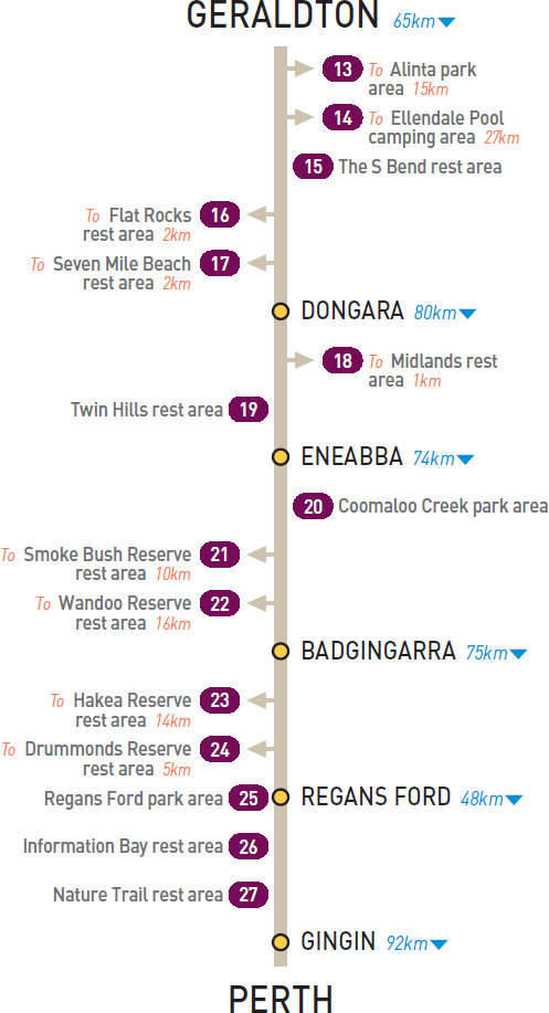
T/O 28km S of Geraldton (L) or 37km N of Dongara (R)
At the wind farm lookout, 15km east of the highway on the road to Ellendale.
| GPS: S28 54.235 E114 53.308 | MAP: D12, A3 |
T/O 28km S of Geraldton (L) or 37km N of Dongara (R)
On the banks of the Greenough River, 27km east of the highway via Walkaway.
| GPS: S28 51.552 E114 58.396 | MAP: E12, A3 |
29km S of Geraldton (L) or 36km N of Dongara (R)
Just off the highway among a few trees.
| GPS: S28 58.533 E114 47.034 | MAP: D12, A3 |
T/O 33km S of Geraldton (R) or 32km N of Dongara (L)
On the foreshore 2km west of the highway.
| GPS: S29 00.766 E114 46.731 | MAP: A3 |
T/O 55km S of Geraldton (R) or 10km N of Dongara (L)
On the foreshore 2km west of the highway.
| GPS: S29 10.181 E114 53.336 | MAP: A4 |
T/O 7km SE of Dongara (L) or 73km N of Eneabba (R)
Among a few trees 1km east of the highway via Midlands Rd.
| GPS: S29 15.301 E115 00.819 | MAP: A4 |
49km S of Dongara (R) or 31km N of Eneabba (L)
Just off the highway among a few trees.
| GPS: S29 34.700 E115 08.151 | MAP: A4 |
51km S of Eneabba (R) or 23km N of Badgingarra (L)
Well off the highway among trees at the turn-off to Jurien Bay.
| GPS: S30 13.466 E115 24.020 | MAP: A1, B5 |
T/O 51km S of Eneabba (R) or 23km N of Badgingarra (L)
On Jurien Rd, 10km west of the highway.
| GPS: S30 13.486 E115 17.833 | MAP: A1, B5 |
T/O 51km S of Eneabba (R) or 23km N of Badgingarra (L)
On Jurien Rd, 16km west of the highway.
| GPS: S30 13.454 E115 14.268 | MAP: A1, B5 |
T/O 13km S of Badgingarra (R) or 62km N of Regans Ford (L)
Off Bibby Rd, 14km west of the highway and near the wind farm.
| GPS: S30 27.613 E115 19.918 | MAP: A2, B5 |
T/O 13km S of Badgingarra (R) or 62km N of Regans Ford (L)
In scrub off Bibby Rd, 5km west of the highway.
| GPS: S30 29.297 E115 26.090 | MAP: A2, B5 |
At Regans Ford
Just off the highway under shady trees. Opposite the roadhouse.
| GPS: S30 59.208 E115 42.307 | MAP: B3, B6 |
3km S of Regans Ford (R) or 45km N of Gingin (L)
Secluded behind trees just off the highway.
| GPS: S31 00.100 E115 42.585 | MAP: B3, B6 |
11km S of Regans Ford (R) or 37km N of Gingin (L)
Secluded behind trees just off the highway.
| GPS: S31 03.848 E115 44.619 | MAP: B3, B6 |