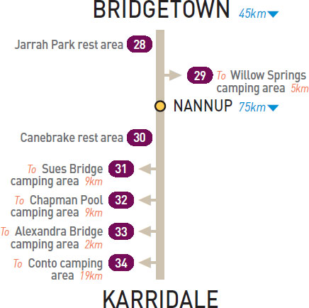
21km W of Bridgetown (R) or 24km E of Nannup (L)
Small secluded area in the forest.
| GPS: S34 01.843 E115 59.137 | MAP: C10, C10 |
T/O 24km W of Bridgetown (L) or 21km E of Nannup (R)
Secluded in the forest 5km (unsealed) south of the highway via Wetherley and Gold Gully rds.
| GPS: S34 02.745 E115 55.553 | MAP: C10, C10 |
34km W of Nannup (R) or 41km E of Karridale (L)
Just off the highway in the forest.
| GPS: S34 09.348 E115 31.116 | MAP: C10, C10 |
T/O 45km W of Nannup (R) or 30km E of Karridale (L)
Secluded in the forest 9km north of the highway via Sues Rd.
| GPS: S34 04.638 E115 23.293 | MAP: B10, B10 |
T/O 64km W of Nannup (R) or 11km E of Karridale (L)
Secluded bush setting 9km north of the highway via Warner Glen Rd.
| GPS: S34 05.329 E115 12.722 | MAP: B10, B10 |
T/O 64km W of Nannup (R) or 11km E of Karridale (L)
On a riverbank 2km north-west of the highway via Clarke Dr.
| GPS: S34 09.808 E115 11.046 | MAP: B10, B11 |
T/O at Karridale
Whistlers Way campsite is located 19km north-west of the highway via Bushby, Caves and Conto rds. It’s in a secluded bushland setting near the coast in Leeuwin-Naturaliste National Park. Other campsites available. Only Whistlers Way campsite suitable for large vans.
| GPS: S34 04.958 E115 00.839 | MAP: B10, B10 |