
Google Earth is the perfect backdrop for telling the story of 360 Degrees Longitude. This book has a Google Earth companion on the Web that will enhance the story as it unfolds. Google Earth is free, but it does require a broadband Internet connection to run properly.
Verify that you have a computer, with any modern Internet browser.

Check that you have a broadband Internet connection. This usually means a cable modem or DSL. Sorry, but a dial-up connection will result in little more than frustration. Google Earth is made up of terabytes of data, and while you don’t need to access all of that data at once, you will need to process a couple of megabytes per second to enjoy all there is to offer.

Download Google Earth, at http://earth.google.com

Get the 360 Degrees Longitude Google Earth companion file at http://www.360degreeslongitude.com/concept3d/360degreeslongitude.kmz and save it.
Throughout the book you will see the Google Earth logo ![]() when there is more information for you to find online. Want to visit the pampas where Katrina and Jordan fed piranha to Plastico the pet alligator? Fire up Google Earth, spin the digital globe to Bolivia, and drill down to Rurrenabaque and click the icon. That will pull up additional information about Rurrenabaque, along with photos and video taken in the area.
when there is more information for you to find online. Want to visit the pampas where Katrina and Jordan fed piranha to Plastico the pet alligator? Fire up Google Earth, spin the digital globe to Bolivia, and drill down to Rurrenabaque and click the icon. That will pull up additional information about Rurrenabaque, along with photos and video taken in the area.
If you are unfamiliar with Google Earth, here are a few basic steps that will help you get started.
Google Earth comes with several “layers” that you can turn on and off. There is a layer for international borders, a layer for populated places, a layer for bus stops, one for ATMs, and so on. The 360 Degrees Longitude companion file is simply another layer.
If you turn on all the layers simultaneously, the digital globe can quickly become overwhelmed, so explore the different layers that come with Google Earth to familiarize yourself with what’s available so you can turn them on and off as you see fit. One of my favorite layers is the terrain layer. With the terrain layer enabled you can see the texture of the surface of the earth when you zoom in and tilt the horizon.
Once you have the feel for how Google Earth behaves, download the layer for 360 Degrees Longitude. After the download is complete, Google Earth will automatically open and you should see something like this:
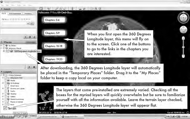
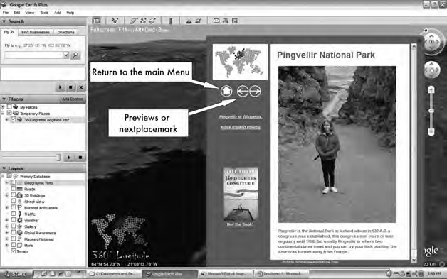
Clicking on one of the “Chapters” menu buttons (see above) opens a list of all the links from the book. Clicking on one of the links will open a dialogue box with photos, video, and text that describe events in that part of the world. For example, clicking on Chapters 0–4, then “Pingvellir” under Chapter 1 will open the dialogue box shown in below.
There are more features in the 360 Degrees Longitude layer explained in the online tutorial at http://www.360degreeslongitude.com/ge/ge_how2.pdf. If you have a question that isn’t covered in the online tutorial, send me an e-mail at john@360degreeslongitude.com. Enjoy!
Google™ and the Google Earth icon ![]() are registered trademarks of the Google corporation. Used by permission.
are registered trademarks of the Google corporation. Used by permission.