INFORMATION AND PERMITS: All backpackers must secure and pay for a wilderness permit for entry into Desolation Wilderness. The region is heavily used, and strict zone quotas are in place for the number of overnighters departing from every trailhead that enters the wilderness. A majority of permits are available by reservation, with the remainder handed out on a first-come, first-served basis. Reserved permits can be obtained online at recreation.gov. During business hours, walk-in permits may be picked up at the Taylor Creek Visitor Center, Pacific Ranger Station, Lake Tahoe Basin Management Unit (LTBMU) Supervisor’s Office, and LTBMU North Shore Office.
DRIVING DIRECTIONS: Follow CA 89 on the west shore of Lake Tahoe to Meeks Bay and locate the trailhead near a closed gate on the west side of the highway, 0.1 mile north of the entrance into Meeks Bay Campground. The trailhead is approximately 16.5 miles north of the junction of CA 89 and US 50 in South Lake Tahoe or 11 miles south of the junction of CA 89 and CA 28 in Tahoe City.
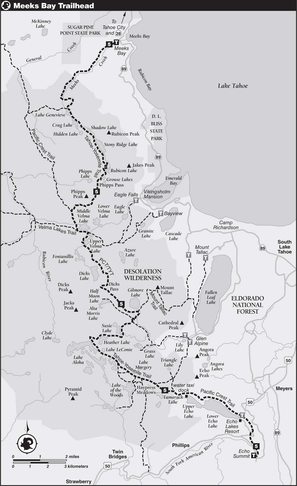
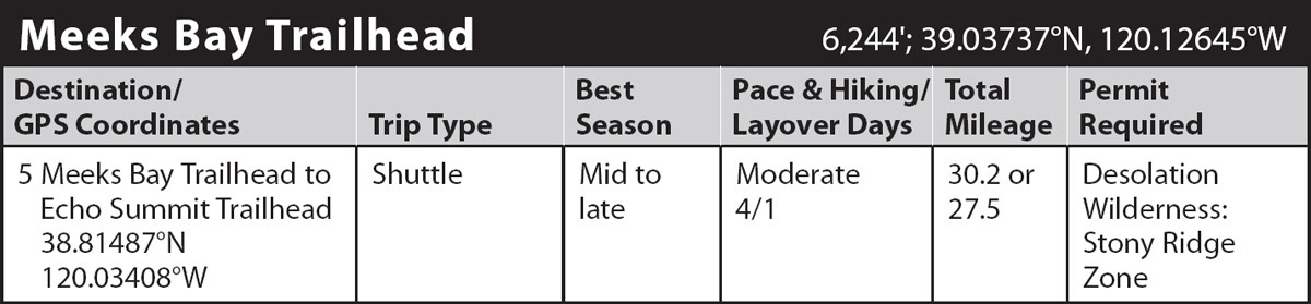
trip 5 Meeks Bay Trailhead to Echo Summit Trailhead
Trip Data: |
38.81487°N, 120.03408°W; 30.2 or 27.5 miles; 4/1 days |
Topos: |
Homewood, Rockbound Valley, Pyramid Peak, Echo Lake |
HIGHLIGHTS: This first section of the unofficial Tahoe-Yosemite Trail (TYT), from Meeks Bay to Adventure Mountain Lake Tahoe, a winter recreation area just west and south of US 50’s Echo Summit, lies almost entirely within one of California’s best-known wilderness areas, Desolation. The section is never far from a road, and frequent glimpses of Lake Tahoe may call forth images of noisy casinos and crowded beaches. Yet near the trail you may find many campsites that feel utterly remote.
HEADS UP! Extensive sections of the trail are strewn with sharp, angular rock—be sure to wear sturdy footwear. Wood fires are banned within the wilderness, so plan on using a stove for cooking. Bear canisters are strongly recommended.
SHUTTLE DIRECTIONS: Follow US 50 to Echo Summit, and from there go west to a paved access road on the south side of the highway, 0.2 mile west of Echo Summit. A sign for Adventure Mountain Lake Tahoe resort marks the turnoff. Proceed 0.2 mile to the large Pacific Crest Trail (PCT) parking lot just before the resort.
DAY 1 (Meeks Bay Trailhead to Rubicon Lake, 8.0 miles): The “trail” begins as a dirt road beyond a locked gate near CA 89. The gate bars access to the general public, but vehicles may still be infrequently encountered along the road. Beyond the gate, head generally southwest through mixed forest of incense cedars, white firs, lodgepole pines, and sugar pines on the right, and verdant meadows along Meeks Creek on the left. Continue along the dusty road to a junction about 1.5 miles from the trailhead.
Obeying signed directions for the Tahoe-Yosemite Trail, turn right (southwest) and leave the road behind to follow a climbing singletrack trail past luxuriant foliage bordering a seeping spring to the signed Desolation Wilderness boundary, 2.5 miles from the trailhead.
A moderate ascent on rocky trail continues and leads past a spring surrounded by thriving currant bushes and corn lilies. Above the spring, purple lupine and red paintbrush carpet the slope. Beyond the spring, the grade eases, and mountain junipers start to line the path.
MOUNTAIN JUNIPERS
These rugged trees with thick, sienna-barked trunks are members of the cypress family, very unlike the more common needle-bearing conifers of the High Sierra. Botanists consider junipers to be more closely related to incense cedars, also members of the cypress family. The twigs of junipers, incense cedars, and giant sequoias (not in the cypress family) are covered with overlapping scalelike leaves rather than needlelike leaves that extend from the twig as do the pines, firs, and spruces.
Nearing Meeks Creek, the sound of the gurgling stream delights passersby. Along the banks of a seep beside the creek, paintbrush, monkeyflower, columbine, and tiger lily blossom in early summer. Veering away from the stream, the sandy, now-level tread passes through a meadow and then a forested meadow glade of ferns before encountering another meadow holding a forest of drowned trees, bare and silvery in death. The large yellow flowers from a garden of mule ears soften the bleak ambiance created by the dead trees. A gentle-to-moderate ascent under sparse, mixed forest cover gives way to a short, moderate-to-steep climb on rocky trail, where red fir joins the other conifers.
RED FIRS
Sometimes referred to as silvertips, red firs are found between 5,000 and 9,000 feet in California, although they are most common around 7,000 and 8,000 feet. In fully developed stands, very little groundcover is found due to the lack of sunlight reaching the forest floor. Saprophytes—plants that don’t perform photosynthesis, such as snow plant and pine drops—may be found randomly thrusting out of the shady soil.
Near a sturdy log-and-timber bridge over Meeks Creek is an attractive campsite—unfortunately, its close proximity to the creek makes the site illegal for camping. However, across the bridge and 80 yards upstream is a shady campsite that’s suitable for overnight stays. Nearby, pan-size brook and brown trout lie in small holes shaded by thickets of dogwood, alder, willow, and mountain ash.
The sandy trail steadily ascends the east wall of the canyon, looping away from the creek to gain the height of a steep cascade, as the gracefully curved tips of mountain hemlocks herald your arrival in the higher elevations. Just beyond a waterfall, the trail leads to a junction with the seldom-used Lake Genevieve Trail and then soon reaches the shore of Lake Genevieve, a shallow, warm, pine-rimmed, green lake. A few fair campsites at the north end and along the east side provide views across the water of photogenic Peak 9,054, a beautiful sight in early morning with sunrise light crowning a mantle of blue shadows. Campsites at Genevieve and the upcoming lakes are limited and are generally fair to poor in quality. With the canyon’s floor shoehorned between steep ridges, the campsites are sandwiched tightly between the trail and the shorelines.
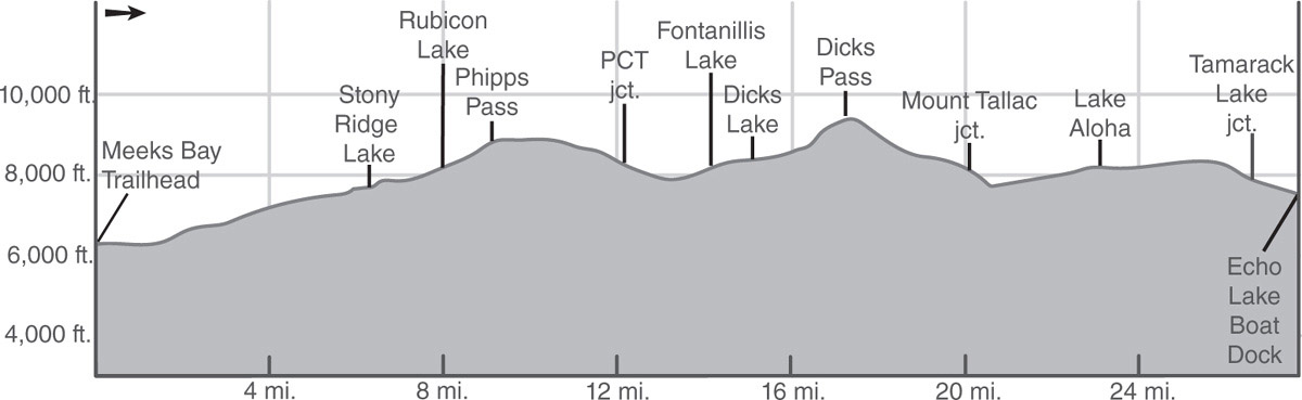
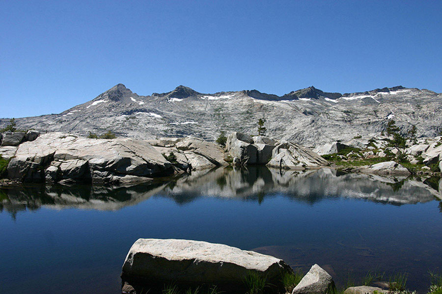
Scenic Crag Lake in Desolation Wilderness Photo by Mike White
From Lake Genevieve the trail makes a short, gentle ascent under red fir, western white pine, and Jeffrey pine to Crag Lake, where fair campsites on the glacial moraine forming the east side of the lake’s basin may tempt overnighters.
DAMS
The flow-maintenance dam across Crag Lake’s outlet is one of many such dams in the high country built by the state’s Department of Fish and Game (DF&G), U.S. Forest Service, or private sportsmen’s groups. DF&G biologists and wardens making adjustments of the outlet valve during the summer ensure adequate flow continues into Meeks Creek.
The route now ascends moderately on rocky tread to a ford of Meeks Creek. Just beyond the ford is a junction with a path right (south) and down to Hidden Lake, which appears through gaps in the forest a short distance farther up the trail. Despite increasing use and subsequent fishing pressure, Hidden Lake seems to maintain a healthy population of brook trout.
Go ahead (southeast) here, veering away from the creek, to make a gentle ascent through dense pine forest that passes above meadow-bordered and lily-dotted Shadow Lake. Make a steady diagonal ascent up a curving moraine, beside rapids and cataracts, to Stony Ridge Lake, the largest of the six Tallant Lakes occupying this valley, 6.3 miles from the trailhead. Backpackers will find fair campsites near the outlet, as well as a few along the west shore. Anglers can test their skills on both rainbow and brown trout. A forest primarily of lodgepole pines rims the lake except along the eastern shore. A short distance up the rocky western slope, gray-green sagebrush calls into question the notion that sagebrush defines desert.
At the head of Stony Ridge Lake, make a slight ascent overlooking a pond and a green, marshy meadow above the lake. For the next half mile, the trail is mostly level across a wet hillside carpeted by the best flower gardens seen so far on the TYT. After a 300-foot elevation gain via a series of switchbacks, the trail turns south, paralleling the east side of a small, north-facing glacial cirque. Black, lichen-streaked cliffs stand 200 feet high above a talus-block fan. In early season, the wide, sweeping snowbank in this cirque, stained red by millions of minute algae, is a small reminder of the glacier that sculpted the curving headwall.
Eight miles from the trailhead you find Rubicon Lake (8,277'; 38.96675°N, 120.13523°W), the crown jewel of the Tallant Lakes. Encircled by lodgepole pines and mountain hemlocks, the green-tinted lake offers a number of fair-to-good campsites scattered around its shoreline.
DAY 2 (Rubicon Lake to Dicks Lake, 7.1 miles): About 100 yards up the cool, shaded trail from Rubicon Lake is a lateral on the left to Grouse Lakes. The TYT goes right (ahead, south) here, and, after a couple of switchbacks, the snow-covered north slope of Mount Tallac springs into view above the gray-green valley of Eagle Creek.
On rocky trail, ascend moderately until the grade eases on a traverse of the far side of a ridge overlooking Grouse Lakes and the Eagle Creek drainage, along which Cascade and Fallen Leaf Lakes are visible to the southeast. Where the route to Phipps Lake departs to the right (west), the TYT continues ahead (south-southwest) as the traverse is interrupted by a set of steps of milled lumber held in place by steel pegs. For some unclear reason, the next section of trail contours around the south side of Phipps Peak until it heads almost due north, at which point hikers might begin to worry, knowing that they should be heading south toward the Velma Lakes. Ultimately, they will.
Dicks Peak comes into view near Phipps Pass, and some of the mountains of the Crystal Range appear over its right shoulder. You’ve been traveling through gray granite country since the beginning of the journey; now, the reddish-brown metasedimentary rocks of Dicks Peak and outliers are quite striking. Leaving the pass, the trail descends briefly but over the next half mile seems to climb more often than drop.
Soon, all three Velma Lakes come into view at once. Named for a daughter of Nevada mining king Harry Comstock, the lakes lie close together in a single basin—but Upper and Lower Velma Lakes drain into Lake Tahoe and ultimately Nevada’s Pyramid Lake, while Middle Velma Lake drains into the Rubicon River and ultimately the Pacific Ocean. From this vantage point, experienced cross-country enthusiasts may elect to head straight for Middle Velma Lake, as the TYT route is quite indirect.
Veering west onto Phipps Peak’s dry and exposed west flank, the TYT provides excellent views of the north part of the Crystal Range, including Rockbound Pass—the deepest notch visible—and the basins of Lakes Lois and Schmidell, landmarks that remain visible for a mile or more as the trail arcs around Phipps Peak. Finally, at a hairpin turn, the trail heads back toward Velma Lakes. A few yards northwest of this turn, a viewpoint overlooks much of Rockbound Valley, including the namesake lake, which sits near the wilderness’s northwest corner. Beyond this vista point, a steady, sandy descent incorporating three long switchbacks passes through moderate-to-dense forest cover to a junction with the 2,600-mile PCT, 4 miles from Rubicon Lake.
Turn left (south-southeast) onto the southbound PCT. From the PCT junction to Middle Velma Lake, the route wanders more than seems necessary, eventually crossing a sluggish creek to reach the first of two junctions with the Velma Lakes Trail, which here heads right (generally west) to Camper Flat on the Rubicon River. The PCT/TYT, briefly joined by the Velma Lakes Trail, goes left (generally east) at this junction. At the southwest end of forested Middle Velma Lake, the PCT/TYT skirts a cove and rises above the lake into red fir forest.
The shady duff tread of the PCT/TYT soon leads to the second junction with the Velma Lakes Trail, which here goes left (east) while the PCT/TYT goes right (generally south). (To visit Upper Velma Lake, make a 200-yard stroll up this trail to a junction marked by a post and turn south, reaching the southwest shore of the lake after another half a mile. Backpackers will find fair campsites near the inlet.)
POCKET GOPHER TUNNELS
In a meadow of sedge and corn lilies, where the trail first nears Upper Velma Lake, “ropes” of soil are the telltale signs of the pocket gopher. During the winter, the rodent tunnels in the snow to eat the aboveground parts of plants. Later, the gopher tunnels in the earth, filling the snow tunnels with the extracted dirt. Following snowmelt, these casts of dirt that once filled snow tunnels descend to the ground, where you see them.
From the second Velma Lakes Trail junction, the PCT/TYT ascends south on a moderate grade while overlooking Upper Velma Lake. As the slope eases to gentle, Dicks Pass, Lake Tahoe, and then Fontanillis Lake come into view. After a short, gentle descent, cross the outlet and reach Fontanillis Lake, cradled in a rocky basin and towered over by Dicks Peak. Fair campsites are shaded by stands of lodgepole pines and mountain hemlocks. On the east shore, a lavish display of red and sienna rocks complements the familiar gray granite—scramble up the slope to find them.
Leaving Fontanillis Lake, the sandy trail ascends a boulder-covered granite hillside with several meltwater tarns that could offer a refreshing swim at just the right time of the season. At the top of this rise, there’s a junction where a short lateral heads right (south) to Dicks Lake (8,429'; 38.91616°N, 120.14561°W). This cirque lake below Dicks Peak offers several fair campsites and one good one on the timbered east shore. Anglers will appreciate a self-sustaining population of brook trout.
DAY 3 (Dicks Lake to Tarn Above Heather Lake, 7.4 miles): At the junction of the PCT/TYT and the Dicks Lake lateral, the PCT/TYT turns north (left if you’ve not gone down to Dicks Lake, right if you are coming from the lake) and proceeds a short distance to another junction in a saddle overlooking the drainage of Eagle Creek to the east. Turn right (southeast) here as the rocky trail ascends steadily on a granite slope sparsely dotted with lodgepole pines. Far below, a large area of downed timber on the southwest slope of the Dicks Lake cirque provides graphic evidence of a former avalanche.
The grade increases as more than a dozen switchbacks assault the northwest slope of Peak 9,579, which often remains snow covered into July. The ascent concludes at Dicks Pass (9,380'), which is somewhat east of the actual low point of the divide. Standing at the pass with pack off and shoulders recuperating, the backpacker surveys a considerable part of California, from Sierra Buttes beyond Yuba Pass in the north to Round Top beyond Carson Pass in the south. Nearer to the south, Pyramid Peak rises majestically above island-dotted Lake Aloha, and from just beyond the pass, Susie and Grass Lakes are clearly seen in the wooded basin of Glen Alpine Creek. The trail sign at the pass stands at the center of several almost flat acres, strewn with the rocky products of erosion. The surrounding trees are all whitebark pines, the highest-dwelling conifer encountered along the TYT. When snowmelt provides a reliable source of water, good campsites provide an overnight haven east of the pass.
Descending from the pass to the actual saddle, Susie, Gilmore, and Half Moon Lakes and Lake Aloha can be seen ahead, while Fontanillis and Dicks Lakes are visible to the rear. The trail descends the warm, south-facing slope, and when there is still much snow on the north side, the south side offers a springtime display of vibrant wildflowers, including paintbrush, sulfur flower, white heather, western wallflower, white and lavender phlox, and elderberry. At the saddle on this divide, a use trail provides access westward to the summit of Dicks Peak.
Go left (southeast) here to stay on the PCT/TYT as it traverses gently down the side of a ridge toward Gilmore Lake. Along this traverse, the variety of wildflowers seems to multiply with each step. At the peak of the blossoming season, delphinium, deer brush, spiraea, creamberry, red heather, buckwheat, groundsel, serviceberry, corn lily, penstemon, white heather, pussypaws, and buttercups will delight passersby. Near the first sign of red firs, a lateral heads left (northeast) a short way to Gilmore Lake, where backpackers will find good campsites and anglers can test their skill on three species of trout. For peak baggers, the trail to Gilmore Lake continues toward the 9,735-foot, view-packed summit of Mount Tallac.
The PCT/TYT goes right (ahead, east) at the junction to begin a switchbacking descent through mixed forest to a junction where a trail on the right heads north to Half Moon Lake and a trail to the left goes east-southeast to Glen Alpine. You go ahead (southwest) on the PCT/TYT down rocky trail toward Susie Lake for a half mile to a swampy, flower-filled meadow and a junction with another trail left (south) to Glen Alpine and Fallen Leaf Lake. Go right (west-southwest) and make a short, moderate, winding ascent that culminates at a rise overlooking Susie Lake, one of the most popular lakes in Desolation Wilderness, despite the poor-to-fair campsites. After crossing the outlet, a difficult ford in early season, the PCT/TYT meets a use trail heading down the canyon to large, forested campsites.
Staying on the PCT/TYT, curve right (southwest) to continue around the shore of Susie Lake and then climb steadily up to the V at the outlet of the Heather Lake basin, formed by the slopes of Jacks Peak on the north and Cracked Crag on the south. (In early season there is always snow here.) Notice the clear line of division on Jacks Peak that separates the metasedimentary rock of the “Mount Tallac pendant” and the gray granite to the south. Follow a rocky course well above Heather Lake over a small ridge and then just above a placid tarn. Although Heather Lake offers no decent, legal places to camp, good campsites can be found beside a tarn (8,022'; 38.87756°N, 120.14490°W) that lies just below the headwall of the lake’s cirque. This is the better place to stop, as upcoming Lake Aloha is extremely windy and has almost no decent, legal campsites. Heather Lake has rainbow, brook, and brown trout.
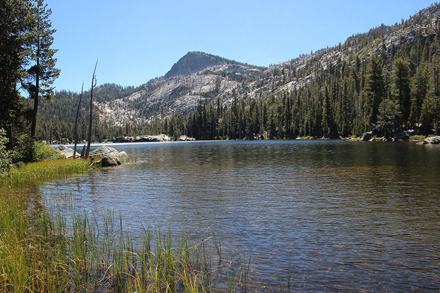
Aloha Lake Photo by Mike White
DAY 4 (Tarn Above Heather Lake to Echo Summit, 7.7 miles or 5.0 miles via water taxi): A short, rocky climb leads to the crest of the divide that separates the Heather Lake basin and Desolation Valley. This high point offers a magnificent, close-up view of the Crystal Range.
CRYSTAL RANGE
Rising above the far shore of shallow, island-dotted Lake Aloha, this classic range is a superb glacial ridge left standing high after moving ice on both sides plucked immense quantities of rock from its flanks and carried them downslope. Parts of the ridge are knife edged—which geologists call an arête—and snowfields at the base of the knife blade look like little glaciers.
Foregrounding Mount Price, Pyramid Peak, and the peaks between is a blue sheet of water, Lake Aloha, which is more than 2 miles long and dotted with a thousand tiny granite islands, some of which harbor a single weather-beaten lodgepole snag. Campsites at Lake Aloha are very few, very poor, and very windy. However, some will find camping near the lake worthwhile for the sight of the morning sun turning the Crystal Range from blue-gray to gold.
Nearing the northeast edge of Lake Aloha, the trail to Mosquito Pass and Rockbound Valley heads right (west), but the PCT/TYT veers left (southeast) to follow the shore of the lake, composed of glacier-polished, barren granite. After 0.5 mile the trail turns and immediately comes to a flat, where an unsigned and little-used spur darts left (north) to Lake Le Conte. This lake has several small, fair campsites on the east side. The PCT/TYT goes right and continues southeast around Lake Aloha’s shore.
DESOLATION VALLEY
Even in this “desolation valley,” formerly called Devils Basin, life is plentiful. Coyotes are often heard and sometimes seen, and yellow-bellied marmots virtually infest the talus slopes of Cracked Crag. Water snakes and skinks fill their ecological niches. Lake Aloha itself has thousands of brook and rainbow trout. Wildflowers abound, and besides lodgepole pine, conifers include mountain hemlock, western white pine, red fir, and junipers.
Approaching sparse forest cover, as stands of lodgepole pine alternate with meadows, the PCT/TYT goes left (southeast) at a junction with a trail straight ahead (south) to Lake of the Woods. After a short ascent, the trail enters a highly scenic area, where, in early to midseason, numerous tarns reflect the green pines and hemlocks and the house-size gray boulders dumped here by the glacier. Near the westernmost tarn, a trail to Lakes Margery and Lucille leads off left (east) to good campsites around both lakes and to bearably warm swimming. The PCT/TYT goes right (southeast).
In a short quarter mile, a well-used spur trail from Lake Aloha merges with the TYT from the right, and 0.3 mile farther, the southern trail to Lake Lucille goes left (north). The excavated, level patch of ground next to the junction once held a log cabin used by trail crews and others needing emergency shelter. Go right (east-southeast) here to stay on the PCT/TYT.
The PCT/TYT next meets a pair of laterals that go right to Lake of the Woods, one in about 200 yards from the last junction and the other 350 yards farther on. Continue ahead (east-southeast) on the PCT/TYT at both junctions as the wide, sandy trail skirts above Haypress Meadows, site of one of the largest expanses of grass on the TYT. The grass was once harvested for sale to wagon trains crossing Echo Summit. Raised walkways help protect the fragile meadows from being trampled. As the PCT/TYT passes an abandoned trail, Echo Lakes come into view down the valley of Echo Creek, and the trail becomes steep and rocky. Where a trail veers left (east) up the hill toward Lily and Fallen Leaf Lakes, the PCT/TYT continues ahead (east-southeast) toward Echo Lakes. At the last switchback in a series, rocks to sit on, water, and shade provide a fine place for a rest stop.
Watch your footing on the next section, a long traverse down a moderately graded tread filled with loose granite rocks. Even though many day hikers and equestrians routinely travel this far from Echo Lakes, it’s hard to justify the extensive blasting and grading of this section of trail that many refer to as a freeway.
Go left (briefly northeast) at a junction with a lateral right (southwest) to Tamarack Lake (camping prohibited) and reenter forest: a heavy cover of lodgepole, later thinning somewhat and showing inclusions of Jeffrey pine. Beyond the forest, another unsigned trail to the Fallen Leaf Lake area goes left (north) up the hill as the PCT/TYT continues ahead (generally southeast). Exit Desolation Wilderness in 300 more yards and soon encounter the signed lateral going right to the water taxi landing at the north shore of Upper Echo Lake.
WATER TAXI
The Echo Lake Chalet offers water taxi service from the resort’s upper dock at the south end of Lower Echo Lake to the public dock at the far end of Upper Echo Lake, reducing the hiking distance by 2.5 miles. The normal season runs from the Fourth of July through Labor Day weekend, although service is usually extended through September, depending on weather conditions and lake levels. The fee in 2019 was $15 per person one-way with a three-person minimum for service. A direct-line phone to the Chalet at the upper dock can be used to arrange for pickup. (Visit their website, echochalet.net, or call 530-659-7207, 8 a.m.–6 p.m. during summer, for more information.)
Beyond the water taxi lateral, the trail skirts the north side of Upper and Lower Echo Lakes. The 2.5-mile walk is unremarkable on a wide and well-trod trail that travels discouragingly high above the lakes. The final section is on a dusty, exposed, south-facing slope, making the trip uncomfortably warm in the afternoon sun.
After a milkshake or other morale-booster at Echo Lake Resort, take a very steep trail from the back of the public restrooms next to the resort up to the large parking lot (an alternate end point if you want to skip the last 1.75 miles between the Echo Lake and Echo Summit Trailheads), and on the west edge of the paved lot, find a segment of PCT/TYT built in 1978. This segment first makes a long switchback leg west before turning east to climb gently through red firs above the many summer-home cabins. The trail veers south and then southwest and, just past a rusty tank on the left, meets a junction: Ahead is a 4WD road; turn left (southeast) to continue on the signed PCT. Immediately dip across a small seasonal stream and follow the trail on a gradual curve through white fir and lodgepole pine to meet paved Johnson Pass Road at a ditch so abrupt you may wish to cut left, almost to a driveway, to avoid it.
From the ditch intersection, angle right across the road toward PCT signs and continue gently winding down to meet US 50 about 100 yards east (uphill) of the defunct Little Norway Resort. Cross the highway and on the south side find the next section of trail, which crosses another ditch and turns left (south-southeast) to climb as it parallels the highway toward Echo Summit. After a mile, this section meets a paved road coming south from US 50. Turn right (south) onto the paved road and end your trip at a paved PCT trailhead parking lot (7,385'; 38.81487°N, 120.03408°W), south of which is an area that operates as Adventure Mountain Lake Tahoe resort in winter.