INFORMATION AND PERMITS: The area around Star Lake is administered by the Lake Tahoe Basin Management Unit: U.S. Forest Service, Lake Tahoe Basin Management Unit, 35 College Drive, South Lake Tahoe, CA 96150; 530-543-2600; fs.usda.gov/ltbmu. No wilderness permits are required, but you must have a California Campfire Permit to have a campfire or use a stove.
DRIVING DIRECTIONS: Take CA 89, south from the junction of US 50 in Meyers or north from Picketts Junction with CA 88, to Forest Service Road 051, which is 1.8 miles below Luther Pass. Follow the sometimes-rough dirt tread northwest for nearly 3.5 miles to an intersection with FS 051F on your left, which is blocked to traffic by large boulders (this intersection is immediately after the second bridge over Willow Creek). Park your vehicle along the roadside as space allows.
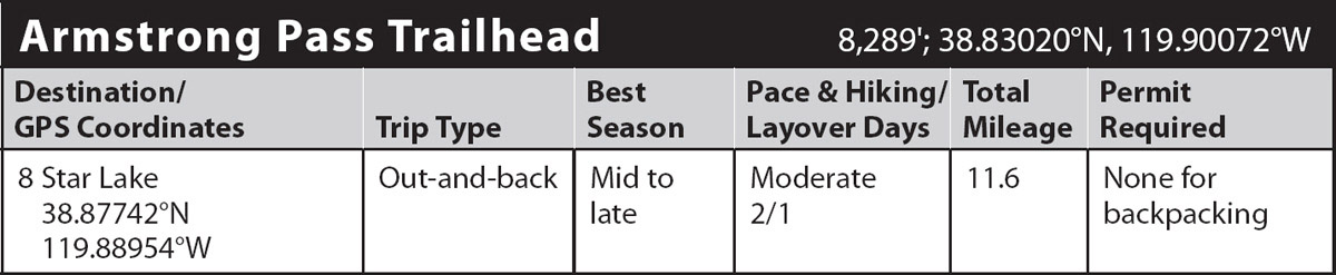
trip 8 Star Lake
Trip Data: |
38.87742°N, 119.88954°W; 11.6 miles; 2/1 days |
Topos: |
Freel Peak (trail not shown on map) |
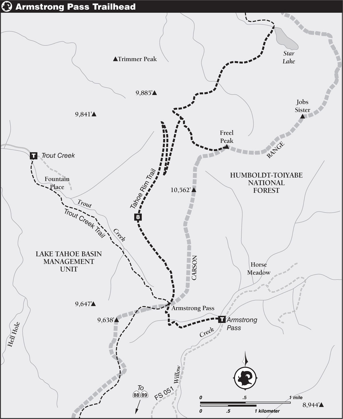
HIGHLIGHTS: Follow a section of the Tahoe Rim Trail (TRT) to Star Lake, the Tahoe Basin’s highest lake, if not for the much-less-impressive-looking Mud Lake on the northeast shore. Backdropped by volcanic slopes of rugged Jobs Sister, the lake is one of the area’s most beautiful. A layover day offers the opportunity to hike to the summit of Freel Peak, the highest peak in the basin at 10,881 feet.
DAY 1 (Armstrong Pass Trailhead to Star Lake, 5.8 miles): From the parking area, head west on the dirt road for 0.5 mile to a wide turnaround, where a TRT sign designates the beginning of singletrack trail. Climb moderately steeply, soon crossing a diminutive tributary of Willow Creek. Beyond the creek, switchbacks zigzag up a hillside covered with sagebrush, currant, and tobacco brush below widely scattered western white pines and junipers. The stiff climb abates a mile from the trailhead at the saddle of Armstrong Pass amid a light forest of red firs, where you reach a four-way junction with the Tahoe Rim and Trout Creek Trails.
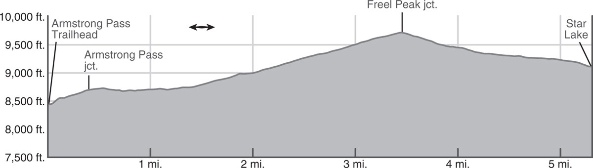
Turn right and follow the pleasantly graded TRT on a rising traverse below the west side of the Carson Range crest. You soon emerge from the forest onto mostly open slopes, dotted occasionally by a western white pine or juniper. Past the rock cliff known as Fountain Face, you have fine views of the Trout Creek drainage and the meadows below in Hell Hole and Fountain Place, as well as across the shimmering surface of Lake Tahoe to the Crystal Range towering over Desolation Wilderness. Continue the steadily rising traverse, hopping over a few tiny rivulets along the way. Just shy of 3.5 miles, the trail angles across the slope via the first of a pair of long-legged switchbacks. About 1.25 miles farther, the climb reaches a crescendo at 9,730 feet at the base of the northwest ridge of Freel Peak. Here, the trail to the summit veers off to the right.
The descent to Star Lake begins on a series of switchbacks leading to the floor of a cirque basin north-northwest of Freel Peak. From there, the trail makes a short, moderate drop through open forest to the crossing of a thin ribbon of water from a Cold Creek tributary. Beyond the stream, you follow a nearly mile-long traverse to the north ridge of Jobs Sister, followed by a short decline along the ridge to lovely Star Lake.
At 9,100 feet, Star Lake is not only one of the highest in the basin but also one of the coldest, although a chilly swim might be quite refreshing on a hot summer day. A number of overused campsites can be found along the shore, with ones above the lake possibly offering greater potential for solitude. Wherever you elect to set up your tent, the view across the water of Jobs Sister is never disappointing (9,155'; 38.87742°N, 119.88954°W).
If you choose to use a layover day for the ascent of Freel Peak, retrace your steps back to the junction at the base of the peak’s northwest ridge. Leaving the TRT behind for the time being, ascend sandy tread and rock steps on a switchbacking climb across the right side of the ridge below rock outcrops. After gaining the crest of the ridge, the route veers to the left on an angling ascent across the gravelly northwest face of the peak. Reaching the top, a marvelous 360-degree view of the greater Tahoe area unfolds.
Rather than simply retrace your steps to Star Lake, you could double summit by following the spine of the Carson Range a mile or so to 10,823-foot Jobs Sister. From there a straightforward descent along the northwest ridge leads back to the lake.
DAY 2 (Star Lake to Armstrong Pass Trailhead, 5.8 miles): Retrace your steps.