INFORMATION AND PERMITS: All backpackers must secure and pay for a wilderness permit for entry into Desolation Wilderness. The region is heavily used, and strict quotas are in place for the number of overnighters departing from every trailhead that enters the wilderness. A majority of permits are available by reservation, with the remainder handed out on a first-come, first-served basis. Reserved permits may be obtained online at recreation.gov. During business hours, walk-in permits may be picked up at the Taylor Creek Visitor Center, Pacific Ranger Station, LTBMU Supervisor’s Office, and LTBMU North Shore Office.
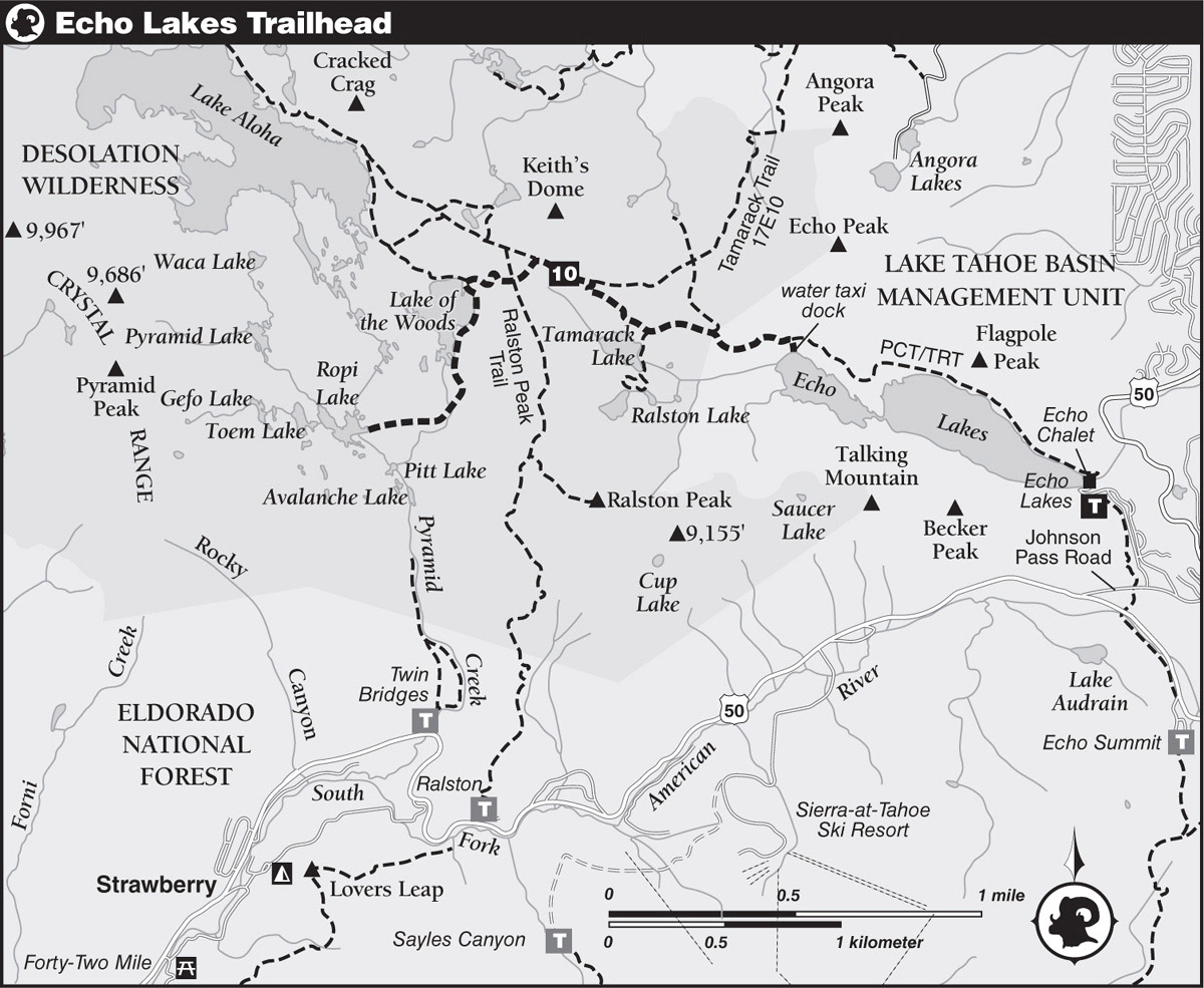
DRIVING DIRECTIONS: Follow US 50 toward Echo Summit. Turn east onto Johnson Pass Road, 1.25 miles westbound of the summit and 1.8 miles eastbound of the Sierra-at-Tahoe ski resort, and proceed 0.5 mile to a left turn onto Echo Lakes Road. Continue up this road another 0.9 mile to the large trailhead parking lot above the south shore of Lower Echo Lake.
trip 10 Ropi Lake
Trip Data: |
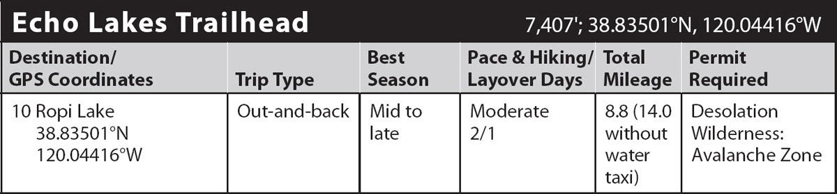
38.83501°N, 120.04416°W; 8.8 miles (14.0 without water taxi); 2/1 days |
Topos: |
Echo Lake |
HIGHLIGHTS: Numerous coves, islands, and campsites make Lake of the Woods a popular destination. The rest of Desolation Valley beyond is one of the most picturesque corners of Desolation Wilderness, where a sparkling granite, glacier-scoured basin holds a plethora of picturesque lakes and tarns, many of which are not accessible by developed and maintained trails, making the area a cross-country enthusiast’s dream. The beauty of the area is further highlighted by the majestic profile of Pyramid Peak towering over the basin.
HEADS UP! Taking the water taxi service from Echo Lake Chalet cuts off 2.5 miles of uninteresting hiking along the shoreline of Echo Lakes. The service typically runs from the Fourth of July through sometime in September, depending on weather conditions and suitable water levels. Check out the resort’s website for pricing and more information at echochalet.com.
DAY 1 (Echo Lakes Trailhead to Ropi Lake, 4.4 miles): Note: Without water taxi service, you will have to walk the extra 2.6 miles around the north shore of Echo Lakes and add that distance to the following mileages. From the water taxi pier at the north shore of Upper Echo Lake, climb up the trail to the junction with the Pacific Crest Trail (PCT)/Tahoe Rim Trail (TRT). Turn left and proceed on rocky tread across open slopes on a westbound course away from the lake. Near the Desolation Wilderness boundary, 0.7 mile from the pier, reach a junction with a lightly used trail heading north toward Triangle Lake. Travel another 0.4 mile to another junction, this one with a short lateral on the left to Tamarack, Ralston, and Cagwin Lakes. These pretty lakes are definitely worth a visit if you have the extra time and energy.
Beyond the junction, the PCT/TRT follows a moderate climb to a crossing of a diminutive rivulet coursing through a ravine. Then the trail continues up a pair of switchbacks to an open bench and a junction with Tamarack Trail 17E10 heading east, 1.1 miles from the pier.
Gently ascending trail leads along the northern fringe of the broad expanse of grassy Haypress Meadows, where early- to midsummer wildflowers put on a fine floral display. Near the far end of the meadows, at 2 miles, you reach your junction with the trail to Lake of the Woods.
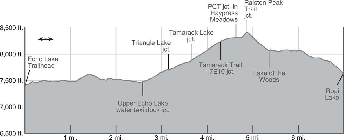
Leave the PCT/TRT and head southwest, skirting the edge of Haypress Meadows and climbing to the crest of a low ridge, where you intersect the Ralston Peak Trail.
Continue ahead, following a moderately steep switchbacking descent to a junction near the northwest shore of Lake of the Woods, 2.6 miles from the Upper Echo Lake pier. The aptly named, forest-rimmed lake offers visitors a peaceful feeling belying its popularity.
To reach Ropi Lake, head south along the east shore of Lake of the Woods and then make a brief ascent over the lip of the lake’s basin. On descending tread, head down the canyon of the outlet to a crossing of the stream at 3.5 miles. From there, follow the trail as it bends west and descends around a knob to the east shore of Ropi Lake (7,636'; 38.83945°N, 120.12797°W). The sparse smattering of conifers around the lake afford excellent views of Pyramid Peak and the classic granite terrain for which Desolation Wilderness is famous. Since the lake lies at the end of a maintained trail, fewer visitors seem to travel this far than the stunning scenery would otherwise demand. Layover days offer the opportunity to travel off-trail to the named lakes and scads of smaller tarns sprinkled throughout the Pyramid Creek drainage. The stiff scramble to the summit of 9,983-foot Pyramid Peak can be quite rewarding as well.
DAY 2 (Ropi Lake to Echo Lakes Trailhead, 4.4 miles): Retrace your steps.

The classic granite terrain of Desolation Valley sprawls across the basin. Photo by Mike White