INFORMATION AND PERMITS: This trailhead is in Eldorado National Forest: 100 Forni Rd., Placerville, CA 95667; 530-622-5061, fs.usda.gov/eldorado. You must have a permit to camp overnight in Mokelumne Wilderness; download your permit at fs.usda.gov/Internet/FSE_DOCUMENTS/fseprd754168.pdf.
DRIVING DIRECTIONS: From CA 88 near the north end of Silver Lake, leave the highway following signs east along the lake’s north end for Kit Carson Resort. Continue past the resort to the east side of the lake and the small trailhead parking area, 1.4 miles from CA 88.
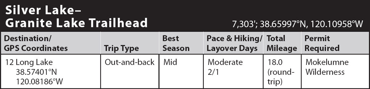
trip 12 Long Lake
Trip Data: |
38.57401°N, 120.08186°W; 18.0 miles; 2/1 days |
Topos: |
Caples Lake, Mokelumne Peak |
HIGHLIGHTS: A hike full of wonderful views leads to one of the area’s loveliest lakes, above which travelers will find campsites on granite benches that command spectacular views of the surrounding peaks.
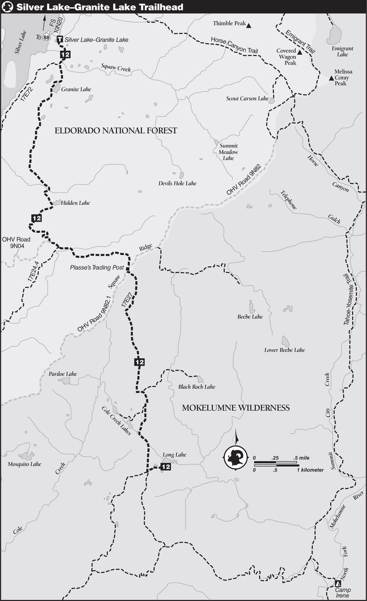
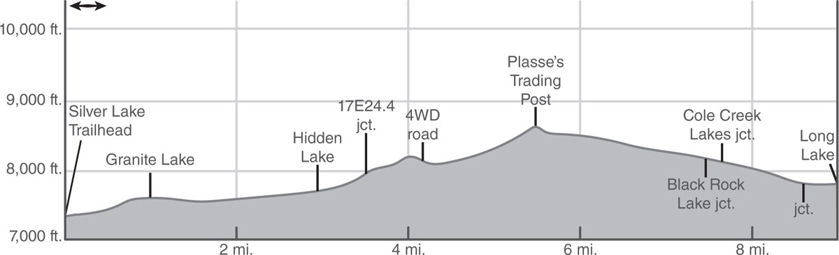
DAY 1 (Silver Lake–Granite Lake Trailhead to Long Lake, 9.0 miles): Locate the trailhead on the left-hand side of the road marked by a sign reading MANKALO TRAIL 17E72, GRANITE LAKE 1, PLASSES 3. Trail 17E23 begins on a gentle-to-moderate climb through a scattered forest of Jeffrey pines, lodgepole pines, and white firs. Proceed through granitic terrain dotted with aspens and manzanita past a seasonal pond/meadow and across a bridge over Squaw Creek. Beyond the bridge, reach a junction and turn left (south), following signed directions for Granite Lake. A steep climb leads up open terrain of granite slabs and shrubs to well-named Granite Lake, occupying a shallow basin of granite on a bench 550 feet above Silver Lake. Although the lake offers a few Spartan campsites sheltered by scattered conifers, the 1-mile distance from the trailhead ensures these sites are heavily used and therefore not recommended.

Granite Lake Photo by Mike White
Pass around the west shore of the lake and proceed through mixed forest past a stagnant pond and a flower-filled meadow. Continue straight ahead (south) at a T-junction, where the faint tread of Trail 17E72 heads right, providing an infrequently used connector to Plasse’s Resort. Beyond the junction, a mostly gentle ascent leads through the forest to the crossing of a seasonal stream, followed by a short but steeper climb to Hidden Lake. Conifers shade the near lakeshore, while the far shore is composed of meadows and clumps of willow backdropped nicely by granite cliffs. Good campsites will lure overnighters.
Climb out of Hidden Lake’s basin around pockets of willow-and-flower-carpeted meadows to a signed junction on top of a low ridge. Veer left (south) at the junction to pass by a verdant meadow and then a spring on a hemlock-shaded climb to a divide between the American River and Bear River drainages. Descending from this view-packed ridge, cross a drift fence and in less than 100 yards turn left (east-southeast) onto a four-wheel-drive road.
Traveling along the road, the grade is level past the Allen Ranch and then across the seasonal headwaters of Bear River. Now ascending, cross some perennial trickles and then veer to the right, leaving the road just before a small creek. Rejoin the road on the crest of Squaw Ridge, where a sign indicates the former site of Plasse’s Trading Post.
RAYMOND PLASSE
While traveling the Carson Emigrant Route, French immigrant Raymond Plasse fell in love with the area around Silver Lake. He established a trading post on Squaw Ridge in 1853 and ran it for many years before moving his family to the south end of the lake to raise cattle and operate a resort. No sign of the trading post exists today, but Plasse’s Resort, which includes a campground, boat rentals, restaurant and bar, and a general store, is in full operation each summer (plassesresort.com).
About 130 yards down from the ridge, leave the road by turning left (southeast) onto Trail 17E27 and soon entering Mokelumne Wilderness. In 1984, motorized vehicles were banned when the Mokelumne Wilderness was enlarged from 50,165 acres to the current 105,165 acres. The former roadbed began a process of rehabilitation. Just past the wilderness boundary the route passes above Horse Thief Spring, which usually flows all year. Sadly, due to intense cattle grazing, the springs are mere remnants of their former glory, but fill up here anyway, as this may be the last water before Cole Creek Lakes.
Continuing south, the nearly level trail passes some long meadows and then joins a broad volcanic ridge where views extend south all the way into the Carson-Iceberg Wilderness. As the trail descends the ridge, continue ahead (south) at a junction with the faint, old, unmapped trail to Cole Creek Lakes. At the next junction, with the trail heading left (northeast) to Black Rock Lake, you go right (south).
Now on granite terrain, cross another view-blessed ridge, which includes a closer look at Mokelumne Peak. Descending the rocky ridge, you meet a signed trail right (southwest) to Cole Creek Lakes. A level half-mile stroll through the forest is followed by a brief descent to the southernmost Cole Creek Lake. From the lake’s seasonal outlet, the trail makes a gentle descent southeast and then south for most of a mile before gradually ascending to the signed junction with the lateral to Long Lake.
Turn left (east-northeast) onto Trail 17E66 toward Long Lake, and in a short half mile, arrive at the south shore of many-bayed Long Lake (7,829'; 38.57401°N, 120.08186°W). People seemingly overuse the immediate lakeshore, but nice camping is available by skirting the south shore, crossing one of the tiny dams that enlarge this lake, and then heading east, away from the lake, onto open granite benches (e.g., 7,803'; 38.57523°N, 120.07810°W). Within several hundred yards of the lake are level, dry, cow- and mosquito-free campsites with fabulous views to the southeast over Wester Park to the headwaters of the Mokelumne River and the peaks around Ebbetts Pass.
DAY 2 (Long Lake to Silver Lake–Granite Lake Trailhead, 9.0 miles): Retrace your steps.