INFORMATION AND PERMITS: This trailhead is on Eldorado National Forest: 100 Forni Rd., Placerville, CA 95667; 530-622-5061, fs.usda.gov/eldorado. For visitor information, call 530-644-6048. Because this trip lies just outside of Mokelumne Wilderness, no permits are required at this time, but you must have a California Campfire Permit to have a campfire or use a stove.
Note: The Thunder Mountain Trailhead and the trail segment from there to the Horse Canyon Trail appear on the Mokelumne Wilderness map but not on the 1992 Caples Lake 7.5' topo.
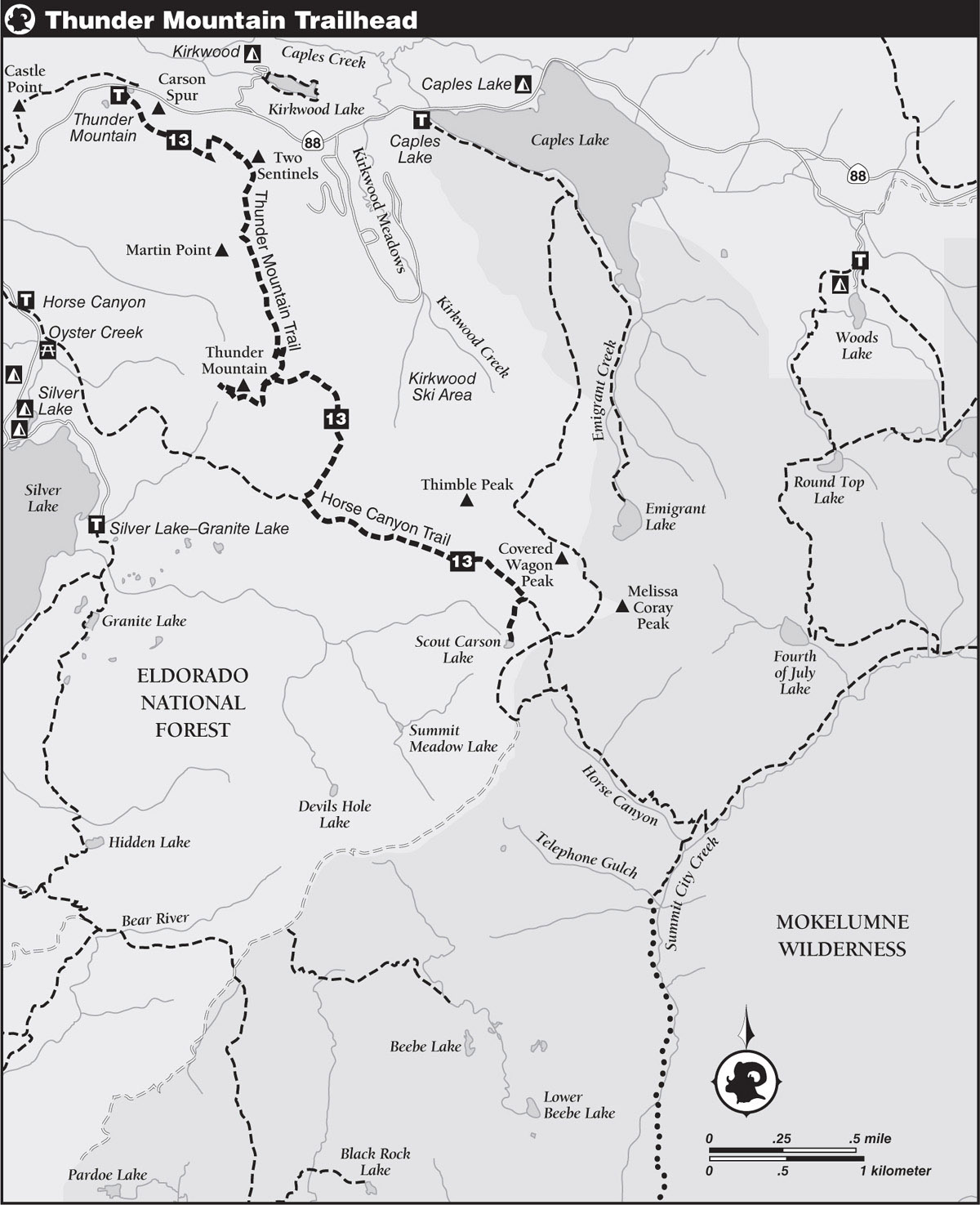
DRIVING DIRECTIONS: Follow CA 88 to the roadside trailhead for the Thunder Mountain Loop near Carson Spur, 3.25 miles east of Silver Lake and 1.75 miles west of the Kirkwood Meadows junction, on the south side of the highway.
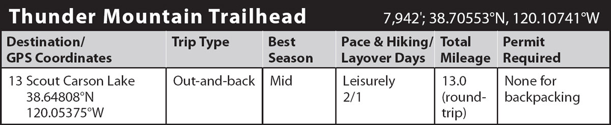
trip 13 Scout Carson Lake
Trip Data: |
38.64808°N, 120.05375°W; 13.0 miles; 2/1 days |
Topos: |
Caples Lake |
HIGHLIGHTS: A lovely, small, near-timberline lake is the goal of this trip, which passes through interesting geologic scenery along the way. An optional 1-mile round-trip detour to the 9,408-foot summit of Thunder Mountain offers an expansive 360-degree vista of the Carson Pass region. The route continues with fine views of the surrounding volcanic battlements on the way to Scout Carson Lake.
HEADS UP! A 1.7-mile section of the Horse Canyon Trail between the junction with the Thunder Mountain Trail and the spur to Scout Carson Lake is open to motorcycles. However, they seldom travel that far up the trail from Silver Lake.
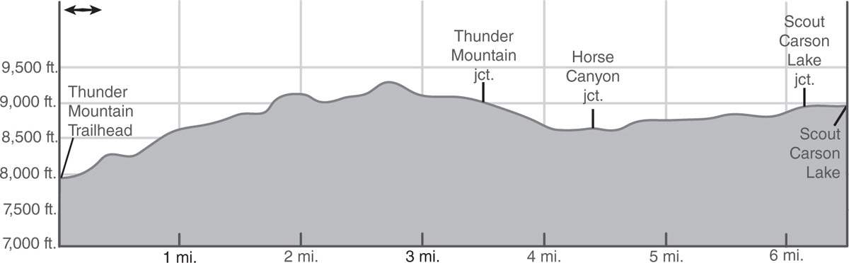
DAY 1 (Thunder Mountain Trailhead to Scout Carson Lake, 6.5 miles): Pass through a deteriorating cattle gate in a wire fence and proceed through a mixed forest of red firs, lodgepole pines, and western white pines, soon encountering a T-junction with a lightly used path that heads east to cross CA 88 and then travels west to Castle Point. Continue straight ahead (southeast) on the main trail on a moderate climb, breaking out of the trees on a climb across a sagebrush-and-wildflower-covered hillside below Carson Spur, where the rocky crags of Two Sentinels spring into view. Briefly gain the crest at a saddle before a climb across the west side of the ridge leads into thickening forest. Following a pair of switchbacks, traverse below the pinnacles of Two Sentinels to an open saddle, where the peaks of the Carson Pass area burst into view, along with Kirkwood Meadows and Caples Lake below.
Head south along the ridge toward Martin Point, with additional eastward views along the way. A couple of switchbacks lead to an upward traverse around the east side of Martin Point, revealing the impressive profile of Thunder Mountain’s north face, where the dark volcanic rock, punctuated with numerous clefts, gashes, pinnacles, and arêtes, creates a dramatic alpine scene. Continue the ascent along the ridgecrest toward Thunder Mountain. As you approach the northeast ridge of the peak, you make two more switchbacks and then follow a gentle traverse around the back of the ridge to the Thunder Mountain junction marked by a post, 3.5 miles from the trailhead.
THUNDER MOUNTAIN
Those who would like to bag a peak before continuing to Scout Carson Lake should turn right (southwest) at the junction and follow an ascending, westward traverse through scattered lodgepole pines, western white pines, mountain hemlocks, and whitebark pines. The trees diminish near the crest as the trail angles sharply to the east to follow the ridge to the summit. The top offers an incredible view in all directions, from the mountains of northern Yosemite in the south to the peaks of Desolation Wilderness in the north. Nearby landmarks include Silver and Caples Lakes and Round Top. After thoroughly enjoying the views, retrace your steps back to the junction.
Whether you’re skipping the side trip to the summit or returning from the top of Thunder Mountain, head east from the junction, traveling downhill across dry slopes through scattered to light timber to a junction with a faint path branching left (northeast) toward Kirkwood Meadows. Veer right and continue the descent into thickening forest until breaking out of the trees onto open, flower-filled slopes with excellent views of Silver Lake and Horse Canyon. Reach a junction at the bottom of the descent with the Horse Canyon Trail (17E21).
Turn left (southeast) at the junction and climb an open hillside, drop briefly to cross an unnamed, year-round creek, and then climb a sagebrush-dotted slope. Now at 8,800 feet, the trail follows a mile-long traverse across an open, flower-sprinkled bench on the south side of Thimble Peak. To the east of the peak are the tops of some of the ski lifts servicing Kirkwood Meadows in the next valley to the north. After passing an abandoned, overgrown path to Kirkwood Meadows, marked by an old post with a missing sign, ascend moderately through granite boulders to a signed junction in a sandy meadow with Trail 17E24.
Turn right (southwest) and stroll an easy half mile on a winding ascent through stands of mixed forest and pocket meadows to Scout Carson Lake (8,964'; 38.64808°N, 120.05375°W) on the edge of, but not in, Mokelumne Wilderness. Perched on a small bench, ringed by meadow, and surrounded by a forest of lodgepole pine, western white pine, and mountain hemlock, diminutive Scout Carson Lake is a sweet example of Sierra Nevada charm. Perhaps not so charming are the numerous mosquitoes buzzing through the air until late season. You can reduce if not eliminate this annoyance by camping away from the meadow-fringed lakeshore in favor of drier and rockier terrain to the west. The lake supports a small but fat population of brook trout, which gratefully eat the mosquitoes. Emigrant Peak to the east is a straightforward climb offering a superb view from the summit of much of Mokelumne Wilderness.
DAY 2 (Scout Carson Lake to Thunder Mountain Trailhead, 6.5 miles): Retrace your steps.

Stream in Horse Creek Canyon Photo by Mike White