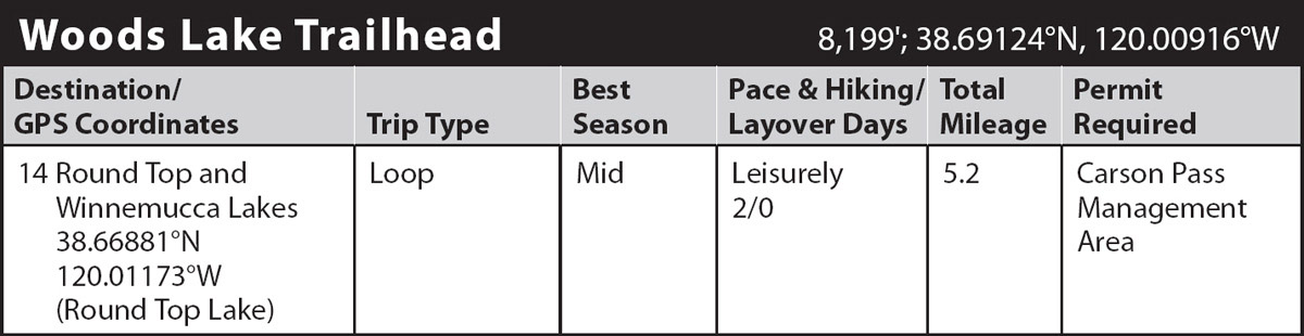
INFORMATION AND PERMITS: Camping in the Carson Pass Management Area (CPMA) is allowed only in designated sites at Winnemucca, Round Top, and Fourth of July Lakes. Permits for camping in these sites are only issued on a first-come, first-served basis at the Carson Pass Information Station, which is open seven days a week in the summer. The Carson Pass Information Station is located at the top of Carson Pass on CA 88, 6 miles east of the Kirkwood Mountain Resort. See the Eldorado National Forest website for details. Campfires are prohibited within the CPMA at all times. There’s a fee to park at the trailhead, which is in the Eldorado National Forest: 100 Forni Rd., Placerville, CA 95667; 530-622-5061, fs.usda.gov/eldorado. For visitor information, call 530-644-6048.
DRIVING DIRECTIONS: Turn off CA 88 at the signed Woods Lake access road, 1.7 miles west of Carson Pass. Follow the paved road 0.8 mile to a junction and turn right, proceeding another 0.1 mile to the Woods Lake Trailhead, where motorists must cough up a nominal fee for parking. Toilets and water are available.
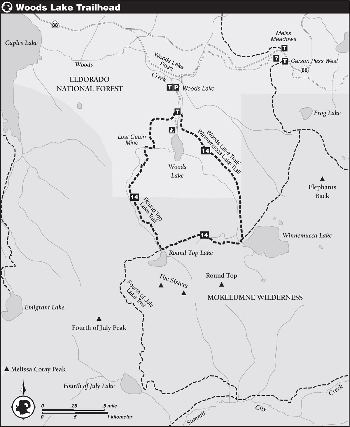
trip 14 Round Top and Winnemucca Lakes
Trip Data: |
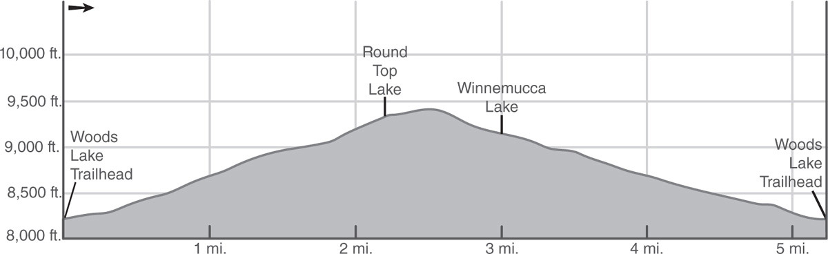
38.66881°N, 120.01173°W (Round Top Lake); 5.2 miles; 2/0 days |
Topos: |
Caples Lake, Carson Pass |
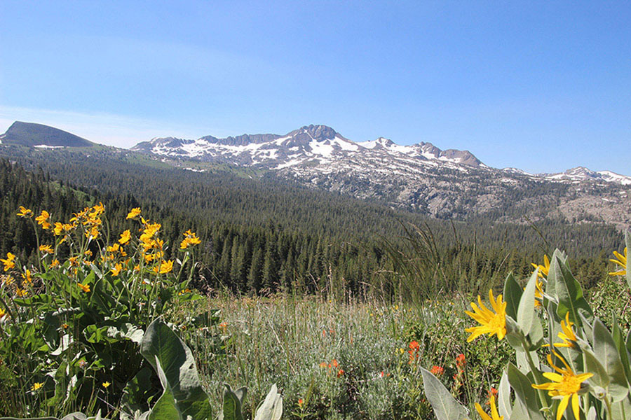
HIGHLIGHTS: Two picturesque lakes backdropped by craggy volcanic summits provide the main highlights on this very popular loop trip through Mokelumne Wilderness. Midsummer visitors will have the added bonus of a number of wildflower-laden meadows. Ambitious peak baggers can make a side trip to the summit of Round Top.
DAY 1 (Woods Lake Trailhead to Round Top Lake, 2.2 miles): From the trailhead parking lot, walk a short distance on the access road toward Woods Lake Campground and find the official start of the Round Top Lake Trail just past a bridge (don’t cross the bridge). Stroll along on a dirt trail through mixed forest, soon rising above Woods Lake Campground, where singletrack trail merges with an old roadbed. Follow the road on a stiff, winding climb to the signed Lost Cabin Mine Trailhead, a half mile from the parking lot.
Now on singletrack again, make a moderate climb with filtered views of Round Top and Woods Lake through the trees. Hop across boulder- and willow-lined Woods Creek and follow a switchbacking climb above the old structures of the Lost Cabin Mine, which produced gold, silver, copper, and lead before shutting down in the early 1960s. The mine is still considered private property, so resist the urge to trespass. Continue the steady ascent, roughly following the west branch of Woods Creek. The grade eventually eases near the signed Mokelumne Wilderness boundary as the volcanic summits of Round Top and the Sisters come into view. The canyon broadens farther upstream amid more open vegetation of willow, heather, and wildflowers, which allows even better views. Reach a junction with the Fourth of July Lake Trail near the north shore of Round Top Lake (9,350'; 38.66881°N, 120.01173°W), 2.2 miles from the parking lot.
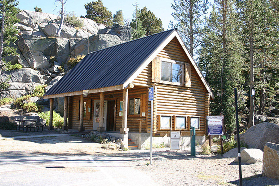
Carson Pass Information Station Photo by Mike White
Round Top is a stunningly scenic lake rimmed with stands of whitebark pines and backdropped by the broodingly dark slopes of Round Top and the Sisters. To promote revegetation of the shoreline, overnighters are limited to six designated, mostly hard-to-find campsites on the northwest side of the lake, available by reservation only.
CLIMBING ROUND TOP
Competent peak baggers can climb nearby Round Top (10,381'). From Round Top Lake, leave the trail and travel southeast on a well-defined use trail up the prominent gully located between the east Sister and Round Top. Initially, the route heads toward the saddle between the two peaks, but higher up the slope, it veers left of the saddle to a prominent notch in Round Top’s northwest ridge. Follow the backside of the ridge to a false summit that should satisfy most nonclimbers as their ultimate destination. The true summit is only a few feet higher and is separated from the false summit by a steep cleft of loose rock that should be negotiated only by skilled mountaineers, as the exposure is quite significant. Both summits offer spectacularly expansive views of the northern Sierra.
OPTIONAL HIKES
Emigrant Lake: From the junction near the north shore of Round Top Lake, turn onto the Fourth of July Lake Trail and follow an arcing traverse around the west shoulder of the Sisters to the crest of a divide. From there, experienced cross-country travelers can access Emigrant Lake by traversing west to a notch directly southeast of Point 9,020, as shown on the Caples Lake quadrangle, and then dropping steeply to the lake’s outlet.
Fourth of July Lake: From the crest mentioned above, continue on the Fourth of July Lake Trail on a switchbacking descent that loses 1,000 feet of elevation on the way to Fourth of July Lake. Colorful wildflowers should cheer midsummer hikers along the descent. Fourth of July Lake is quite scenic, cradled in a rocky amphitheater between Fourth of July Peak and Peaks 9,795 and 9,607. A mixture of open meadows, pockets of willow, and stands of white fir and western white pine ring the shoreline. Six designated campsites are scattered around the lake, one near the outlet, two on a forested rise above the northeast shore, and three near the edge of the meadow on the northwest side.
DAY 2 (Round Top Lake to Woods Lake Trailhead, 3 miles): Return to the junction with the trail (on your right) that you took to get up to Round Top Lake. Here, go ahead (east toward Winnemucca Lake) on a gradually rising ascent over a granite ridge peppered with wind-battered whitebark pines and ground-hugging shrubs. Once across the crest, follow the trail downslope through open terrain and across the outlet of Winnemucca Lake to its west shore and a junction.
Windswept Winnemucca Lake sits majestically at the base of Round Top Peak’s north face, with the rounded hump of Elephants Back a mile to the northeast. The mostly open terrain is broken by scattered clumps of whitebark pine that shelter three designated campsites above the north shore.
At a junction at Winnemucca’s west end, turn left (north) toward Woods Lake and follow the trail along the course of the east branch of Woods Creek through sagebrush, willows, and a fine assortment of wildflowers in season. Exit Mokelumne Wilderness about a half mile from the lake and continue the steady descent into mixed forest. Nearing the trailhead, pass a lateral on the left to Woods Lake, stroll across a wood bridge, walk across the paved access road, and walk a short distance to the parking area.
Round Top Photo by Mike White