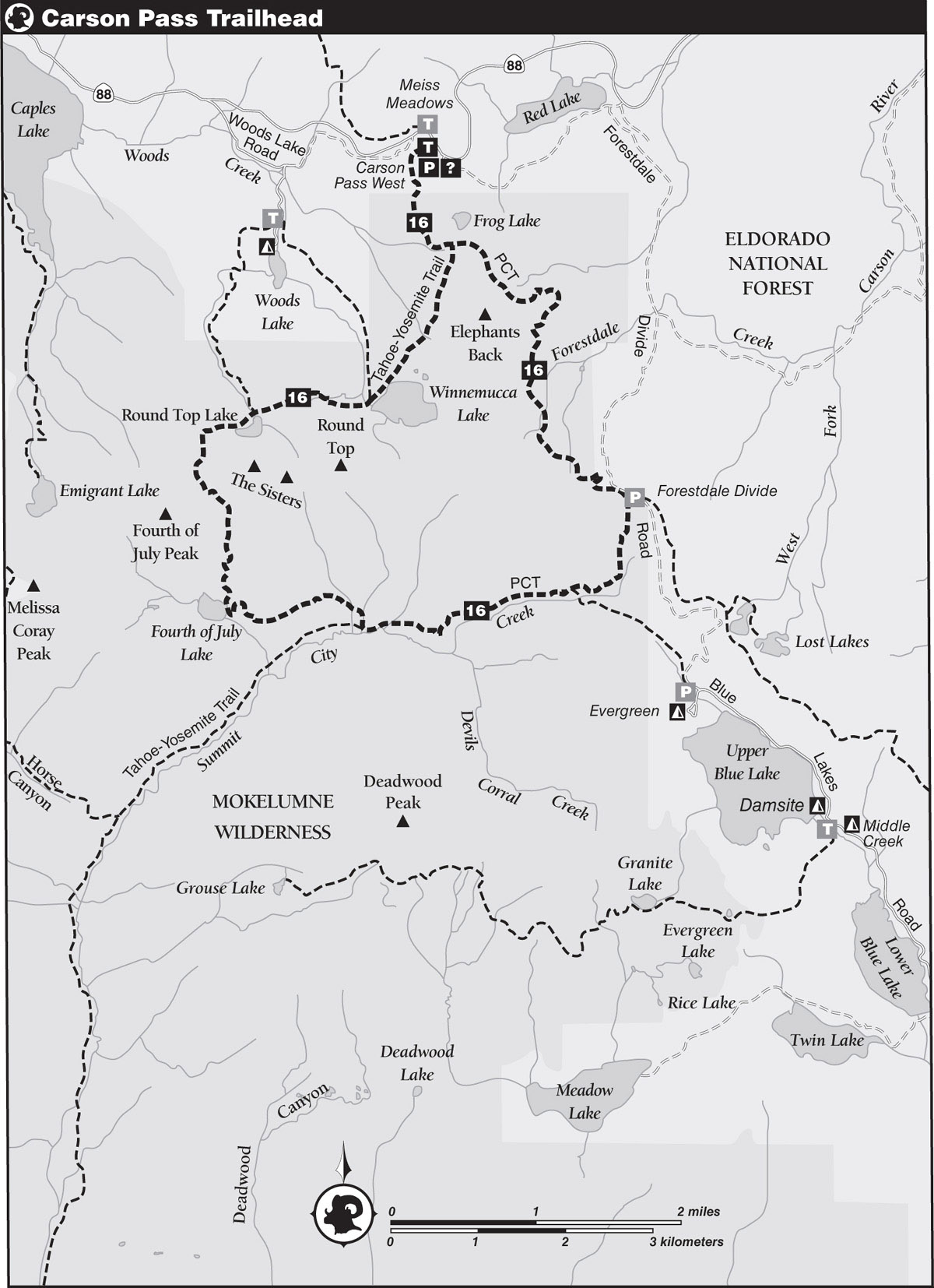
INFORMATION AND PERMITS: Camping in the Carson Pass Management Area (CPMA) is allowed only in the designated sites at Winnemucca, Round Top, and Fourth of July Lakes. Permits for camping in these sites are only issued on a first-come, first-served basis at the Carson Pass Information Station, which is open seven days a week in the summer. The Carson Pass Information Station is located at the top of Carson Pass on CA 88, 6 miles east of the Kirkwood Mountain Resort. See the Eldorado National Forest website for more information. Campfires are prohibited within the CPMA at all times. There’s a fee to park at the trailhead, which is in the Eldorado National Forest: 100 Forni Road, Placerville, CA 95667; 530-622-5061; fs.usda.gov/eldorado. For visitor information, call 530-644-6048.
DRIVING DIRECTIONS: The trailhead is right at Carson Pass on CA 88, on the highway’s south side, where you’ll also find the Carson Pass Information Station. The trailhead is on the station’s west side. As trails emanating from Carson Pass are extremely popular, the main parking lot usually fills up by midmorning. Secondary parking may be available a very short distance eastbound from the pass on the shoulders of an old road (you’ll still have to pay a fee to park there).
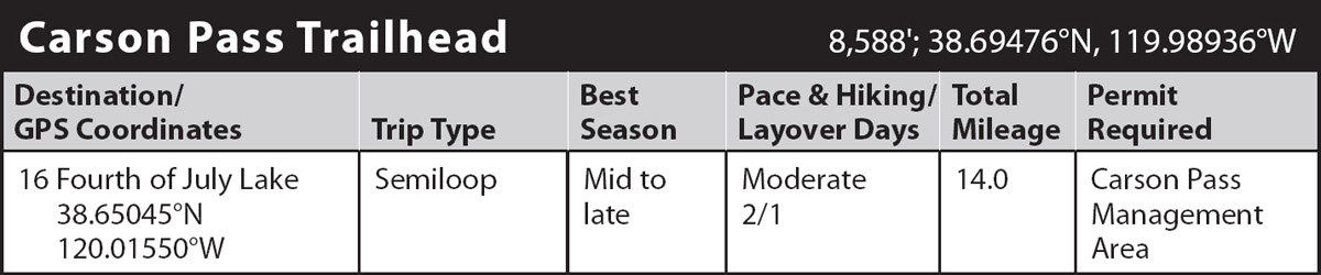
trip 16 Fourth of July Lake
Trip Data: |
38.65045°N, 120.01550°W; 14.0 miles; 2/1 days |
Topos: |
Caples Lake, Carson Pass |
HIGHLIGHTS: Backpackers who don’t mind regaining lost elevation will appreciate this semiloop trip through the northeast section of Mokelumne Wilderness, which includes several ponds and lakes, wildflower-covered slopes, sweeping vistas, and a deep canyon.
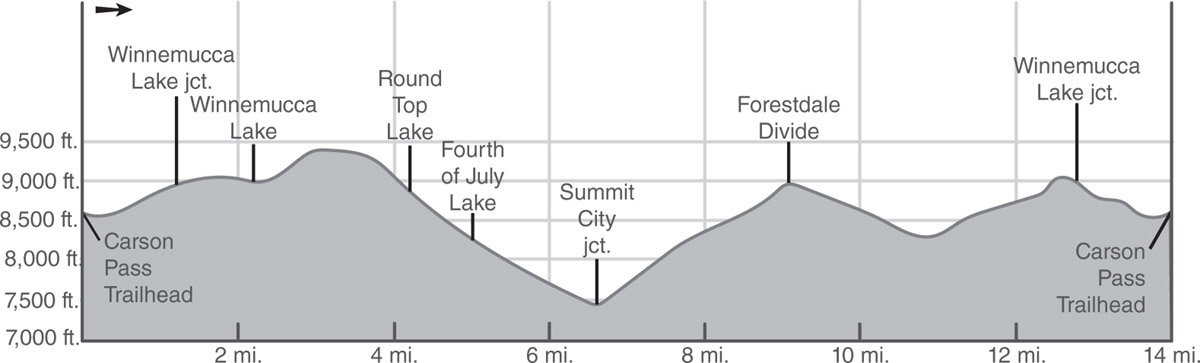
DAY 1 (Carson Pass Trailhead to Fourth of July Lake, 5.5 miles): Find this section of the Pacific Crest Trail (PCT)/Tahoe-Yosemite Trail (TYT) on the west side of the Carson Pass Information Station, and head south on the wide, well-traveled path through a mixed forest of lodgepole pines, mountain hemlocks, and western white pines. The gradually descending trail leads past a small pond surrounded by willows before making a gentle-to-moderate ascent as the trail crosses the Mokelumne Wilderness and CPMA boundary and switchbacks toward the Sierra Crest. The forest thins on the approach to a ridge, allowing glimpses of the volcanic summits of Round Top and the Sisters. On a plateau, reach a junction with a short trail left (northeast) to Frog Lake (no camping), which fills a shallow depression in an open bowl dotted with widely scattered pines. The 10-minute walk to the far end of the lake is a worthy diversion for views straight down the edge of a cliff to Red Lake and out toward Hope Valley and peaks of the southern Carson Range. Just as impressive is the view across the lake of the dark ramparts of Round Top. Early-season visitors will be treated to a fine display of wildflowers as well.
JOHN C. FRÉMONT
With Kit Carson as his scout, John C. Frémont made the first winter crossing of the Sierra somewhere on this plateau in February of 1844. From an encampment in Faith Valley a few miles to the east, Frémont, along with his chief cartographer, Charles Preuss, climbed Red Lake Peak, just north of Carson Pass. From the summit, they were the first Europeans to see the great mountain lake we now know as Tahoe. The climb of Red Lake Peak was the first recorded ascent by Europeans of an identifiable Sierra mountain.
From the unmarked junction to Frog Lake, go ahead (south) a short way to a junction and turn right (south-southwest), leaving the PCT behind to follow the TYT on a descent across open slopes on the west side of Elephants Back. Continue the mile-long descent toward Winnemucca Lake through shrub-covered slopes dotted with small groves of whitebark and lodgepole pines, enjoying excellent views of hulking Round Top along the way. Seasonally, a meadow near Winnemucca Lake offers an unbelievable wildflower display. Cruise picturesque Winnemucca’s west shore beneath Round Top to a junction, marked by a post, with a trail to Woods Lake.
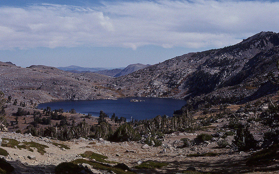
Winnemucca Lake Photo by Mike White
Hikers descend through Summit City Canyon. Photo by Mike White
WHITEBARK PINES
Stands of high-altitude-loving whitebark pines provide nesting places for hundreds of Clark’s nutcrackers, which swoop back and forth over the heads of hikers. These birds eat lots of whitebark pine nuts. The Clark’s nutcracker’s fondness for these nuts is probably one of the main reasons whitebarks expand their territory. These large, noisy, crowlike, gray-and-white birds are messy eaters, dropping seeds to the ground while picking the cones apart, thus helping to propagate new pines.
Go ahead (south-southwest) from the junction, ford the lake’s outlet, and begin a moderate climb up a gully covered with pockets of willow, heather, and grasses to the crossing of a stream. Continue the ascent to a saddle and then descend shortly to a junction near the north shore of Round Top Lake, with another trail to Woods Lake.
Go left (southwest) from the junction and follow an arcing traverse around the west shoulder of the Sisters to the crest of a divide. On the far side of Round Top Lake, the steep cliff is a mélange of grays, greens, and browns, and the surrounding talus slopes vary in color according to which bedrock yielded up which talus blocks. All the rock outcroppings in this region are dark colored. Volcanic rocks are normally dark, but even the granite here is much darker than the shining granites found in Desolation Valley. Along this stretch of trail, views are excellent (scanning from east to north to west) of Markleeville Peak, Hawkins Peak, the Crystal Range, the slopes above Caples Creek, and Caples Lake.
Soon the TYT descends to a saddle, leaving the basin of the American River and entering the Mokelumne River drainage. From the crest, avoid a faint use trail to Fourth of July Peak and follow the main trail as it descends almost 1,000 feet on gradual-to-moderate switchbacks through a handsome bowl toward Fourth of July Lake. Colorful wildflowers should cheer midsummer hikers along the descent.
At a junction abreast of Fourth of July Lake, turn right (west) to the lake (8,201'; 38.65045°N, 120.01550°W), which is quite scenic, cradled in a rocky amphitheater between Fourth of July Peak and Peaks 9,795 and 9,607. A mixture of open meadows, pockets of willow, and stands of white fir and western white pine ring the shoreline. Your campsite is one of the six designated sites at this pretty lake.
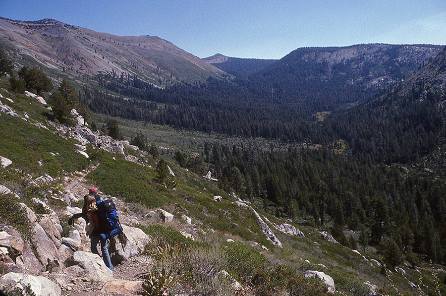
DAY 2 (Fourth of July Lake to Carson Pass Trailhead, 8.5 miles): From Fourth of July Lake, the trail heads south to follow a switchbacking course through mixed forest out of the Carson Pass Management Area before veering northeast and emerging onto open, brush-covered slopes allowing expansive views of Summit City Canyon. A long, descending traverse across these slopes leads down toward the floor of the canyon and into lodgepole pine forest on the way to a junction with the trail on the canyon’s floor. Here, the Tahoe-Yosemite Trail turns right (west, then southwest), but your trip turns left (east) to head through the trees, passing a campsite and soon reaching a second junction, marked by a post.
Take the left fork, following signed directions generally east to the PCT on a 3-mile climb, initially through a lodgepole pine forest with a lush understory of plants and flowers. A steady ascent on the sometimes-rocky trail leads away from the floor of Summit City Canyon, where the groundcover soon disappears beneath a dense forest of red firs and western white pines. After a few long switchbacks, the trail emerges from the forest and onto brush-covered slopes with fine views of the canyon rimmed by impressive-looking mountains to the south. The shrubs are quite thick, threatening to overgrow the trail in spots and at times reaching over-the-head heights. Well-watered slopes farther upslope harbor ferns, willows, alders, young aspens, and an assortment of wildflowers, including tall alpine knotweeds. Sagebrush heralds the final approach to Forestdale Divide and a junction with the PCT.
Turn left (west) onto the PCT at the junction and make a short climb over the crest of Forestdale Divide, exiting the Mokelumne Wilderness and beginning a winding descent to a verdant bench harboring a group of subalpine ponds near the head of Forestdale Creek’s canyon. Although the ponds are never more than knee deep, the sweeping views extending from Elephants Back to Hope Valley create a picturesque setting quite suitable for a lingering break.
Continue the descent away from the bench to cross a branch of Forestdale Creek. Past the creek, a stiff, winding climb begins across flower-covered slopes on the east side of Elephants Back, where amateur botanists will see a diverse assortment of wildflower species during the height of the season. The 900-foot ascent leads to the crest of Elephants Back’s north ridge and back into Mokelumne Wilderness and Carson Pass Management Area, topping out south of Frog Lake. A short descent leads to the junction with the TYT on its way from Carson Pass (right) to Winnemucca Lake (left). You close the loop here, turn right (ahead, first west and then north), and retrace your steps along the PCT/TYT to the Carson Pass Trailhead.