INFORMATION AND PERMITS: As with other Mokelumne Wilderness destinations off CA 88, this trailhead is in the Eldorado National Forest: 100 Forni Rd., Placerville, CA 95667; 530-622-5061, fs.usda.gov/eldorado. For visitor information, call 530-644-6048.
You must have a permit to camp overnight in Mokelumne Wilderness; download your permit at fs.usda.gov/Internet/FSE_DOCUMENTS/fseprd754168.pdf.
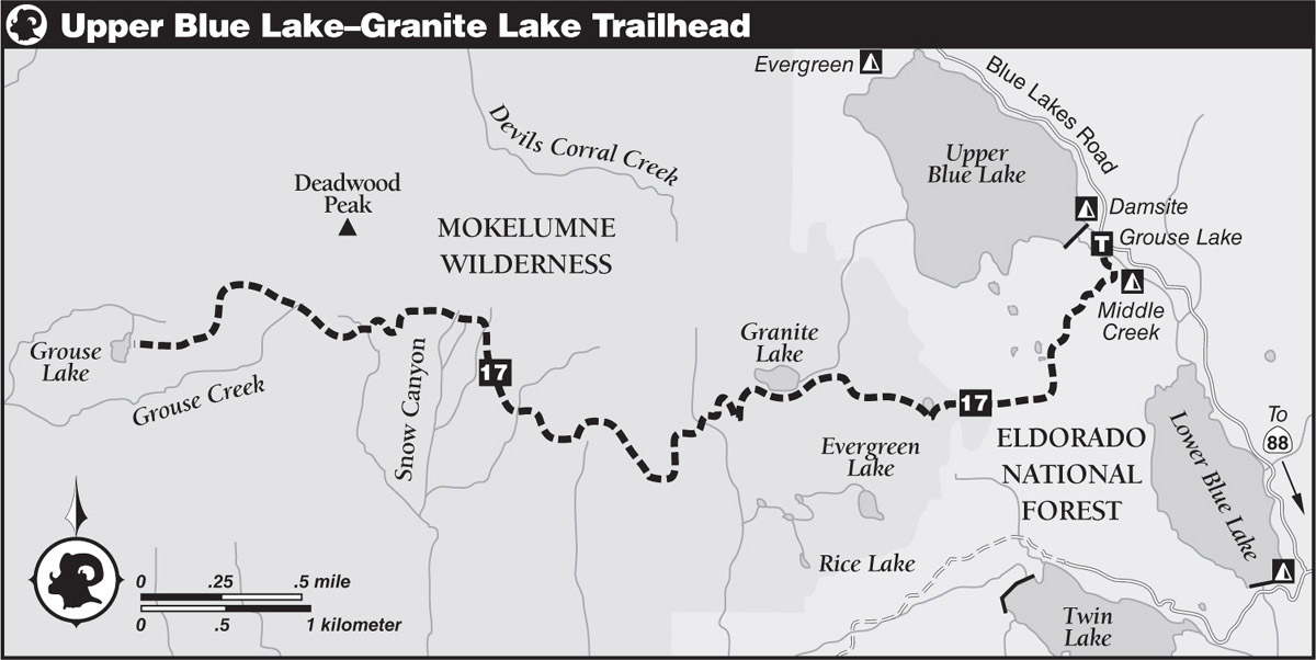
DRIVING DIRECTIONS: Leave CA 88 at 6.3 miles east of Carson Pass and head south on Blue Lakes Road through Hope Valley and over Forestdale Divide to a junction with the road to Lower Blue Lake, 10.3 miles from the highway. Continue straight ahead for another mile and turn right at the Mokelumne Hydro Project. Proceed past Middle Blue Lake to a small parking area on the left, just below the spillway of Upper Blue Lake, 13 miles from CA 88.
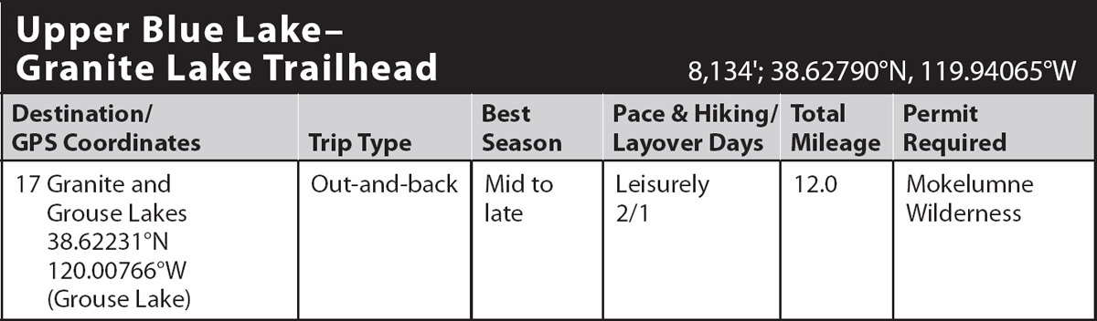
trip 17 Granite and Grouse Lakes
Trip Data: |
38.62231°N, 120.00766°W (Grouse Lake); 12.0 miles; 2/1 days |
Topos: |
Carson Pass, Pacific Valley, Mokelumne Peak |
HIGHLIGHTS: Nestled into a little-traveled corner of Mokelumne Wilderness, Grouse Lake sits high above Summit City Canyon. Requiring only modest effort, this hike offers both the spectacular scenery of sweeping vistas and the intriguing beauty of geologic diversity.
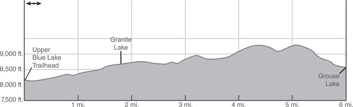
DAY 1 (Upper Blue Lake–Granite Lake Trailhead to Grouse Lake, 6.0 miles): Grouse Lake Trail begins just south of Middle Creek Campground. From the parking area, cross the seasonal channel of the spillway overflow on a steel pedestrian bridge and immediately turn left (south) into lodgepole pine forest and head briefly downstream alongside the overflow channel until the trail veers away and reaches a log crossing of the perennial outflow from Upper Blue Lake. The nearly level trail leads past an unsigned lateral to the campground (ignore it) before your trail swings west on a gentle ascent with tree-shrouded views of the surrounding peaks, including Round Top. The grade eases momentarily at the signed crossing of the Mokelumne Wilderness boundary. Continuing west, skirt a small pond to the crossing of the outlet, climb steeply northwest to a shoulder, and go west through small meadows and past a tarn. Ascend a small ridge and then descend to swing west-southwest next to the flower-lined, seasonal outlet from Granite Lake. Soon the lake springs into view, cradled in a small basin surrounded by weathered granite outcrops.
Skirt the south shore of the lake past campsite laterals and veer left over a low ridge. Beyond the lake, you leave most day hikers behind, as the trail winds west for most of a mile through the weathered granite landscape, passing pockets of mixed forest and a small, flower-lined creek. Farther on, a very steep climb on deteriorating tread leads to a stunning vista: Clockwise from the east is the Carson Range (mostly in Nevada); dark, volcanic Raymond Peak; metamorphic Highland, Stanislaus, and Leavitt Peaks; and the polished, light granite of the deep cleft of North Fork Mokelumne River Canyon.
Continue through open terrain past an old gravesite, followed by a gradual descent across a verdant, flower-dotted meadow. Beyond the meadow, a lengthy ascent leads across several gullies to a sloping bench bisected by several spring-fed rills.
GEOLOGY LESSON
On the sloping bench, notice how light granite overlies dark volcanic bedrock. A slope change typically occurs at such a contact zone, as the overlying volcanic rock is softer and more easily eroded than granite. The numerous spring-fed rills indicate that the volcanic rock above holds more water than the granite below.
Descend west to a small creek, remaining on the north side, and climb through willows a short distance past the source of the creek. Continue climbing as the trail fades on an open slope. A ducked route levels off and contours northwest for 0.25 mile, until multiple paths descend a flower-filled gully dotted with boulders, where Grouse Lake appears several hundred feet below. Eventually the paths merge into a single trail that continues the descent into thickening forest to the shore of the secluded lake (8,563'; 38.62231°N, 120.00766°W). On a hot day, Grouse Lake provides a wonderful wilderness swimming pool. Nearby viewpoints offer glimpses of Summit City Canyon below to the west. Golden eagles, which traditionally nest in the canyon, may occasionally be seen riding thermals to dizzying heights above.
DAY 2 (Grouse Lake to Upper Blue Lake–Granite Lake Trailhead, 6.0 miles): Retrace your steps to the trailhead.