
INFORMATION AND PERMITS: Wilderness permits are required here, but there are no quotas, so you can get one at the trailhead. This High Trailhead trip is in the Humboldt-Toiyabe National Forest: Carson Ranger District, 1536 S. Carson St., Carson City, NV 89701; 775-331-6444, fs.usda.gov/htnf.
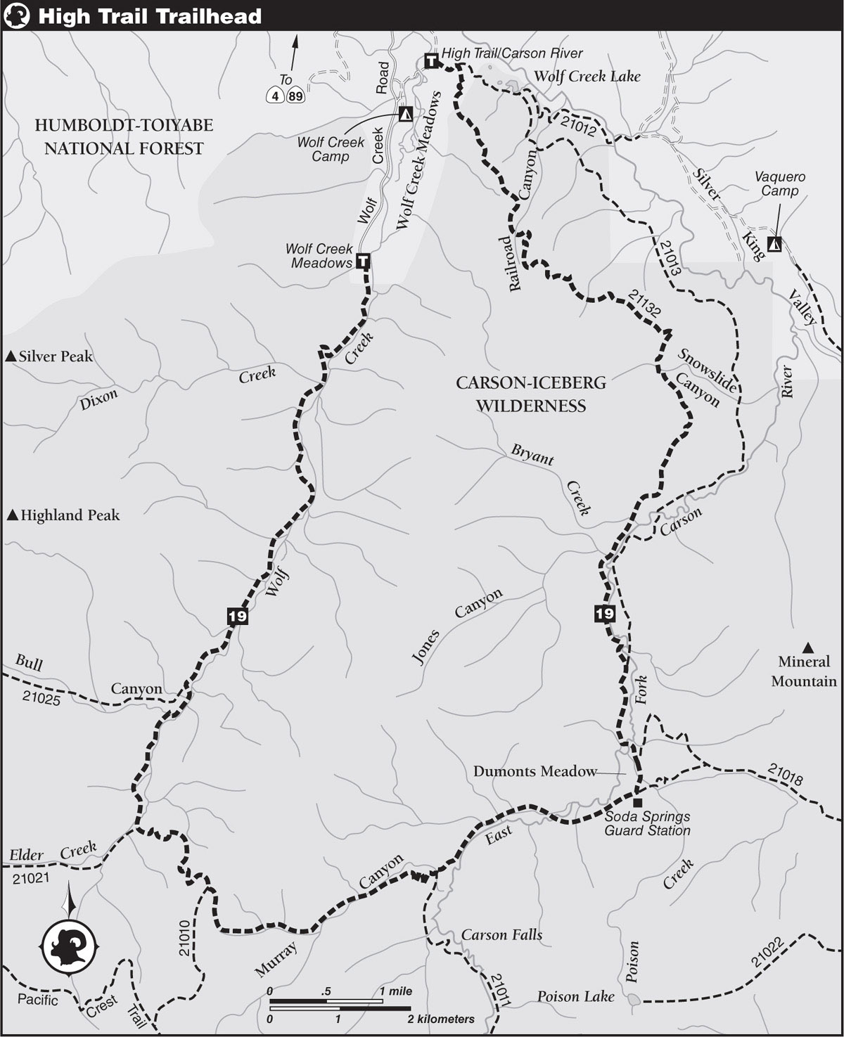
DRIVING DIRECTIONS: From the junction of CA 4 and CA 89 south of Markleeville and east of Ebbetts Pass, drive about 2.5 miles south on CA 4 and then turn southeast on the signed Wolf Creek Road. Proceed 3.3 miles to a fork, turn left following signed directions for the High Trail and Carson River Trailhead, and descend northeast around the north end of Wolf Creek Meadows. Past the meadows, the road climbs through the trees and, at 0.6 mile from Wolf Creek Road, reaches a spur road heading southeast a short distance to the trailhead.
SHUTTLE DIRECTIONS: Driving to the endpoint at the Wolf Creek Meadows Trailhead begins the same as driving to the High Trailhead: From the junction of CA 89 and CA 4 south of Markleeville and east of Ebbetts Pass, drive about 2.5 miles south on CA 4 and then turn southeast onto Wolf Creek Road. Proceed 3.3 miles to a fork. Avoiding the left fork (which leads to the High Trailhead), continue ahead (south) on Wolf Creek Road 1.5 miles to where the road bends sharply left. The signed Wolf Creek Meadows Trail is on the right immediately after the bend.
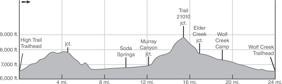
Note: This hike can be done as either a two-day or three-day trip. In the past it was described as two 12-mile days, but given the strenuous character of the climb up Murray Canyon it might suit many hikers better as a three-day hike, hiking 10 miles to Soda Springs the first day, then 9 tough miles to camp along Wolf Creek, followed by a shorter 5-mile-out day, which would be especially appreciated if you only brought one car and would need to do a 2-mile walk back to your car from the Wolf Creek Trailhead.
trip 19 Wolf Creek Meadows
Trip Data: |
38.57595°N, 119.69774°W (Wolf Creek Trailhead); 24.0 miles; 3/0 days |
Topos: |
Wolf Creek, Disaster Peak |
HIGHLIGHTS: This lightly traveled trail provides access to true wilderness; don’t be surprised if you see more bears than people. Enjoy excellent views of deep valleys from the High Trail ridge and stunning vistas of surrounding peaks from the top of Murray Canyon.
HEADS UP! Much of this route is not shown, or is shown incorrectly, on maps and in previous guidebooks, as the trail network has changed significantly over the years. These trails are lightly used and maintenance has been spotty, so they can be indistinct and a real challenge to follow. Bring a friend, a compass, and a good sense of direction to make good decisions.
DAY 1 (High Trailhead to Soda Springs, 10.0 miles): At the edge of a volcanic slope covered with sagebrush, bitterbrush, and mule ears, the High Trail climbs upward into an open forest of Jeffrey pine and white fir to the Carson-Iceberg Wilderness boundary and shortly after a junction of the High Trail and the faint East Fork Carson River Trail.
Turn right (south) at the junction onto the High Trail, experiencing brief views of Wolf Creek Meadows. Leaving the views of the meadows behind, you climb steeply through a shady forest. At 1.2 miles you reach a large split boulder and a large mountain mahogany as the trail parallels the ridge up to a level crest and then climbs steeply to a small, grassy flat at about 2 miles from the trailhead. Past the flat, the trail makes an uphill traverse across a grassy, gentle slope containing a curious combination of water-loving aspens and drought-resistant junipers. Jeffrey pines, white firs, willows, sagebrush, and mule ears complete the cast of unlikely plant combos.
Climb shady slopes for about 0.75 mile beyond the meadow until the steep grade of the trail eases across a level area. Here, you get your first views into the expansive Silver Valley, as well as a brief view of the Vaquero Camp cabins to the east.
You now begin a lengthy jaunt along the volcanic ridgeline with frequent views of Silver Valley. The jaunt begins with a short journey through a thick forest, then goes back and forth between open views north into Bagley Valley and distant Freel Peak (beyond whose summit lies Lake Tahoe), and to the east of Silver Valley.
AUTOBRECCIATED LAVA FLOW
Along this short, open traverse is a good exposure of a blocky volcanic rock common to this “land of fire and ice” and known as an autobrecciated (self-broken) lava flow. Geologists speculate that from the middle Miocene epoch through the late Pliocene epoch, thick andesitic lava flows poured from summits that were perhaps similar to the Oregon Cascades of our time. These lava flows covered an area of the Sierra Nevada from Sonora Pass north to Lassen Park and from east of the present Sierra Crest westward to the Central Valley. Flowing along their downward paths, the thick lava flows cooled and became less and less able to move, particularly on the rapidly cooling edges that eventually solidified. Pressure from the still-flowing internal areas fractured the edges, creating the broken-up texture seen today.
“Autobrecciated lava flow” is a mouthful. The Hawaiians, who live intimately with volcanoes, call such flows aa, pronounced “Ah! Ah!” and equivalent to “Ow! Ow!,” which is what you might say if you walked on aa in bare feet. We’ll use aa instead of “autobrecciated lava flow.”
With most of your climbing done, you are now traversing the steep volcanic slope, and in places the trail is narrow, eroded, and requires concentration on your footing to avoid a slip. At about 4.5 miles you reach a junction. The main trail goes straight and a trail loop leads in about 50 yards to a view at the top of a knoll. Here you get the best views of the day—a good place for lunch. The wide expansive view of the valley below makes you feel alone in the world.
Back on the trail, pass through a forest of Jeffrey pine and firs, then descend steeply south through the open slope above Snowslide Canyon. Volcanic rocks give way to granitic ones as you leave the brushy canyon on a descent through forest. Near the bottom of the descent you can look up at interesting granite rock pilings.
The descent briefly ends with a short uphill, before the first views of East Fork Carson River Canyon and the river itself foretell a series of short, steep switchbacks through the rocky granitic terrain. Then the trail diagonals less steeply across the slope southwest to a junction with the East Fork Carson River Trail. Your trail goes straight and parallels the river, soon fording a creek.
Soda Springs Photo by Tim Hauserman
Older maps and previous guidebooks describe crossing the river here, but there is no longer a crossing. Now you follow a lovely trail that parallels the river without crossing for the next 2 miles. It is mostly level, through an open forest of Jeffrey pines, and gives frequent glimpses of the river. While there are no obvious campsites, you could certainly camp here.
FISH IN THE EAST FORK CARSON RIVER
A likely catch for anglers is the mountain whitefish, which resembles a cross between a trout and a sucker. A small mouth on the lower part of its head is the sucker characteristic, but the presence of an adipose fin on the lower back identifies it as a close relative of trout and salmon. As with those two fish, the whitefish is good to eat. The river also is home to the Tahoe sucker, whose protractile mouth on the bottom of its head is ideally suited for scavenging the river bottom. Although bony, the Tahoe sucker is quite tasty.
Near the end of this easy romp along the river, you cross a grassy meadow and then reach a ford of the river. While by late summer the water is fairly low, you still have to walk about 20 feet across the water. Bring your water sandals because there is a more difficult ford ahead. Across the river, it can be a challenge to find the trail, but it wanders through more grassy meadow to the south, and then into the forest again, where you meet the Poison Flat Trail to the left.
Straight ahead you shortly cross Poison Creek, which is not poisonous. Just after the creek you note a fenced-in meadow to your right and continue ahead a short distance to the Soda Springs Administrative Site.
SODA SPRINGS ADMINISTRATIVE SITE
The buildings and corral complex that compose the Soda Springs Administrative Site were constructed as a guard station during World War II by a group of conscientious objectors. It was staffed by U.S. Forest Service personnel until it became part of the Carson-Iceberg Wilderness, and it was placed on the National Register of Historic Places in 1994. After bear break-ins an electric bear fence was constructed around the buildings.
Backpacker campsites are available by Poison Creek (6,776'; 38.50960N°, 119.65245°W), or near a small creek 0.3 mile along the trail west of the guard station, or farther down the trail at a ford of the East Fork Carson River. Camping is prohibited in the administrative site’s immediate vicinity; read and follow all posted regulations.
DAY 2 (Soda Springs to Wolf Creek, 9.0 miles): From the administrative site, the trail continues west through an open forest just a short distance upslope of the meandering creek, which is often obscured by brush. In about a mile the trail bends to the north and crosses a meadow and heads to a challenging ford of the river. Here, just before the crossing, lies a campsite in the grass.
This ford is shorter than the first one, but deeper. Across the river, the trail may be challenging to find, but your goal is to follow the river upstream. Once you locate the trail, it winds along a level, sandy, open forest with a gentle ascent. Keep your eyes peeled because overgrowth and lack of trail maintenance will most likely cause you trouble with keeping on the trail. You cross several small streams before reaching a junction just after crossing Murray Canyon Creek. Here the Murray Canyon Trail and Golden Canyon Trail meet, and several campsites can be found near here if you decide this is where you want to camp to do the trail in two days.
At the signed trail junction, take the right fork generally westward, and climb, steeply at times, up more than a dozen switchback legs that lead high up a brushy, open-forested slope and into Murray Canyon. Nice views of Falls Meadows open up quickly.
MURRAY CANYON GLACIER
Like virtually every tributary of East Fork Carson River upstream of Soda Springs, Murray Canyon held a glacier at the same time as a glacier occupied the East Fork Carson River’s canyon. However, being much smaller, the Murray Canyon glacier was unable to keep pace with the tremendous excavating power of East Fork Carson River’s glacier, which was estimated to be as thick as 800 feet in this area. As a result, the glacier cut deeper, leaving Murray Canyon as a hanging valley—the same valley hikers enter at the top of the upcoming switchbacks.
From the top of the switchbacks, travel 200 yards to a crossing of lushly lined and crystal-clear Murray Canyon Creek, and then continue steeply up to a trail fork, go right, and keep climbing. About a quarter mile past the junction you cross a creek lined with willows and alders, then ford another stream a quarter mile farther. Here you pass through a lovely area of grass and ancient aspens.
The route becomes steeper past the stream. The trail builders didn’t mess around too much with switchbacks, they just headed straight up the slope. Talus from volcanic formations above has buried much of the granite bedrock, becoming very widespread where the grade eases and the trail enters a small gully flowered with mule ears. A rocky viewpoint off to your right might be worth a look. Beyond this gully, climb steadily north for a half mile to a crest saddle and come to a junction a few hundred yards northwest of the actual crest.
From the junction, the left fork eventually connects with the PCT, but you go right on switchbacking trail that heads northwest down open volcanic slopes toward Wolf Creek, descending through thick, horizontal lava flows with a huge talus slope below. But first, stop at the top because the views here are the best of the whole trip. You gaze out at a good portion of the Carson-Iceberg Wilderness, including Highland Peak at 10,935 feet to the northwest, and Arnot Peak to the southwest. And the break is good as well because the descent is a challenging one: a series of long switchbacks heading northwest down the steep slope. One difficulty of note is a steep drop into a gully where the trail has eroded away. Catch your breath by enjoying some beautiful juniper trees, as well as mini groves of aspens. Sometimes the trail is hard to follow on the thin, rocky slopes. After a descent of about 1,400 feet you reach a cattle fence at the floor of the canyon. Go through the fence and then slightly left into the meadow. Look for a signpost for the trail to Elder Creek; your trail then goes right and soon fords Wolf Creek. In late summer you might be able to rock-hop across; in early season you will get wet.
Find the trail on the other side of the creek. Apparently the trail from here on out was a jeep road at one time, but that has mostly eroded away. The trail parallels the creek through a meadow but may be tough to locate because the meadow holds cattle who have created a number of trails of their own. The trail continues to parallel above the creek, staying above the small gorge that the creek has cut through the volcanic rock. Small, tempting pools appear in the creek, particularly just before a gate on a low, descending ridge. Beyond this gate, the route descends very steeply to a crossing of Bull Canyon Creek, a wet ford except in late season. Past the creek crossing you see sandy aspen groves along Wolf Creek with several campsites (7,350'; 38.52002°N, 119.72672°W). Three-day hikers may camp here; those doing it all in two, keep on hiking.
DAY 3 (Wolf Creek to Wolf Creek Trailhead, 5.0 miles): Past the aspen campsites you soon meet the Bull Canyon Trail, which climbs 2,000 feet in just 3 miles to the Pacific Crest Trail. Past it, the trail journeys on a gentle descent, approaching and veering away from Wolf Creek several times. In places the trail is right next to a steep drop to the river, and in others the creekbed and the valley around it are wide. Keep your eyes open for places to dip your feet in the sparkling pools, and enjoy views of fascinating rock formations lifting straight up from the river’s edge. Continue to Dixon Creek, which usually runs too high to ford without getting wet feet—the last such ford en route to the trailhead. Beyond the ford, the trail first parallels and then veers northwest away from the creek. Skirt a grove of aspens and cottonwoods, and then curve east around a well-weathered granite knob. From here, an easy 1-mile stroll leads to the Wolf Creek Meadows Trailhead (6,567'; 38.57595°N, 119.69774°W) just outside the wilderness boundary.
From trail’s end, if you only have one car you have a 2-mile walk back to it on the dirt road. It’s a pleasant gentle ascent through lush fields dotted with cows for 1.5 miles to a junction. From there a quick descent leads past a ranch house, then you cross a meadow and do a quick steep ascent to the High Trailhead, at 0.6 mile from the junction.