
INFORMATION AND PERMITS: This trip is in Yosemite National Park: wilderness permits and bear canisters are required; pets and firearms are prohibited. Quotas apply, with 60% of permits reservable online up to 24 weeks in advance and 40% available first-come, first-served starting at 11 a.m. the day before your trip’s start date. Fires are prohibited above 9,600 feet. See nps.gov/yose/planyourvisit/wildpermits.htm for more details.
DRIVING DIRECTIONS: The trailhead for Yosemite Creek lies on Tioga Road (CA 120) exactly halfway between Crane Flat and the Tuolumne Meadows Campground—you have a 19.7-mile drive from either location. The trailhead is immediately across the street from the smaller Ten Lakes Trailhead; you may park on either side of the road. These pullouts are immediately west of the highway bridges signed YOSEMITE CREEK. YARTS, the transit system servicing Tioga Road and continuing onto Yosemite Valley, will drop you at this trailhead.
trip 42 Yosemite Creek to Yosemite Valley
Trip Data: |
37.78156°N, 119.61205°W (Bluejay Creek crossing); 12.1 miles; 2/0 days |
Topos: |
Yosemite Falls, Half Dome |
HIGHLIGHTS: This is perhaps the best hike along which to observe the differences between two distinct landforms: steep-walled Yosemite Valley and the rolling uplands of Yosemite Creek. This route detours to the dramatic viewpoint at the brink of Upper Yosemite Fall before leading you to the Yosemite Valley floor.
HEADS UP! YARTS provides daily bus services along Tioga Road and to Yosemite Valley, making this shuttle hike feasible if you have a single vehicle. YARTS offers multiple daily services along this route. In Yosemite Valley it stops at the Yosemite Valley Visitor Center, shuttle stops 5 and 9, and then continues along CA 120 to Tuolumne Meadows, passing the Yosemite Creek Trailhead en route. Check their website for schedule details.
SHUTTLE DIRECTIONS: Your trip ends in Yosemite Valley at the Yosemite Falls Trailhead, located in Camp 4, a campground. Just across Northside Drive is Yosemite Valley Shuttle stop 7 and the Yosemite Falls day-use parking lot. From this location, you can take the Yosemite Valley Shuttle to a YARTS stop (shuttle stops 5 and 9 in Yosemite Village) or pick up a car you shuttled before your hike. In Yosemite Valley, backpackers must leave their car in one of the designated overnight lots, either the Curry Village parking lot (shuttle stops 14 and 20) or the hiker parking area, located along the road to Happy Isles (closest to shuttle stop 15).
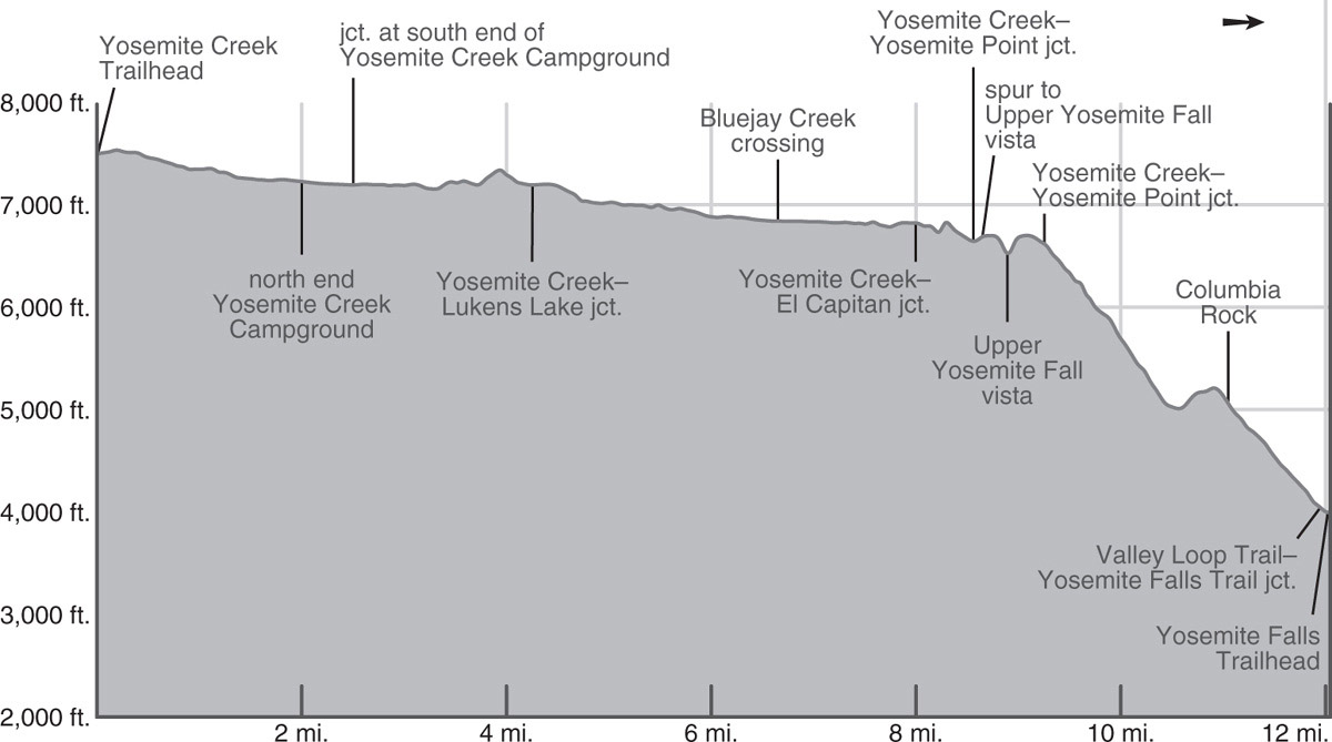
Upper Yosemite Fall Photo by Elizabeth Wenk
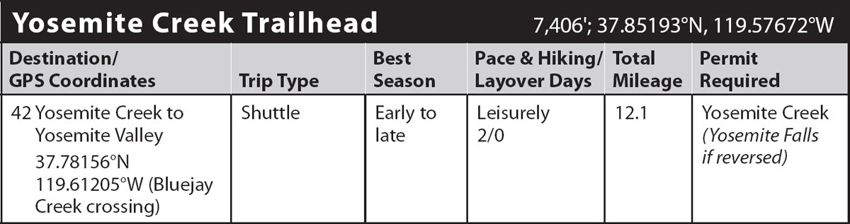
DAY 1 (Yosemite Creek Trailhead to Bluejay Creek, 6.5 miles): Departing from the western corner of the parking pullout, the trail soon bends south, following a lush gully at the base of granite bluffs. Jeffrey pines and fibrous-barked junipers cling to the shallow soils of slabs you cross, while lodgepole pines and red fir thrive in deeper soil pockets. After 0.9 mile of following the rambling trail well west of the river, you reach and ford wide Yosemite Creek—potentially quite dangerous from late May through June, if no convenient trees span the channel. The next 1.1 miles follow the creek’s east bank, alternating between flower-filled forest and sandy flats and eventually leading to the north end of Yosemite Creek Campground. (If you know it is a high-water year, an alternative start to this hike would be either to walk the campground road or to begin at the “Lukens Lake to Yosemite Creek Trailhead” farther west along CA 120 and follow that trail 3.3 miles south, merging with this hike’s description in paragraph 4 and avoiding the ford.)
Walking south along the campground’s eastern spur road, you first pass a junction with the old Tioga Road (too overgrown to follow; left, east), and after 0.5 mile recross Yosemite Creek on a bridge. Turning west, you pass a pit toilet and cross a smaller tributary, reaching the western side of the campground. Just beyond the tributary, the trail resumes, departing left (south) of the road.
The hike continues south along a sparsely forested shelf a short way west of the creek with views of the water tumbling down the granite-lined channel. The flower display can be showy, especially in late June when the magenta mountain pride penstemon lives up to its name. About a mile beyond the campground, the shelf peters out and you’ll climb up a ridge away from the creek. The route is across barren bedrock (and lightly burned in 2020) but is adequately marked. Large boulders resting atop polished slabs constitute evidence of the glaciers that descended from Mount Hoffmann to the northeast. From the ridge, you can look across the canyon and see a low dome that is exfoliating—shedding slabs of granite as a giant onion might peel its layers.
Short switchbacks guide you down from the ridge, then the trail heads west to three closely spaced creeks of a tributary canyon. Between the first and second is a junction with a lightly used trail, which heads 3.3 miles north to Tioga Road at the Lukens Lake parking area (the alternative, high water starting point). The flat you have just entered was partially burned by the Dark Hole Fire in 2014. You’ll note charred patches and adjacent intact conifer stands—this is an example of how a fire should burn, clearing some vegetation, but leaving many of the mature trees fairly unscathed. Lucky for hikers as well, the large camping area between the trail and creek is still shaded by live trees.
Descending steeply down a small gully, the trail again reaches the creek’s bank 0.5 mile beyond the junction. Small pools soon appear in the creekbed and farther downstream, the pools are interspersed with water-polished slabs. None of the pools is large enough for a swim, though many are suitable for a refreshing dip until the creek dries up in August. There are no good campsites along this stretch, but it is certainly delightful walking. A little over a mile later the gradient eases and the pervasive granite outcrops yield to larger forest patches. For the next mile, such as near (but not at) where Bluejay Creek flows into Yosemite Creek (6,842'; 37.78156°N, 119.61205°W), there are a selection of small campsites; if crossing Yosemite Creek is safe, there are other choices in forested flats on the east side of the creek.
DAY 2 (Bluejay Creek to Yosemite Valley, 5.6 miles): The next day, regain the trail, continuing downstream (south) toward Yosemite Valley. Beyond Bluejay Creek, the trail temporarily veers away from the river channel to skirt around a large gravel bar, then winds southeast to cross seasonal Eagle Peak Creek. A moderate-size campsite lies between it and Yosemite Creek, the last legal camping option along the route. You reach the junction 0.25 mile later with the trail traversing Yosemite Valley’s northern rim west to the Tamarack Flat Campground, visiting Eagle Peak and El Capitan. Your trail continues left (south), separated from Yosemite Creek by a series of knobs and climbs in and out of a succession of gullies, all in a straight line, undoubtedly indicative of a major fracture in the bedrock.
The final gully begins to drop more steeply and soon reaches a junction, where left (east) leads to the Upper Yosemite Fall vista and straight ahead (right; southwest) to Yosemite Valley. Not wanting to miss the superb vista from the rim, you turn left and make a brief climb to an adjacent broad crest with another junction, where right (south) leads to the Upper Yosemite Fall vista. Turn right and follow the spur trail south, almost reaching the valley’s rim, before you veer east (left) at a juniper and descend steps to a fenced-in viewpoint. Positioned beside the lip of Upper Yosemite Fall you see and hear it plunge all the way down its 1,430-foot drop to the rocks below
After returning up the crest you can briefly take a trail east to a bridge over Yosemite Creek and obtain water. However, be careful! Occasionally people wading in the creek’s icy water slip on the glass-smooth creek bottom and are swiftly carried over the fall’s brink—this has even occurred at low water flows. From the creek’s bridge you could also continue eastward an additional 1 mile up the trail to Yosemite Point, a highly scenic goal.
But, continuing the described route, from the brink of Upper Yosemite Fall, retrace your steps back to the main trail and begin your descent to Yosemite Valley. There are about 135 switchbacks along this trail, and the rocks jutting out of them are too often gravelly and slippery, so take it slow and watch your step, especially since you are wearing a backpack. The first stretch is down a brushy gully, out of sight of the falls, but eventually you trend left into a stand of oaks, bay trees, and Douglas-firs, all receiving some windblown moisture from Upper Yosemite Fall’s spray.
You switchback on down beneath forest cover and around here your first views of the fall—from below—appear. Exiting the forest cover again you traverse nearly due south at the base of tall, vertical cliffs, passing a winter closure gate, and immediately completing a single upward switchback.
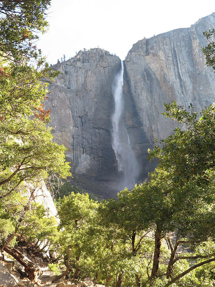
With 1.4 miles to go to trail’s end, you make a mostly shady traverse 0.35 mile to Columbia Rock. From the railing at Columbia Rock, at 5,031 feet elevation, you have a panoramic view of most of Yosemite Valley, from Half Dome and the Quarter Domes in the east to the Cathedral Spires in the west. This is the Goldilocks elevation for viewing Yosemite Valley—high enough that you appreciate its depth, but low enough that the rim and surrounding peaks still tower overhead. Embarking on a series of short, steep, switchbacks down an unstable, gravelly slope, you duck back into forest cover and traverse farther west before beginning the last leg of the trip, a mostly viewless descent zigzagging down under the shade of canyon live oaks and being annoyed by pesky gnats. The endless giant talus blocks are the result of past rockfalls; these fell long ago and are lichen and moss covered, but rockfalls occur annually in Yosemite, continually changing the landscape. The switchbacking ends at the intersection of the Valley Loop Trail, and, on it, you turn left (northeast) and walk the final 400 feet to the trailhead, located near the Camp 4 Walk-In Campground kiosk. If you have a car waiting for you somewhere in Yosemite Valley, the closest shuttle stop is 0.1 mile to the south, across Northside Drive, at the east end of the Yosemite Falls day-use parking area. The YARTS shuttle, with trips back up to the Yosemite Creek Trailhead, stops at the Yosemite Valley Visitor Center, reached by taking the Valley Shuttle to stop 9.
View from near Columbia Point to Yosemite Valley and Half Dome Photo by Elizabeth Wenk