INFORMATION AND PERMITS: These trips are in Yosemite National Park: wilderness permits and bear canisters are required; pets and firearms are prohibited. Quotas apply, with 60% of permits reservable online up to 24 weeks in advance and 40% available first-come, first-served starting at 11 a.m. the day before your trip’s start date. Fires are prohibited above 9,600 feet. See nps.gov/yose/planyourvisit/wildpermits.htm for more details.
DRIVING DIRECTIONS: The trailhead is located at Happy Isles, Yosemite Valley shuttle stop 16, along Happy Isles Loop Road. Because this road is closed to vehicular traffic, except the shuttle buses, use the shuttle bus or walk to reach the trailhead. Overnight hikers should park their cars at the hiker parking area, located along Happy Isles Loop Road about halfway between Curry Village and Happy Isles or in the large Curry Village parking lot. The Happy Isles shuttle stop is a 0.4-mile walk from the hiker parking area—from here it is more efficient to walk than to take the shuttle bus, while those in the main Curry Village lot should take the shuttle to the trailhead. There are water faucets and toilets at the shuttle stop.
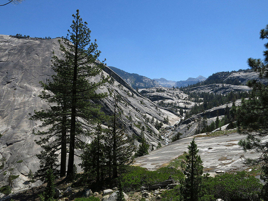
View up the Merced River Canyon toward Mount Florence Photo by Elizabeth Wenk
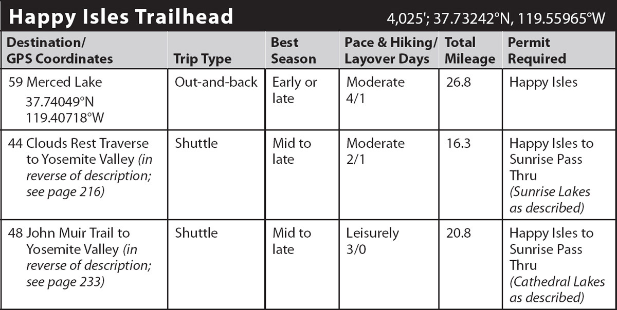
trip 59 Merced Lake
Trip Data: |
37.74049°N, 119.40718°W; 26.8 miles; 4/1 days |
Topos: |
Half Dome, Merced Peak |
HIGHLIGHTS: A good early-season trip (low altitude, early snowmelt), this route displays Yosemite’s scenic grandeur at its best, but it is never too crowded once past Little Yosemite Valley. As you follow the Merced River for more than 10 river miles you admire landscape shaped by glaciers and streams, the pale gray granite always dominating your thoughts.
HEADS UP! Though this trip is graded moderate, the first hiking day is rigorous, with more than 2,000 feet of hot, steady climbing.
HEADS UP! Permits for this trail are very hard to get, so consider two alternative starts. You can request a Happy Isles to Merced Lake Pass Thru permit, necessitating you hike an extra 2-plus miles on Day 1. Alternatively, you can begin at Glacier Point and follow the Panorama Trail until it intersects the John Muir Trail near the top of Nevada Fall, lengthening the first day by 2.4 miles but reducing the elevation gain. Note as well that if you obtain a standard Happy Isles to Little Yosemite Valley permit you must spend your first night in Little Yosemite Valley.
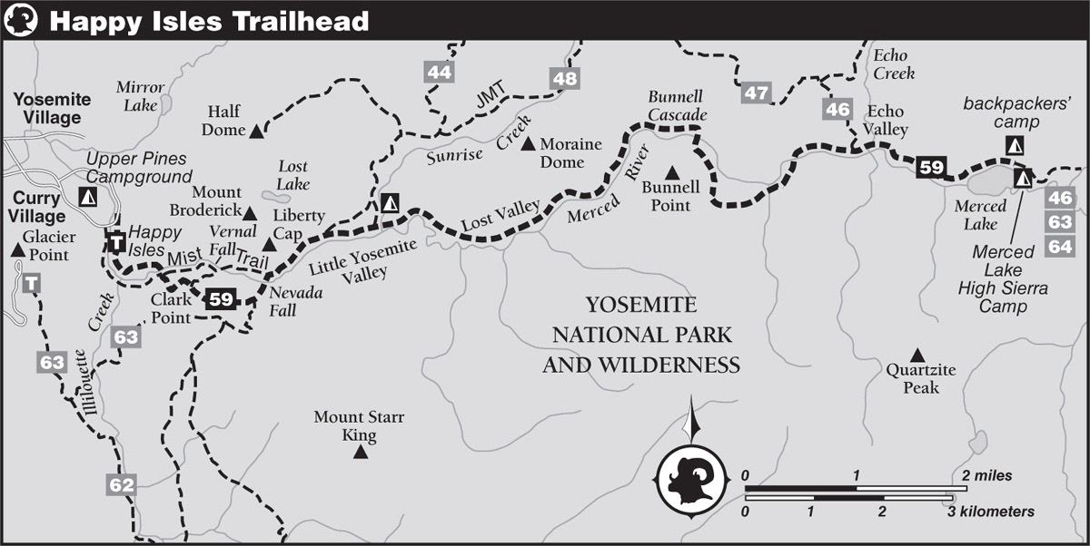
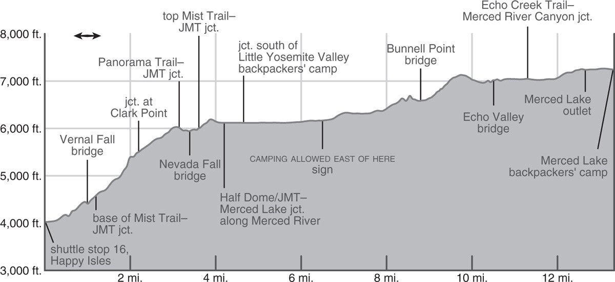
DAY 1 (Happy Isles to Little Yosemite Valley, 4.7 miles): From the Happy Isles shuttle stop you walk briefly east along the road across a bridge, then turn right (south) onto a trail and soon reach a sign proclaiming the start of the famous John Muir Trail (JMT). Winding past large boulders through a forest of oaks, California laurel, and conifers, your paved path takes you past a small spring-fed cistern, beyond which the climb steepens. At a distinct left bend in the trail, look west at the decimated forest at the base of Glacier Point Apron, the aftermath of a massive rockslide in July 1996. The deposit of boulders lies close to the cliff wall, and beyond is a ring of trees, toppled by the air blast that accompanied the slide—the giant, largely intact rock slabs were tumbling at an astonishing 270 miles per hour by the time they reached the valley floor. Entering forest shade once more, you ascend a steep stretch of trail before making a quick drop to the Vernal Fall bridge. From it you see Vernal Fall, a broad curtain of water plunging 320 feet over a vertical cliff before cascading toward you. Looming above the fall are two glacier-resistant masses, Mount Broderick (left) and Liberty Cap (right). Just beyond the bridge are a drinking fountain and water faucet, with a toilet a few steps farther along.
Now you continue up to the start of the Mist Trail. The 0.8-mile-shorter Mist Trail leads to the brink of Vernal Fall, past Emerald Pool, and across the Silver Apron. It is certainly worth taking, but the stairs ascending the steep stretch to the top of Vernal Fall are no fun with an overnight pack, especially if you are trying to race upward to avoid drenching yourself and all your gear, a spring and early summer scenario. Instead you turn right (southwest), continuing along the JMT corridor, a route yielding different rewards. One is that the miles to Clark Point are along shady, moderately graded switchbacks. Above Clark Point you have spectacular views across the canyon to Half Dome, Mount Broderick, and Liberty Cap, rising to the left of downward-leaping Nevada Fall. Where a stretch of trail has been blasted out of the steep granite slab, a tall wall provides safe passage.
Beyond this section you intersect the end of the Panorama Trail, which started at Glacier Point. Stay left (northeast) at a pair of spurs and descend to the bridge over Nevada Fall. About 100 feet north of the bridge, a cryptic spur trail drops northwest to a viewpoint beside the fall’s brink. Back on the main trail, you descend briefly and reach the top of the Mist Trail, where hikers opting for this shorter, steeper trail will rejoin this route description.
From the junction and its adjacent outhouses, you begin the final climb to Little Yosemite Valley, first by ascending a brushy, rocky slope and then briefly descending and reaching both forest shade and the Merced River. Beneath pines, firs, and incense cedars, you continue northeast along the river’s azalea-lined bank, soon reaching a trail fork. Bound for Merced Lake, you keep right (east) on the main, riverside trail and continue just out of sight of the river’s edge, to reach a junction at the southern edge of the Little Yosemite Valley backpackers’ camp (6,120'; 37.73196°N, 119.51536°W). Turn left (north) and within steps you’ll see the tent city to the right where you will spend your first night. There are toilets and food-storage boxes; a usually-staffed ranger station is hidden to the northeast of the camping area.
DAY 2 (Little Yosemite Valley to Merced Lake, 8.7 miles): Return to the junction south of the backpackers’ campground and turn left (east). With the majority of hikers heading toward Half Dome or along the JMT, the trail leading north out of Little Yosemite Valley, your route is now much quieter—and wonderfully flat.
Most of the forest in eastern Little Yosemite Valley and Lost Valley (the next valley east) was burned in the Meadow Fire in September 2014. Previously much of this section had been a dense forest, with abundant dead material on the ground, providing ample fuel for the fire to spread; this is a natural process and was caused by a natural lightning-strike fire, but the lack of shade and loss of beautiful canopy trees is nonetheless unwelcome on a hot day. Trying to be optimistic, you now have a better view of the canyon’s walls and can admire the blackened tree trunks as artistic totems. A thick accumulation of glacial sediments covers most of the valley floor, which, like beach sand, makes for harder walking even though the trail is level.
Most of Little Yosemite Valley is a designated day-use area and only once you’re beyond a sign in the eastern stretches of the valley may you camp. The valley’s east end is graced by the presence of a beautiful pool—the receptacle of a Merced River cascade; this has always been a popular camping area but is now badly charred, although it’s still in use as a campsite. Climbing slabs past the cascade, you round the base of a glacier-smoothed dome, unofficially called Sugarloaf Dome, and enter Lost Valley, the next flat valley. This valley has also been scorched by the Meadow Fire, with barely a tree still standing. At the valley’s east end, where Bunnell Point and an unnamed dome to the north pinch the valley closed, switchback up past Bunnell Cascade on bare slabs straight above the churning river.
GEOLOGY LESSON
As an indication of how deep glaciers were here, look up at Moraine Dome to the east: ice filled the valley almost to its summit 750,000 years ago. Since then, glaciers have repeatedly entered this valley, but none have been that thick.
Just past the gorge, the canyon floor widens a bit, and, just before a pair of bridges cross the Merced, if you trend east (left) from the trail, you will find a small, beautiful camping area atop some slabs. The trail follows the south bank briefly upstream, but it soon diverges from the water’s edge and climbs more than a dozen switchbacks that carry you 400 feet above the river. Your climb reaches its zenith amid a spring-fed wildflower garden bordered by aspens; in midsummer enjoy the colorful array underfoot and in fall the brilliant yellow and orange leaves overhead.
Beyond this glade, you cross a highly polished bedrock surface, then descend back into a grove of white-trunked aspens and cross several creeklets before emerging on a bedrock bench above the river’s inner gorge. From the bench, you can study an immense arch on the broad, hulking granitic mass opposite you and watch the water churning below. Traversing the narrow trail, you soon come to a bridge that crosses the Merced just above the brink of these cascades. Strolling east leads to spacious Echo Valley. You pass a few sandy knobs harboring campsites, then reach a junction with a trail ascending Echo Creek (left; north); bear right (east) here, heading toward Merced Lake.
You immediately cross Echo Creek’s braided river channels on three bridges, then strike southeast through the boggy eastern half of Echo Valley, a dense tangle of approximately 15-foot-tall lodgepole pines, regenerating after fires in 1988 and 1993; the combination of downed logs and thickets of young trees make camping implausible. After mounting a shelf at the east end of Echo Valley, you again reach the river’s edge. There are some small campsites north of the trail here, some in sandy flats among slabs and others in small lodgepole pine stands. Continuing on slabs beside the foaming river, you reach Merced Lake’s outlet, at which there are no suitable campsites, and continue around Merced Lake’s northern shore to the designated backpackers’ camping area (7,242'; 37.74049°N, 119.40718°W), just a little northeast of the lake. This is the only legal camping option along the shores of Merced Lake. Pit toilets and food-storage boxes are an added bonus. Eighty-foot-deep Merced Lake supports three species of trout: brook, brown, and rainbow. The Merced Lake High Sierra Camp is another 0.15 mile east along the trail, if you’d like to take a look or fill your water bottles at their faucet.
DAYS 3–4 (Merced Lake to Happy Isles Trailhead, 13.4 miles): Retrace your steps.

The Merced River’s bedrock base, just downstream of Merced Lake Photo by Elizabeth Wenk