INFORMATION AND PERMITS: This trailhead is in Humboldt-Toiyabe National Forest, accessing Hoover Wilderness. Wilderness permits are required for overnight stays and quotas apply from the last Friday in June through September 15. Fifty percent of permits can be reserved in advance through recreation.gov (search for “Humboldt-Toiyabe National Forest Wilderness Permits”), and 50% are available on a first-come, first-served basis at the Bridgeport Ranger District office beginning at 1 p.m. the day before your trip starts. Both reserved and first-come, first-served permits are picked up at the Bridgeport Ranger Station, located at 75694 US 395 at the south end of Bridgeport. If you want the ranger station to leave a reserved permit in their dropbox for you to pick up outside of office hours, call 760-932-7070. Visit tinyurl.com/hooverwildernesspermits for more information on reserving permits. Bear canisters are required. Campfires are prohibited above 9,000 feet in the Virginia Lakes and Green Creek basins.
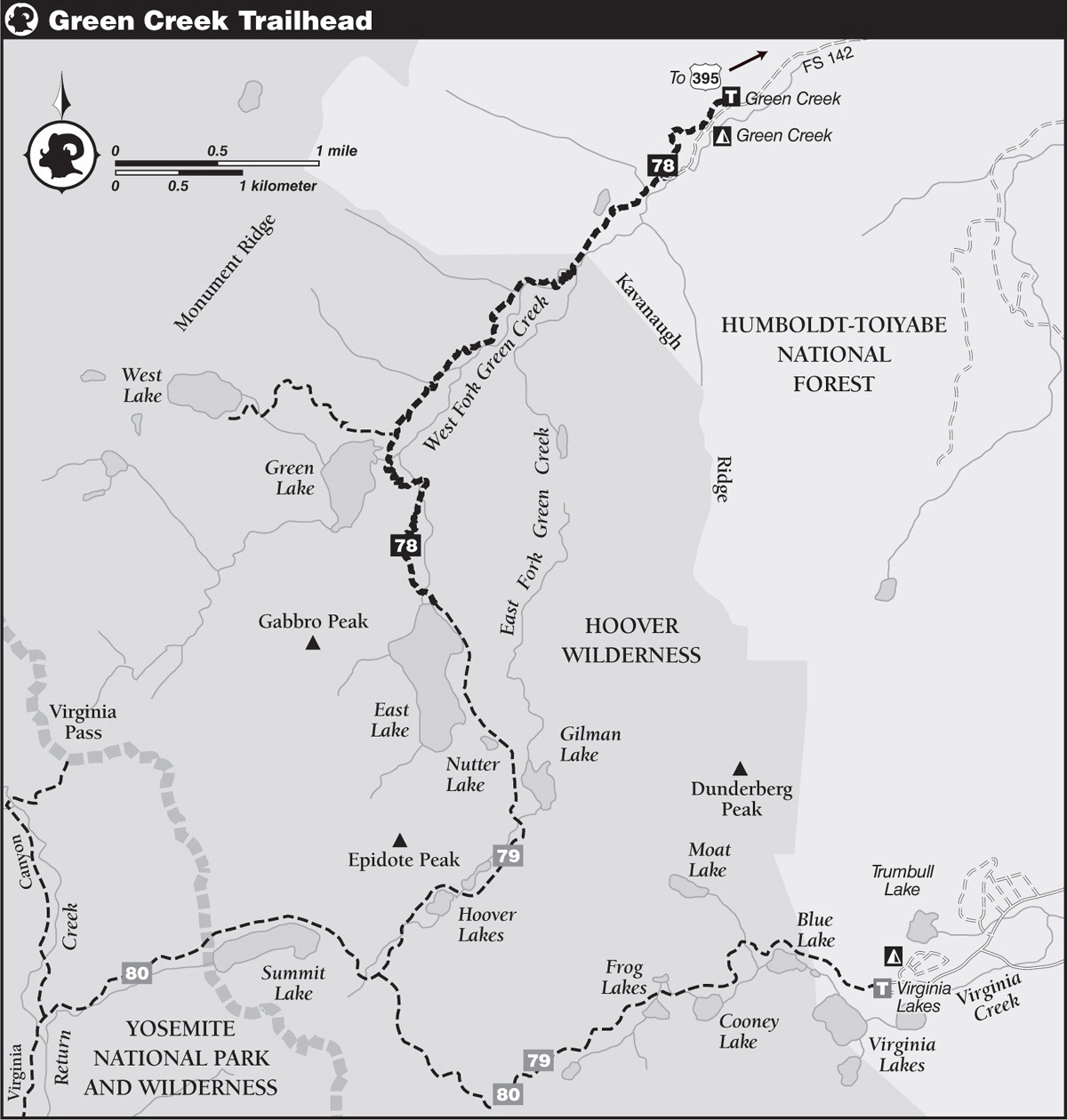
DRIVING DIRECTIONS: From Bridgeport, drive south on US 395 through the town to the Bridgeport Ranger Station, near its south edge. Continue 3.8 miles south on US 395 to a junction with Green Creek Road, Forest Service Road 142. If you’re traveling north on US 395, you’ll meet this junction about 8.1 miles north of US 395’s Conway Summit. Turn west and take FS 142 about 3.5 miles to a T. At the T you branch right, still on FS 142, and go 5.1 miles to an obvious trailhead parking area on the right. There is an outhouse and a water spigot. (Just 300 feet past this is the Green Creek Campground. You first pass the group sites, on the left, and 0.25 mile farther you enter the campground proper.)
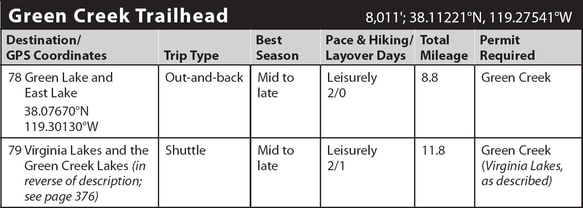
trip 78 Green Lake and East Lake
Trip Data: |
38.07670°N, 119.30130°W; 8.8 miles; 2/0 days |
Topos: |
Dunderberg Peak |
HIGHLIGHTS: This is a fine beginner’s weekend hike. East Lake’s scenery includes three colorful peaks, Gabbro, Page, and Epidote, each of which are composed of rocks varying in hue from vermilion reds to ochre and set in metavolcanic blacks for contrast. Nearby Nutter, Gilman, and Hoover Lakes offer good fishing to supplement the angling in East Lake, and the wide-ranging scenery along the way rivals any found on longer backpacking trips.
DAY 1 (Green Creek Trailhead to East Lake, 4.4 miles): From the back of the trailhead parking area, the trail diverges north from the road to encircle the Green Creek Campground through a moist aspen glade. The trail winds and undulates upcanyon before reintersecting Green Creek Road. The trail now temporarily ends and you must continue up the road 0.3 mile to its end at a small private cabin and a step-across trickle. Leaving the giant Jeffrey pines that grace the roadsides, the proper trail now begins its multistep ascent.
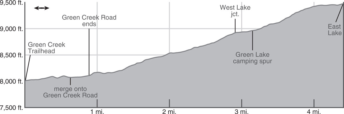
With a few steep switchbacks you quickly surmount a dry, juniper-dotted rocky knob and continue through open forest above the creek, the terrain alternating between brief, steep climbs and flatter benches. Whereas you started up slopes dominated by Jeffrey pines, you now ascend through a damp forest of lodgepole pines and aspens. At 1.3 miles you cross into Hoover Wilderness and climb a dozen short, rocky switchbacks.
Above the switchbacks, you pass beside a marshy flat, the confluence of Green Creek’s two forks, and above encounter a stretch of lushly vegetated trail, irrigated by both a small tributary descending the steep slope to the right and Green Creek itself. Just muddy enough to be a possible nuisance for some early- and midsummer hikers, the trail cuts through a swath of luxuriant wildflowers that dazzle the eye with their myriad colors: orange alpine lilies, lilac fireweed, purple monkshood, and violet larkspur. In fall this stretch of trail is equally colorful; the aspens are not much taller than a person, so you are literally in the middle of their bright yellow and orange canopies.
For a stretch the trail’s meanders match those of the unseen creek, but then you diverge from the drainage and complete a couple of switchbacks to reach a dry ridge dotted with juniper trees. For the first time you now have unbroken views of the surrounding mountains and back down Green Creek. Just ahead you’ll arrive at a trail junction. To the right (west) is a trail that provides access to the northwest shore of Green Lake and to West Lake and its western outliers, while you will turn left (south) and make a brief jaunt 0.2 mile to a crossing of Green Lake’s outlet creek. In spring and early summer this creek can be raging and hikers should cross it on a logjam downstream of the stock crossing. Just after this creek, you can head west to the lake to some good campsites and picnic spots. At an elevation of 8,940 feet, Green Lake can be on the nippy side for swimming, but there are slabs for drying out and sunbathing, and the cool waters support a good-size trout population.
Continuing on the main trail, you have another 1.3 miles to East Lake, a moderate ascent through a relatively dense conifer forest. Partway up you’ll cross the lake’s outlet creek, which in early summer can be swift—take care not to slip into its cascading course. Above, you recross it, a broad ford negotiated on big rock blocks. After about a 500-foot elevation gain (from Green Lake) the grade becomes more leisurely and you soon reach a third crossing. Just beyond is East Lake (9,476'; 38.07670°N, 119.30130°W; no campfires; the mileage is measured to here). This is a large subalpine lake, fully 0.75 mile long, and the trail parallels its east side for most of its length. From the outlet south to the southeast shore, there are scattered, usually small campsites on granite benches shaded mostly by whitebark pines. Fishing for rainbow trout on this 75-acre lake is good. This lake makes a fine basecamp for forays to nearby Nutter, Gilman, and Hoover Lakes.
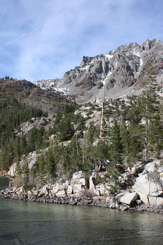
Green Lake Photo by Elizabeth Wenk
DAY 2 (East Lake to Green Creek Trailhead, 4.4 miles): Retrace your steps.