TRIP 14 Mt. Burdell Open Space Preserve
| Distance | 5.6 miles, Semi-loop | |
| Hiking Time | 3 to 4 hours | |
| Elevation Gain/Loss | ±1200 feet | |
| Difficulty | Moderate | |
| Trail Use | Mountain biking allowed1, Leashed Dogs | |
| Best Times | Fall through spring | |
| Agency | MCOSD | |
| Notes | 1Bicycles are not allowed on the Michako Trail, and must instead use the San Carlos, San Marin, and Big Tank fire roads to complete the trip |
HIGHLIGHTS This trip, using the San Andreas, Middle Burdell, Cobblestone, San Carlos, and Big Tank fire roads, and the Michako Trail, explores the open grasslands, groves, and high ground of Burdell Mountain, a bulky ridge that rises to 1558 feet and dominates the northeast corner of Marin County. The mountain’s southern flank is designated Mt. Burdell Open Space Preserve, and in spring its grassy slopes and oak woodlands come alive with carpets of wildflowers and a chorus of birdsong.
DIRECTIONS From Highway 101 in Novato, take the Atherton Ave./San Marin Dr. exit. Go west 2.2 miles on San Marin Dr., turn right onto San Andreas Dr., and go 0.6 mile to where the road makes a sweeping bend to the left. Park on the shoulder and observe the NO PARKING signs.
FACILITIES/TRAILHEAD There are no facilities at the trailhead, which is located at the foot of the San Andreas Fire Road, just northeast of the parking area.
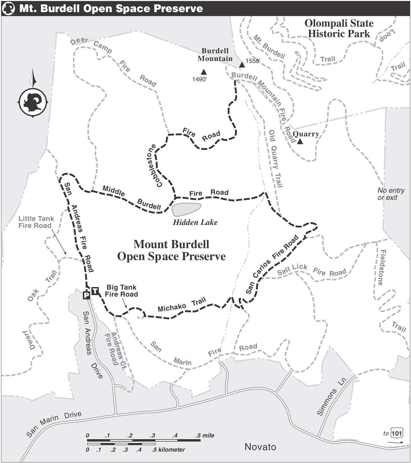
At the foot of the San Andreas Fire Road, which is gated and locked, head east on a dirt path and, in about 50 feet, go through a gate and then turn sharply left. After 100 feet or so, you merge with the San Andreas Fire Road, which climbs on a gentle grade. About 75 feet ahead, you pass the Big Tank Fire Road, signed BIG TANK FIRE TRAIL, which you will use on your return. Your route here is part of the Bay Area Ridge Trail, and it is popular with local residents, their horses, and their dogs.
Soon you pass a single-track trail heading left through an opening in a barbed-wire fence. The area behind the fence, also part of Mt. Burdell Open Space Preserve, is designated a Sensitive Wildlife Area, where dogs are not allowed. Now climbing on a moderate grade, you pass another trail, left, signed TO LITTLE TANK FIRE ROAD. About 75 feet farther, you pass through an opening in a fence.
Passing a concrete wall, right, you come to a clearing that affords a view of Burdell Mountain’s summit ridge and the communication tower perched just below it. The middle ground of this beautiful scene is composed of rolling hills studded with oaks. The foreground, in spring, may be carpeted with California buttercup and owl’s-clover.
Soon you meet a junction, left, with the Dwarf Oak Trail. During and just after the rainy season, the open ground surrounding the junction is a marshy area, home to red-winged blackbirds, western bluebirds, and a wildflower called Douglas meadowfoam, which sports five yellow petals tipped with white. A few hundred feet farther, you pass two unofficial trails, right.
As you continue walking on a gentle downhill course, you are surrounded by open, grassy fields, and rising, rolling hills. The main ridge of Burdell Mountain trends east–west, and is topped with many rounded summits.
Soon the road reaches a low point, then bends left and begins to climb. In a shady grove of valley oak, an unofficial trail departs uphill and right, but you continue straight. In about 50 feet, you come to a junction marked by a trail post. Here, the San Andreas Fire Road heads left, and your route, the Middle Burdell Fire Road, also part of the Bay Area Ridge Trail, goes straight.
Mountain Moniker
The mountain was named for Galen Burdell, one of the first dentists in San Francisco, who lived with his wife, Mary, just north of here, in what is now Olompali State Park. The couple received the land in 1863 as a wedding present from Mary’s father, James Black, one of Marin County’s largest landowners.
Now the road, still rising, splits at a fork and then rejoins. In a grove of oak and buckeye, you pass the Deer Camp Fire Road, left. Your route follows a barbed-wire fence and a streambed, both right. Passing a single-track trail, right, you reach level ground and a T-junction. Here, at about 1.5 miles, the Middle Burdell Fire Road turns right, and the Cobblestone Fire Road, the way to the top of Burdell Mountain, heads left. (If you do not wish to make the approximately 700-foot, 1-mile climb, turn right and pick up the directions below to complete the trip.)
Turning left, you begin climbing on a moderate grade, past grassy fields full of California poppies and bluedicks. The route gets steeper and rockier, but you are rewarded by terrific views west toward Bolinas Ridge, and southeast to San Pablo Bay and the peninsula that holds China Camp State Park. As the grade eases somewhat, you pass through groves of coast live oak and bay, offering welcome shade on a warm day.
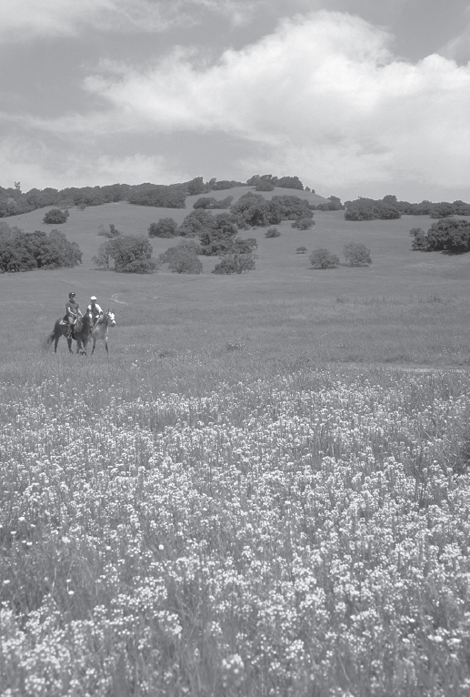
Equestrians ride on the San Andreas Fire Road at Mt. Burdell Open Space Preserve.
Soon you come to a fork where the Deer Camp Fire Road branches left and the Cobblestone Fire Road veers right. Stay right, and as you gain elevation, the communication tower near the summit of Burdell Mountain comes into view. The upper slopes of the mountain host dramatic displays of wildflowers in spring, and this area may be full of wild irises.
Now the road turns north, trying to find the easiest way up Burdell Mountain. The climbing is moderate, with a few level areas to ease your efforts, and some groves of bay and coast live oak for shade. Your view extends south, across the housing developments of Novato, all the way to triple-peaked Mt. Tamalpais.
As you climb, ignore the faint trails that diverge from the main route. The communication tower, once a distant feature, is now to the left and just slightly uphill. There is higher ground ahead, but the true summit of Burdell Mountain (1558’) is just beyond the preserve boundary, unreachable, on private land.
Nearing the end of the climb, you come to a junction with the Old Quarry Trail, right, and, almost immediately, a T-junction with the Burdell Mountain Ridge Fire Road, a paved road. The preserve’s high point lies just ahead, across the road and at the end of a faint single-track trail that heads north and uphill through the grass, which is dotted blue with larkspur.
Burdell Mountain Rocks
A rock wall, reminiscent of New England but actually built by Chinese laborers who worked in a nearby quarry, marks the preserve boundary. The quarry, which produced rocks used for cobblestone streets, is about 0.25 mile southeast on the Burdell Mountain Ridge Fire Road. A rough path heads left from the road, through trees and brush, to the quarry.
Birds in the Bush
Passing through a wooded area, you may be startled by a flock of band-tailed pigeons taking flight. These cousins of the urban pigeon are large, beautifully marked birds that favor forested areas, where they often gather in large flocks. When disturbed, they leave their perches singly at first, and then in increasingly larger groups until the whole flock has departed.
After exploring Burdell Mountain’s high ground, retrace your route to the junction of the Cobblestone and Middle Burdell fire roads. Here, about 3.5 miles, you continue straight, now back on the Middle Burdell Fire Road, and pass Hidden Lake, a large vernal pool on your right, which may hold ducks, egrets, and other water-loving birds. Growing around the lake are at least 10 species of rare plants, including white water-buttercup, pale navarretia, and yellow linanthus.
Your route now heads east over level ground, with open, grassy slopes sweeping uphill on your left. Dipping into and then out of a small wooded ravine, you soon pass a junction, left, with the Old Quarry Trail. Several hundred feet past this junction, the continuation of the Old Quarry Trail heads right, but you continue straight.
Soon you reach a junction and a watering trough for animals, where the Middle Burdell Fire Road continues straight, and your route, the San Carlos Fire Road, turns right. Descending gently for about 75 feet, you come to a gated fence. After passing through the gate, you descend past the Old Quarry Trail, right, and, about 350 feet ahead, pass the Salt Lick Fire Road, left.
Continuing straight and downhill on the San Carlos Fire Road, your route soon veers right, and then makes a sharp left-hand bend. At a four-way junction, where the San Carlos Fire Road continues straight and a faint trace heads left, you turn right onto the Michako Trail, a single track, which is closed to bicycles. Still descending, you pass through an opening in a fence, cross a seasonal creek via some rocks, and then find level ground.
Just past the creek, a faint trail heads left, but you continue straight and soon begin a gentle climb. Now a trail joins sharply from the left, and then you cross another seasonal creek. In about 100 feet, the route forks and you bear left, soon crossing yet another creek, this one the site of a stone hut, once used to protect a freshwater spring. After another 150 feet or so, your route is joined by a trail, right, coming from the previous fork.
Soon you come to a four-way junction, where the Big Tank Fire Road crosses the Michako Trail. Here you continue straight across a grassy field, and, in about 200 feet, come to a watercourse that, when flowing, has a series of delightful miniature waterfalls. Once across this watercourse, you soon reach the next junction, where the Michako Trail merges with the San Marin Fire Road, coming from the left. About 25 feet past this spot, you reach a junction with the Big Tank Fire Road, joining from the right.
From here, you continue straight, now on the Big Tank Fire Road. Now the route forks, with the main road bending left and descending, and a single-track heading right. You bear left, passing a few homes and the San Andreas Court Fire Road, left. Your route now swings right, climbs, and is soon joined by the single-track trail coming from the previous fork.
Now on an easy descent, you pass a landslide area where the road may have disappeared. If so, follow a narrow path next to the embankment, where a creek flows under the roadbed through a culvert. About 100 feet ahead is the junction with the San Andreas Fire Road you passed at the start of this loop. Turn left here and retrace your route to the parking area.