TRIP 17 Point Reyes National Seashore: Mt. Wittenberg
| Distance | 5.1 miles, Semi-loop | |
| Hiking Time | 2 to 3 hours | |
| Elevation Gain/Loss | ±1300 feet | |
| Difficulty | Moderate | |
| Trail Use | Backpacking option1 | |
| Best Times | All year | |
| Agency | NPS | |
| Recommended Map | Point Reyes National Seashore South District Trail Map (NPS) | |
| Notes | 1Sky Camp, a hike-in campground, is on the Sky Trail, northwest of its junction with the Mt. Wittenberg Trail. For reservations, call (415) 663-8054 weekdays from 9 A.M. to 2 P.M. |
HIGHLIGHTS Using the Bear Valley, Mt. Wittenberg, Sky, and Meadow trails, this athletic loop takes you up Inverness Ridge to the summit of Mt. Wittenberg, the highest point in Point Reyes National Seashore. No reason other than the joy of hiking is needed to try this route, but further inducements include a wonderful variety of plant and bird life, and great views. Be sure to check with rangers at the visitor center for the latest trail conditions and closures.
DIRECTIONS From Highway 1 northbound in Olema, just north of the junction with Sir Francis Drake Blvd., turn left onto Bear Valley Road and go 0.5 mile to the visitor-center entrance road. Turn left and go 0.2 mile to a large paved parking area in front of the visitor center. If this area is full, there is a dirt parking area ahead and left.
From Highway 1 southbound in Point Reyes Station, go 0.2 mile from the end of the town’s main street to Sir Francis Drake Blvd. and turn right. Go 0.7 mile and turn left onto Bear Valley Road. At 1.7 miles you reach the visitor-center entrance road; turn right and follow the directions above.
FACILITIES/TRAILHEAD A visitor center with displays, books, maps, and helpful staff is located next to the parking area, along with picnic tables, restrooms, phone, and water.
The Bear Valley trailhead is at the end of the paved entrance road, about 150 feet south of the paved parking area.
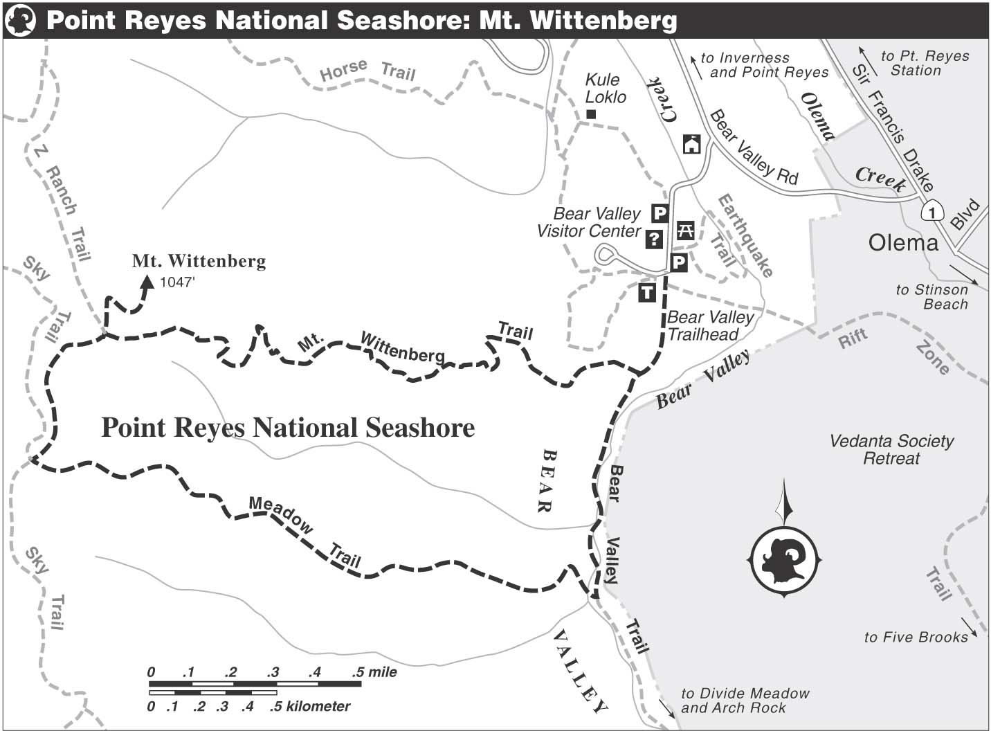
The Bear Valley trailhead is one of the busiest in Point Reyes National Seashore, giving visitors access to the heart of this wonderful area. Hikers, bikers, and equestrians share the main thoroughfare, a dirt road called the Bear Valley Trail, for most of its length; but bicycles are not allowed past its junction with the Glen Trail, about 0.8 mile short of the coast, and horses are not allowed on weekends and holidays.
After walking through a gap in a wooden fence that marks the trailhead, you pass the Rift Zone Trail, left, and the Woodpecker Trail, right. Coming over a low rise, you make a gentle descent to a junction with the Mt. Wittenberg Trail, a single track. Here you turn right, walking under the outstretched limbs of a large, lichen-draped California bay tree. The trail, now rough and rocky, widens and steepens, taking you uphill on a moderate grade.
The Birds and the Trees
Acorn woodpeckers are common here — a good place to spot them is in the oak-shaded picnic area, just east of the visitor center. Look for a robin-sized bird, black with white wing patches, a white rump, and a red cap on its head. These busy birds collect fallen acorns and then stuff them one by one into holes they have drilled in the trunk of a tree.
The forest here, with bay, tanbark oak, hazelnut, evergreen huckleberry, and western sword fern, resembles a coast redwood forest with one exception — no coast redwoods. The San Andreas fault defines the western limit of these trees in Marin County, perhaps because the granitic soil on the Point Reyes peninsula is unsuitable for them. Instead of redwoods, there are tall Douglas-firs.
Short level stretches relieve the otherwise constant climbing, and the variety of plants provides ample reason to stop often and study your surroundings. After several switchbacks, you come to a clearing filled with young Douglas-firs. Before long, this clearing, and others like it, may be indistinguishable from the mature forest that blankets Inverness Ridge. Narrowing to single-track width, the trail leads uphill on a moderate grade and returns to dense forest.
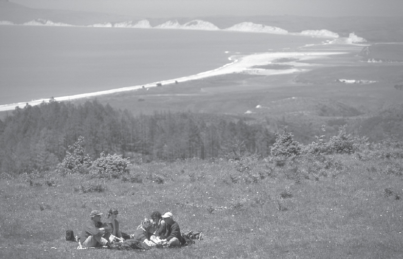
Open slopes below Mt. Wittenberg offer great picnicking spots with superb views.
Now the trail makes a series of switchbacks to gain the crest of a ridge. You break out of the forest at last and cross an open field, with Mt. Wittenberg rising to the right. At about 2 miles, you reach a junction, where a short trail to Mt. Wittenberg’s summit, which is closed to horses, goes sharply right and uphill. Here too is the Z Ranch Trail, going right on a level grade. Also from this junction, the continuation of the Mt. Wittenberg Trail veers slightly left. The mountain is named for a rancher who once lived nearby, not for Hamlet’s alma mater.
To reach the summit of Mt. Wittenberg, at 1407 feet the highest point on Inverness Ridge, turn sharply right and begin a moderate climb. After about 0.2 mile you arrive at the summit, where you have fine views of the Point Reyes peninsula, the Olema Valley, Mt. Tamalpais, and, on a clear day, other landmarks to the east, south, and southwest. The summit is a broad clearing bordered by an arc of trees that stretches from north to west, blocking views in those directions.
After enjoying the summit, return to the junction and continue on the Mt. Wittenberg Trail, now descending on a gentle and then moderate grade, with a steep hillside dropping right. The view here extends west and southwest into the zone blackened by the October 1995 Vision Fire, where the once-dominant bishop-pine forest is reestablishing itself. Beyond are Limantour Estero, Drakes Beach, and the great curving arm of the Pt. Reyes peninsula itself.
After a pleasant downhill ramble, the Mt. Wittenberg Trail ends, and you merge with the Sky Trail by bearing left. It was this trail, a dirt road, that finally blocked the fire’s path after it had burned for three days and charred more than 12,000 acres. About 50 feet past the junction, you leave the Sky Trail and turn left onto the Meadow Trail, a single track. At first on a level course, the trail soon begins a descent that alternates between gentle and moderate. The route suddenly breaks out of the trees and crosses a wide meadow, with a lovely view straight ahead of Mt. Tamalpais.
At the end of the meadow, the route returns to forest and begins a winding descent, often steep, over eroded, root-crossed ground. The trail levels when it reaches a low divide, and then resumes its plunge off Inverness Ridge into Bear Valley. The sound of running water indicates Bear Valley Creek, which you cross via a wooden bridge. Just ahead is a junction with the Bear Valley Trail, where you turn left. Passing a rest bench, right, you soon arrive at the junction with the Mt. Wittenberg Trail. Continue straight and retrace your route to the parking area.