TRIP 6 Rush Ranch
| Distance | 2.2 miles, Loop | |
| Hiking Time | 1 to 2 hours | |
| Difficulty | Easy | |
| Trail Use | Good for kids | |
| Best Times | Fall through spring | |
| Agency | SLT | |
| Recommended Map | Rush Ranch Marsh Trail Guide (Rush Ranch Educational Council) |
HIGHLIGHTS Acquired in 1988 by the Solano County Farmlands and Open Space Foundation (now Solano Land Trust), this ranch has more than 2000 acres of significant habitat, including a more than 5-mile-long boundary between wetlands and upland grasslands. There are a dozen rare or endangered species here, including the clapper rail, the salt marsh harvest mouse, and the Delta smelt. An easy loop along the self-guiding Marsh Trail lets you sample some of this protected open space.
Boldface numbers in the route description refer to numbered markers along the trail, which are keyed to the Rush Ranch Marsh Trail Guide pamphlet, available at the visitor center, or online at www.rushranch.org.
DIRECTIONS From I-80 in Fairfield, take the exit for Highway 12, also signed for Rio Vista and Suisun City. At 4.2 miles, turn right on Grizzly Island Road and go 2.4 miles to the ranch entrance, right. Go 0.2 mile to a large gravel parking area, left.
FACILITIES/TRAILHEAD There are picnic tables and toilets near the parking area. A visitor center with displays, brochures, and other information is a few hundred feet southwest of the parking area, just past the livestock corrals. Other ranch buildings and displays of farming equipment are nearby. The trailhead is just left of the visitor center, a small white building.
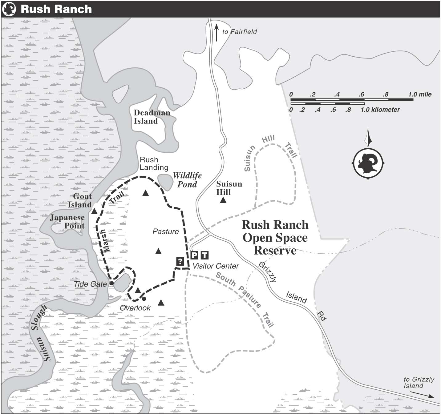
You head west through a grove of eucalyptus, marker 1, a nonnative species from Australia planted extensively in the Bay Area. Although unsuited for lumber, the trees provide windbreaks and habitat for some birds and small mammals. Marker 2, just ahead, is for the transition zone between the coastal plain and the Central Valley. Joined on the left by a dirt road, you veer right and enjoy a level walk.
Once through a gap in a barbed-wire fence, you climb on a gentle grade to a junction, where a short trail goes right to an overlook atop a hill with 360-degree views that reach from Mt. Diablo and Suisun Marsh northward to the Vaca Mountains. Circling clockwise around the hill, marker 3, you come to marker 4, for the boundary, or ecotone, between grasslands and salt marsh. Passing a reconstructed Native American tule house and a road, left, you enter a managed wetland, marker 5. Beginning in the late 1800s, this area was managed for farming and waterfowl through the regulation of water by tide gates.
Now on a rough path atop a levee, you pass marker 6, where otters sometimes cross from the managed marsh, right, to the salt marsh, left. Other mammals found here include skunks, raccoons, and opossums. The blackberry vines, marker 7, are not marsh plants, so their seeds were probably deposited here by birds or the wind. Marker 8 is for one of the many tide gates that regulate water flow seasonally into and out of the marsh. Cattails and tules, marker 9, are common marsh plants. Across Suisun Slough, marker 10, is more of Rush Ranch and the buildings of a private hunting club.
Common reed, also called phragmites, marker 11, is a tall plant found in fresh or brackish water. Marker 12 indicates Goat Island and a viewpoint on the bluff above. Marker 13 is for the rocks, or riprap, that reinforce the levee. Climbing over a barbed-wire fence via a stile, you come to marker 14, indicating the outflow tide gate you just passed. Turning left, you follow a faint dirt road through grassland, marker 15. Slightly higher elevation makes it harder for marsh water to flood this area, and this creates a habitat that is different from the one you just left.
The Birds & the Flowers
More than 120 species of birds have been recorded at Rush Ranch, with the best birding being in winter. In addition to ducks, geese, and shorebirds, the ranch is home to many common songbirds, including the red-winged blackbird, northern mockingbird, western meadowlark, marsh wren, and mourning dove. Grassland flowers here include California poppies, blue-eyed grass, California buttercup, lupine, and butter-and-eggs. Growing in the marsh are pickleweed, saltgrass, jaumea, brass buttons, and fat hen.

Farm buildings and displays of old farming equipment greet visitors to Rush Ranch.
With the Potrero Hills ahead, you pass a rest bench and climb gently to marker 16. From here, you can see Rush Landing, a cove where boats from San Francisco and Sacramento used to land. A path from marker 17 heads north toward Hill Slough. The trail bends right and passes a wildlife pond, marker 18, fed by a spring and also by runoff from Suisun Hill. Nonnative Harding grass, marker 19, was planted here in the 1940s as forage for cattle. This grassland habitat, marker 20, provides habitat for rodents, which are prey for raptors and owls. Marker 21, near the parking area, is for a small horse stable, one of several ranch buildings.