TRIP 10 Windy Hill Open Space Preserve: Spring Ridge
| Distance | 7.6 miles, Loop | |
| Hiking Time | 4 to 5 hours | |
| Elevation Gain/Loss | ±1400 feet | |
| Difficulty | Difficult | |
| Trail Use | Leashed dogs1 | |
| Best Times | All year | |
| Agency | MROSD | |
| Recommended Map | Windy Hill Open Space Preserve (MROSD) | |
| Notes | 1Dogs are not allowed on the Betsy Crowder and Anniversary trails, and instead must use the Spring Ridge Trail and the multi-use path that goes west of Windy Hill’s summits. |
HIGHLIGHTS Using the Betsy Crowder, Spring Ridge, Anniversary, Lost, and Hamms Gulch trails, this leg-stretching loop climbs more than 1000 feet from Portola Valley to the flower-studded slopes of Windy Hill. Windy Hill’s twin summits offer unrivaled views of the San Francisco Bay Area and the San Mateo coast. The descent is through densely forested Hamms Gulch. The Anniversary and Lost trails are part of the Bay Area Ridge Trail.
DIRECTIONS From I-280 southwest of Palo Alto, take the Alpine Road/Portola Valley exit. Take Alpine Road south 3 miles to a stop sign at the intersection of Alpine and Portola Roads. Turn right and go 0.9 mile to a parking area on the left.
FACILITIES/TRAILHEAD There is a toilet near the trailhead, which is on the southwest side of the parking area.
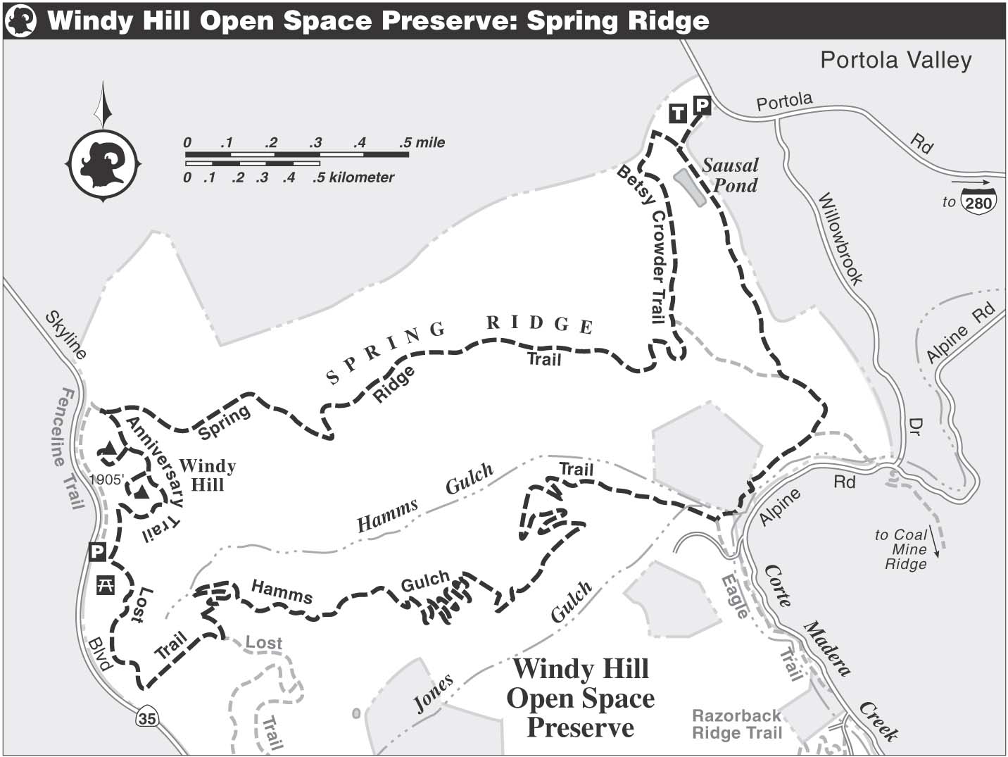
Follow a single-track trail uphill from the parking area to meet an equestrian trail joining sharply from the left. Turn right and go several hundred yards to a T-junction with a dirt road. The Spring Ridge Trail, a multi-use path, is left, but you turn right and almost immediately find the Betsy Crowder Trail on your left. As you start off on this trail, you pass a fence with a seasonal gate that prevents access by horses during wet weather.
The earthen dam that forms Sausal Pond is on your left, partially hidden behind a screen of trees and shrubs. Level at first, the trail now climbs gently to a T-junction with the Spring Ridge Trail, a dirt road. Here, you turn right and begin a curvy ascent through a good birding area — open fields alternating with groves of venerable coast live oaks. Spring Ridge is named for the many springs found nearby, which made the surrounding land valuable to early settlers and ranchers.
Notable Trails
- The Betsy Crowder Trail honors an MROSD board member who served from 1989 until her death in 2000. She was also active in the MROSD volunteer program, and was one of the authors of Peninsula Trails, published by Wilderness Press.
- The Anniversary Trail, built in 1987, commemorates MROSD’s 15th anniversary and also the 10th anniversary of Peninsula Open Space Trust, a local nonprofit land trust that provided major support for the acquisition of this preserve.
Passing a closed trail, left, at about 1 mile, you emerge from a wooded area and have a magnificent view uphill across rolling slopes to the twin summits of Windy Hill. The road, which may be muddy during wet weather, climbs steadily on grades that run the gamut from gentle to steep. Be sure to stop, turn around, and admire the scenic vista that extends across San Francisco Bay to the East Bay hills.
Windy Hill Foliage, Birds
- Valley oak, coast live oak, black oak, California buckeye, madrone, Monterey cypress, and eucalyptus are some of the trees growing beside the trail.
- Wildflowers here include California poppies, checkerbloom, lupine, yarrow, bellardia, and fiddleneck.
- You may be lucky enough to spot one or more of this preserve’s common raptors — red-tailed hawk, American kestrel, northern harrier, white-tailed kite — patrolling the skies or roosting in a tall Monterey cypress.
- Sausal Pond is home to wood ducks, and large wooden boxes have been placed on nearby trees to provide them with safe nesting sites. Green herons also live here, and sometimes their much larger cousins, great blue herons, drop by for a visit.
As you near Skyline Blvd., you may begin to feel the effects of the Peninsula’s coastal climate. The wind may increase, and great billows of fog may pour over the ridge. When you reach gate WH01 and an information board, both just east of Skyline Blvd., turn left. Just ahead is a fork, where you bear left on the hiking-only Anniversary Trail.
At around 3 miles you find a rest bench and an unsigned trail, right. To visit the preserve’s highest point, turn right and follow the short trail to Windy Hill’s north summit. From this impressive vantage point, you have 360-degree views of the San Francisco Bay Area and the San Mateo coast. After enjoying this beautiful spot, return to the Anniversary Trail and bear right.
Now follow the trail as it curves around the base of the north summit. At a saddle where two more rest benches await, you pass a trail to Windy Hill’s south summit, which is about 25 feet lower than its rival. These high vantage points and the hillsides just below them provide great birding opportunities. Spring sightings of lesser goldfinch and lazuli bunting here may encourage you to bring binoculars.

View from Windy Hill extends across Portola Valley and San Francisco Bay to Mt. Diablo.
The Anniversary Trail continues from the saddle by clinging to a narrow ledge cut in a hillside. Descending on a gentle grade, the trail makes a sharp bend to the left and brings you to a wood fence with a gap. Just beyond, the multi-use path joins sharply from the right. Now on level ground, you soon reach the end of the Anniversary Trail at its junction with the Lost Trail, which goes left. A parking/picnic area and a restroom are just ahead.
Here, you turn left on the Lost Trail, part of the Bay Area Ridge Trail, and after about 100 feet reach a seasonal gate that prevents access by horses in wet weather. Now the single-track trail climbs on a very gentle grade to a junction with the Hamms Gulch Trail. Turn sharply left and begin descending via switchbacks. Curving right, you pass an unofficial trail leading left to a promontory.
In a dense forest, you continue to descend a ridge by following the twists and turns of its gullies and ravines, some of which hold seasonal creeks. A rest bench, left, offers a great place to relax and enjoy a fine view of Windy Hill. Beyond, the trail continues to lose elevation on a grade that alternates between gentle and moderate, with Hamms Gulch steeply downhill and left. Soon you come to another seasonal equestrian gate. Just beyond the gate, at about 6.3 miles, you bear left on a connector to the Spring Ridge Trail.
Hamms Gulch, which holds a seasonal tributary of Corte Madera Creek, is a lush and lovely area, where Douglas-fir, bay, bigleaf maple, and madrone are joined by snowberry, honeysuckle, berry vines, and ferns. Cross the creek in Hamms Gulch on rocks, then climb gently beside Corte Madera Creek. A dense, riparian corridor borders Corte Madera Creek, but uphill and left is a savanna of mostly valley oaks, giving this part of the route a park-like feel. Many of the oaks are draped with strands of lace lichen, and some hold large clumps of mistletoe.
Continue straight through a four-way junction, now on a dirt road. The next junction, also four-way, is with the Spring Ridge Trail, and again you continue straight. A low-lying, marshy area holding the upper reaches of Sausal Creek is to your left. Sausal Pond, designated a “critical wildlife habitat,” is just ahead. Beyond the pond, close the loop and then turn right to the parking area.