TRIP 8 Los Trancos Open Space Preserve
| Distance | 2.3 miles, Loop | |
| Hiking Time | 1 to 2 hours | |
| Elevation Gain/Loss | ±500 feet | |
| Difficulty | Moderate | |
| Trail Use | Good for kids | |
| Best Times | All year | |
| Agency | MROSD | |
| Recommended Map | Los Trancos Open Space Preserve (MROSD) |
HIGHLIGHTS This route combines two scenic loops, the Franciscan Loop Trail and the Lost Creek Loop Trail, to explore a small, wedge-shaped preserve that is rich in geological and botanical interest. The San Andreas fault runs through the preserve. Oaks, bays, bigleaf maples, and Douglas-firs provide a protective canopy for an assortment of native shrubs and wildflowers. Along the way you will descend to the headwaters of Los Trancos Creek, which forms part of the border between San Mateo and Santa Clara counties. (To learn about the area’s geology, you can also visit the self-guiding San Andreas Fault Trail, which starts from the west side of the parking area.)
DIRECTIONS From I-280 in Los Altos Hills, take the Page Mill Road/Arastradero Road exit and go south on Page Mill Road 7.2 miles to a parking area, on your right. This parking area is just a few hundred feet past the parking area for Monte Bello Open Space Preserve, which is on the left.
From the intersection of Skyline Blvd. (Highway 35) and Page Mill Road south of Palo Alto, take Page Mill Road north 1.4 miles to a parking area on your left. (The parking area for Monte Bello Open Space Preserve is just a few hundred feet past this parking area, on the right.)
FACILITIES/TRAILHEAD There is a toilet in the Monte Bello Open Space Preserve parking area, just across Page Mill Road. There are no facilities at the trailhead, which is on the northeast corner of the parking area.
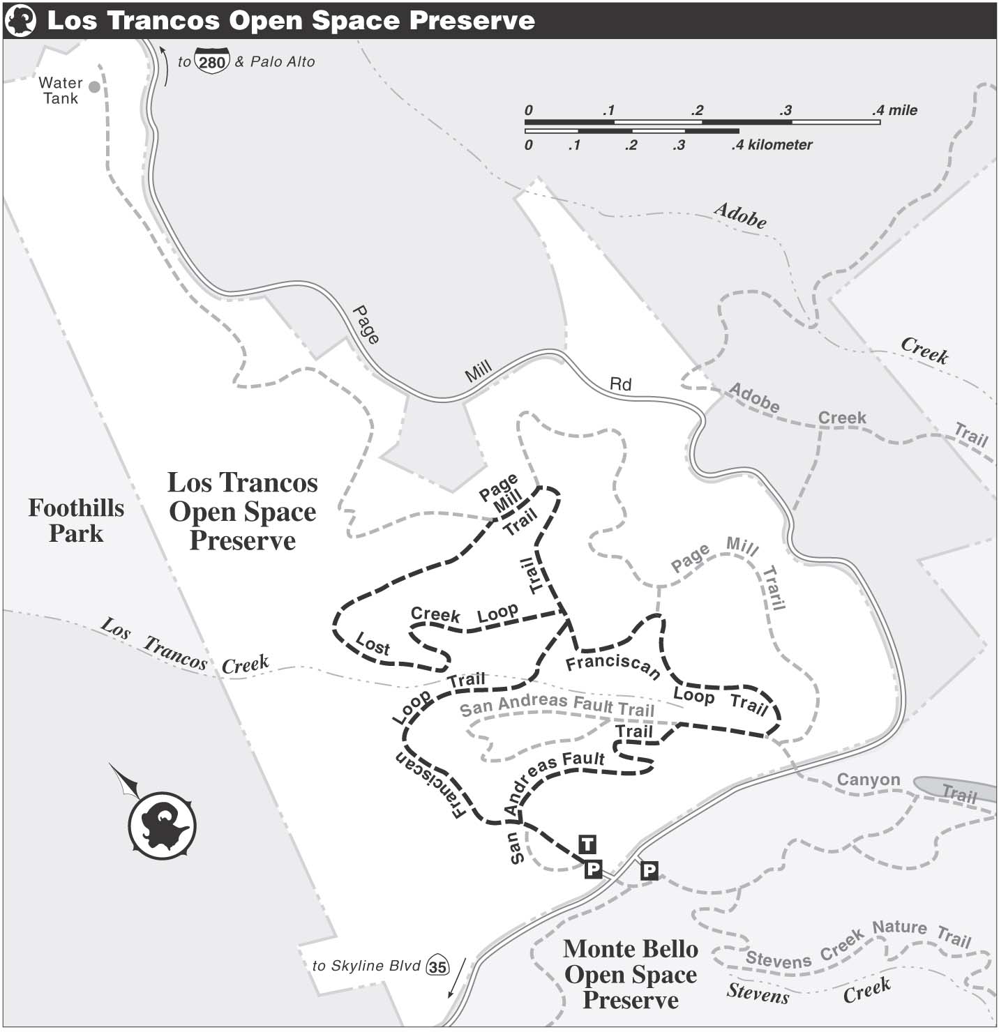
Head north on the Franciscan Loop Trail, and on a clear day you are immediately rewarded with a sweeping view that stretches up the Peninsula to San Francisco and takes in the hulking forms of San Bruno Mountain and Mt. Tamalpais. After about 75 feet the single-track trail forks. The right-hand branch, an unofficial trail, climbs a low rise, offers additional views, and then rejoins the Franciscan Loop Trail. Staying left, you cross a weedy field full of coyote brush, oats, and some thistle.
The depression near the trailhead, marked with white-striped posts to indicate minor fault breaks from the 1906 earthquake, is a sag pond. Sag ponds are found in fault zones and landslide areas where the land has sunk because of earth movement. These ponds often fill with water during winter and become freshwater marshes.
About 100 yards from the trailhead, the San Andreas Fault Trail merges from the left. At the next junction, where the Franciscan Loop Trail goes both left and straight, you bear left. The unofficial trail mentioned above joins sharply from the right. (The San Andreas Fault Trail, which for part of its length follows the Franciscan Loop Trail, is straight.)
Now you descend through a shady corridor, cross a bridge, and then follow the trail to a T-junction with the Lost Creek Loop Trail. Here, you turn left and after about 75 feet pass the returning end of the Lost Creek Loop Trail on your right. Continuing straight, you follow a gently rolling course and then work your way down a densely wooded ridge via switchbacks to the bank of Los Trancos Creek.
Stepping up to the Creek
In Spanish, tranco means stride or big step, and tranca is a bar or barrier. California Place Names favors a corruption of the latter to explain this creek’s name: Perhaps there were barriers here at one time to prevent cattle from crossing it, or perhaps the creek itself formed a natural barrier.

The San Andreas fault cuts through this preserve, which has a self-guiding nature trail.
Los Trancos Flora
- This preserve is a great place to study native trees, including canyon oak, valley oak, black oak, tanbark oak, madrone, California bay, bigleaf maple, and Douglas-fir.
- Hedge nettle, hound’s tongue, milkmaids, Solomon’s seal, starflower, bleeding hearts, and trillium are a few of the many forest wildflowers found here.
- A variety of shrubs also thrive in the preserve, including coffeeberry, hazelnut, snowberry, gooseberry, creambush, elk clover, and thimbleberry.
Walking downstream, you have the creek on your left. Soon, the trail finds a level course, but the creek cuts its way into an ever-deepening canyon. Now your route curves right and follows a tributary of Los Trancos Creek, which may be dry, upstream. Soon the Page Mill Trail merges from left and joins the Lost Creek Loop Trail for several hundred yards. You continue straight, and at the next junction stay on the Lost Creek Loop Trail by turning sharply right.
Now you ascend via switchbacks into a brighter realm, where a short boardwalk helps you through a marshy area. Reaching a T-junction where the two ends of the Lost Creek Loop Trail join, you turn left and retrace your route for about 75 feet. Here, at a junction with the Franciscan Loop Trail, you continue straight, then curve right and begin to climb. Where a connector to the Page Mill Trail goes left, you stay right.
Passing a very short trail to Page Mill Road, you meet the San Andreas Fault Trail at a T-junction. You turn left and immediately confront a fork. Angling left is a short trail to the San Andreas Fault Trail’s interpretive station 3. During the 1906 earthquake, the ground opened along the San Andreas fault. Later it filled in, forming the flat area, or bench, that is here now.
Bearing right at the fork to stay on the Franciscan Loop Trail, you climb via switchbacks between a line of trees, right, and open meadow, left. At the four-way junction where you began this loop, simply continue straight and retrace your route to the parking area.