8 Brookbank Trail
This short hike heads up a historic wagon road in the Dry Lake Hills. The hike ends at a seasonal lake and meadow, which is surrounded by a fine mixed forest of aspen, pine, and fir. Close-up views of the San Francisco Peaks are a special bonus.
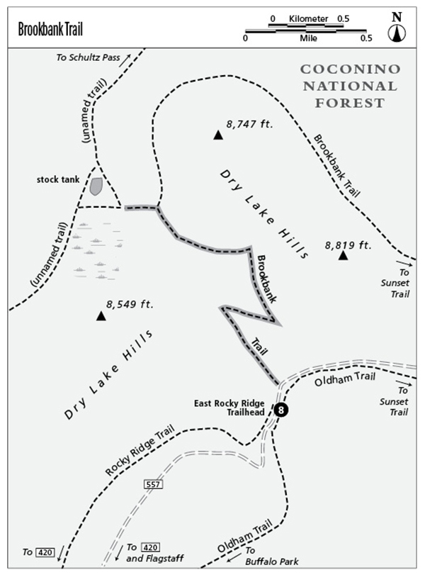
Location: 6 miles northwest of Flagstaff.
Distance: 2.2 miles out and back.
Approximate hiking time: 2 hours.
Elevation change: 630 feet.
Best seasons: Summer through fall.
Water: None.
Other trail users: Horses and mountain bikes.
Canine compatibility: Dogs are allowed if kept under control.
Permits and restrictions: None.
Maps: USGS Sunset Crater West and Humphreys Peak; Coconino National Forest. The trail is not on the topo map.
Trail contacts: Peaks Ranger District, Coconino National Forest, 5075 N. Highway 89, Flagstaff, AZ 86004, (928) 526-0866, www.fs.fed.us/r3/coconino/.
Finding the trailhead: From Flagstaff, drive 3 miles north on U.S. Highway 180. Turn right (north) on Schultz Pass Road (Forest Road 420). Drive 0.5 mile, then go straight (north) onto the Elden Mountain Road (Forest Road 557), which is a maintained dirt road. Continue past a few houses and through a gate (this gate is closed in winter and spring when the road is muddy). The road becomes rougher but is passable to most vehicles if driven with care. Park at the East Rocky Ridge Trailhead on the right (northeast); the trailhead is 3 miles from the Schultz Pass Road.
The Hike
The Dry Lake Hills get their name from several meadows that lie on the summit plateau. Early in the season, after the snow melts, the meadows become seasonal lakes. As the lakes dry up, the meadows in turn become a riot of wildflowers.
The meadow at the end of this hike is on private land. Although there are no restrictions on hiking at present, this could change in the future. Always respect private property and obey all signs, if posted.
Walk a few dozen yards north up Elden Mountain Road to the signed Brookbank Trail. Turn left (northwest) on the trail, which follows an old wagon road up an unnamed canyon, then climbs south-facing slopes via several switchbacks. The old road apparently was built by an early settler to reach the meadows that grace the top of the Dry Lake Hills.
After a moderate but sustained climb through mixed ponderosa pine, Douglas fir, aspen, and Gambel oak forest, with an occasional view to the south, the trail reaches a junction. The Brookbank Trail goes right (north), but this route continues straight ahead on the unnamed trail. You will reach a broad, open meadow at 1.1 mile. The graceful summit of Agassiz Peak, the second highest summit of the San Francisco Peaks at 12,356 feet, looms above the meadow.
Miles and Directions
0.0Trailhead.
1.0Stay left on an unnamed trail where the signed Brookbank Trail goes right.
1.1Reach the dry lake and meadow.
2.2Arrive back at the trailhead.