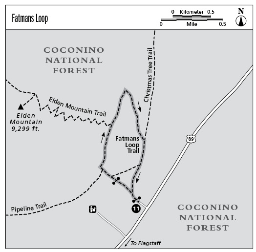
11 Fatmans Loop
This scenic hike travels through rugged terrain on the east slopes of Elden Mountain. This loop trail is accessible via paved roads and, because of its southeast exposure, dries out earlier than other trails at the same elevation.
Location: Northeast Flagstaff.
Distance: 2.2-mile loop.
Approximate hiking time: 2 hours.
Elevation change: 540 feet.
Best seasons: Spring through fall.
Water: None.
Other trail users: Horses and mountain bikes.
Canine compatibility: Dogs must be leashed.
Permits and restrictions: None.
Maps: USGS Flagstaff East; Coconino National Forest.
Trail contacts: Peaks Ranger District, Coconino National Forest, 5075 N. Highway 89, Flagstaff, AZ 86004, (928) 526-0866, www.fs.fed.us/r3/coconino/.
Finding the trailhead: From the junction of Interstate 40 and U.S. Highway 89 in east Flagstaff, drive north on US 89 about 0.6 miles, then turn left (west) into the Elden Mountain Trailhead parking area. This trailhead is just north of the Peaks Ranger Station.
The Hike
This trail traverses some rugged volcanic terrain with good views. From the trailhead, follow the trail past the information sign and through a gate. Turn left (northwest) at the first signed junction at 0.2 mile; this is the start of the Fatmans Loop. You will return on the trail that forks to the right. The trail climbs northwest toward the imposing east face of Elden Mountain. It passes through another gate where an unsigned trail joins from the right. At 0.4 mile, you’ll pass the Pipeline Trail, which goes left (southwest). Continue on the Fatmans Loop as it turns north and climbs the lower slopes of the mountain through Gambel oak and ponderosa pine forest.
At the high point of the loop, the Elden Mountain Trail goes left (west) at 0.8 mile. Stay right on the Fatmans Loop as it continues north, then abruptly turns southeast and starts to descend, winding through huge volcanic boulders.
As it comes out onto the lower, gentler slopes, the trail meets the Christmas Tree Trail, which joins on the left (northeast) at 1.6 miles. Continue to the right (south) to the Fatmans Loop junction at 2 miles, then turn left (southeast) to return to the trailhead.

Mils and Directions
0.0Elden Mountain Trailhead.
0.2Turn left (northwest) at the start of Fatmans Loop.
0.4At the Pipeline Trail, stay right (north).
0.8At the junction with the Elden Mountain Trail, stay right (north).
1.6At the Christmas Tree Trail crossing, stay right again.
2.0Reach the end of Fatmans Loop and turn left (south).
2.2Arrive at the Elden Mountain Trailhead.