DRIVING TOUR # 3
Cedar Creek and Belle Grove
National Historical Park Visitor Contact Station
7710 Main Street, Middletown, VA 22645
GPS coordinates: 39.03118° N, 78.27557° W
At the visitor contact station, pick up maps, brochures, and information about the battle of Cedar Creek. Tours are offered seasonally, so you can inquire about them if you have the opportunity. Exhibits and an illuminated battle map highlight the battle of Cedar Creek coupled with displays about the history of the Shenandoah Valley and the Civil War in the region.

![]() TO TOUR STOP 1
TO TOUR STOP 1
Turn left out of the contact station parking lot and proceed 1.5 miles south. Cedar Creek Battlefield Association Headquarters will be on your left.
GPS coordinates: 39.01604° N, 78.29623° W
Stop 1: Cedar Creek Battlefield Association Headquarters
8437 Valley Pike Middletown, VA 22645
Situated on the vital Valley Pike (present day VA Route 11), the stop here is directly across from the fields around Belle Grove. The Union army’s sprawling encampment was spread through this area.
Prior to the formation of Cedar Creek and Belle Grove National Historical Park and the opening of the National Park Service visitor contact station, the Cedar Creek Battlefield Association was the organization that worked to preserve the battlefield. They have continued in operation and still have their headquarters with a small bookstore and information here at this location. One of the later stops on the driving tour will be at the entrenchments of the Union XIX Corps. To hike these entrenchments, please get permission at this stop.

![]() TO TOUR STOP 2
TO TOUR STOP 2
Turn left out of the association’s parking lot. Proceed one mile south on the Valley Pike and make the left on Water Plant Road. Proceed one mile to the intersection with Long Meadow Road (note: at the intersection, Water Plant Road will change names to Gafia Lodge Road). Turn right onto Long Meadow Road. In approximately .01 mile, turn right onto Bowman’s Mill Road. Proceed 1.4 miles down Bowman’s Mill Road. The road has several sharp elbow turns; the stop will be after a sharp bend in the road to the left. Signage will state “No Trespassing” and “Shenandoah Valley Battlefield Foundation.” There is a Civil War Trails sign at the stop. Pull over to the right of the road where a little pull-off is located. Permission can be attained ahead of time to access this property; otherwise please do not wander into the fields.
GPS coordinates: 38.99884° N, 78.31960° W
Stop 2: Camps of the Army of West Virginia
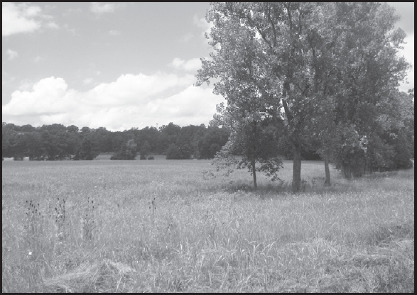
You are now at the extreme left of the Union line, which was manned by Maj. Gen. George Crook’s Army of West Virginia. Confederates under Maj. Gen. John Gordon’s command crossed from beyond Crook’s left, turning their position and striking the exposed left flank. The division of Maj. Gen. Joseph Kershaw came up the road to assault the Federals. With the first attacks happening as dawn arrived and heavy fog blanketed the area, these attacks surprised and then routed the Union defenders. Imagine, as a Union soldier, you are about to rise to breakfast, thinking the enemy is miles away, when thousands of Confederates, screaming the blood-stopping “Rebel Yell” descend on your encampments. What would your reaction be?

![]() TO TOUR STOP 3
TO TOUR STOP 3
Continue in same direction on Bowman’s Mill Road and, in 0.6 miles, stay to the right to continue on Bowman’s Mill Road. In front of you as you come down the hill will be Cedar Creek and the general area where the Confederates crossed.
GPS coordinates: 38.99107° N, 78.32801° W
Stop 3: Bowman’s Mill Ford
On the morning of October 19, 1864, approximately 2,500 soldiers of Joseph Kershaw’s division crossed here. The Southerners quickly overran the 5th New York Heavy Artillery guarding the ford and deployed for battle in the field around you. When Kershaw’s men came on line, they advanced toward Tour Stop 3.

![]() TO TOUR STOP 4
TO TOUR STOP 4
Proceed back up the hill and make the right onto Long Meadow Road. To your right is Cedar Creek and 1.2 miles down the road Cedar Creek will merge with the North Fork of the Shenandoah River. Continue on for another 0.2 miles and immediately following the driveway of Long Meadow farm—which is privately owned and not open to the public—pull your vehicle to the right side of the road.
GPS coordinates: 38.98487° N, 78.30330° W
Stop 4: Long Meadow
In this general area stood a log cabin, built by Jost Hite and later occupied by his son Isaac. This family could claim to be some of the first settlers in the lower Shenandoah Valley. The majority of the Confederate attacking force, consisting of Gordon’s flanking column, crossed here. Gordon’s old division, under Clement Evans, crossed first followed by Stephen Ramseur. John Pegram followed Ramseur. The men continued to march in column as they headed northwest before deploying for the assault. Shortly after 5:00 a.m. Gordon launched these three divisions—two in the front line, Evans and Ramseur, with Pegram in support—at Rutherford Hayes’ division. The men who advanced here were some of the best combat troops the Confederacy could muster by the autumn of 1864. If victory could be achieved, these would be the men to accomplish it. Follow their march and attack as you head to the next tour stop.
![]() TO TOUR STOP 5
TO TOUR STOP 5
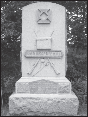
Continue on Long Meadow Road approximately 0.9 miles. At the intersection, turn left onto Water Plant Road. When that road comes up to the intersection of the Valley Pike, turn right to head north. Before turning, the 128th New York Monument may be visible to you across the road depending on the time of year of your visit. Note, you will be on the Valley Pike for less than a 10th of a mile and will be making a left onto a gravel road.
GPS coordinates: 39.008832° N, 78.309893°W
Stop 5: 128th New York Monument
Hailing from the Empire State, the 128th New York drew the assignment of holding the left flank of the XIX Corps. Surging Confederates, fresh off of wrecking Crook, approached the New Yorkers and lapped around to the rear. On top of this, a second Confederate force, Kershaw’s division, was moving in for an attack on their front. What did the 128th New York do? They hugged their entrenchments, loaded their rifles and made a determined stand. Losing their brigade commander, Col. Daniel McCauley, they hung on for the better part of an hour before being overrun and like other retreating bluecoats headed toward Belle Grove, your next stop.
![]() TO TOUR STOP 6
TO TOUR STOP 6
Turn left onto the Valley Pike and head north. In approximately 0.7 miles, turn left onto Belle Grove Road.
GPS coordinates: 39.02068° N, 78.30399° W
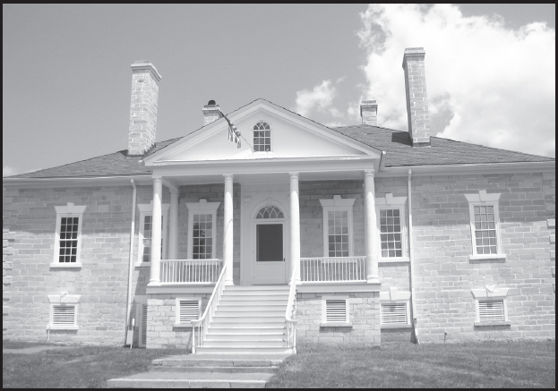
Stop 6: Belle Grove
336 Belle Grove Rd, Middletown, VA 22645
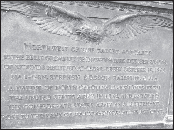
As you turn onto Belle Grove Road, to your immediate right will be the monument dedicated to Stephen Dodson Ramseur. Erected in 1919 by the North Carolina Historical Commission and The North Carolina Division United Daughters of the Confederacy, the monument reads, in part, that it stands 800 yards from where Ramseur died on October 20. One notable person in attendance when the monument was dedicated was Mary Dodson Ramseur, the daughter the late general never met. Be careful if you stop as the monument sits in close proximity to the Valley Pike.
Continue down the road and Belle Grove will come into your view off to your left front. Follow signs to the parking area. To inquire about tours of Belle Grove and other programs being offered, head toward the gift shop.
Belle Grove, built in 1797, stood as the plantation home of Isaac Hite, Jr., a grandson of the Hites from the log cabin history at Long Meadow. Isaac married into the family of President James Madison.
Prior to the battle, Belle Grove served as Philip Sheridan’s headquarters. At the beginning of the battle, Sheridan was still returning from a conference in Washington and had only made it as far as Winchester the night before. Union soldiers, pushed back from their first lines of defense, made a stubborn resistance here before Confederates were able to push the bluecoats from the fields and hillocks surrounding the plantation manor.

After the battle, Belle Grove transformed from a scene of killing to a scene of healing as scores of wounded were gathered from around the grounds and manor house. One of the Confederates brought to the main floor was the mortally wounded Stephen Dodson Ramseur. After Ramseur died, his body was taken to his hometown of Lincolnton, North Carolina, for burial. Ramseur was the second division commander of Early’s army to die during the campaign; the first was Maj. Gen. Robert Rodes, who was killed at Third Winchester.
![]() TO TOUR STOP 7
TO TOUR STOP 7
Turn right out of the parking lot at Belle Grove and proceed less than 0.1 miles. Turn right onto Meadows Mill Road and follow this road for 0.8 miles. Take the left onto Veterans Road and continue on for 0.25 miles. The high ground you are traversing was held by the VI Corps divisions of J. Warren Keifer and Frank Wheaton. Here, they engaged Kershaw’s and Evans’ attacking Confederations. Make a right onto State Route 635, and the cemetery is located 0.3 miles down this road.
GPS coordinates: 39.03197° N, 78.28645° W
Stop 7: Mount Carmel Cemetery
When visiting the cemetery, it is encouraged by the cemetery’s management to park in the gravel parking area outside the confines of the cemetery and walk in. Proceed to near the white cinderblock building to get a feel for the grounds. Please be respectful of the cemetery as it is still active, and there could be a funeral procession that would close the area to the public.
Around the headstones, Union soldiers made a determined stand for 90 minutes. Fitting of his name, Brig. Gen. George Washington Getty’s division slowed the Confederate avalanche coming towards them. Getty deployed his men as Keifer and Wheaton attempted to hold back the enemy advance. From right to left, Getty placed the brigades of James Warner, Lewis Grant, and Daniel Bidwell. Here, Getty repulsed assaults by John Pegram’s division, elements of the 43rd, 45th, and 53rd North Carolina infantry, and 2nd North Carolina Battalion of Bryan Grimes’ brigade and Gabriel Wharton’s division. While repelling Grimes’ Tarheels, Daniel Bidwell was mortally wounded. He died later that evening. After repulsing these attacks and weathering a 30-minute bombardment from artillery, the Federals pulled back. The defense was crucial to arresting the momentum of the Confederate offensive that morning.


Brig. Gen. Daniel Bidwell (LOC)
![]() TO TOUR STOP 8
TO TOUR STOP 8
Proceed .03 miles down High Street. Turn right onto Chapel Road but take a quick left in approximately 0.1 miles onto Mineral Street. Travel down Mineral Street for a half-mile to Miller’s Mill. Park the car just past the intersection of Mineral Street and Cougill Road, but since Miller’s Mill is privately owned, it is best to stay in your car.
GPS coordinates: 39.03884° N, 78.27319° W
Stop 8: Miller’s Mill
You are looking at the high-water mark of the Confederate advance at Cedar Creek. Early organized his line here along Miller Lane (present day Cougill Road), and as he did so, soldiers began to leave the line and return to the captured Union encampments. In search of supplies, other impedimenta of war, and more importantly food, their wanderings depleted the strength of the Confederate line. Many of Early’s men had not eaten that morning and barely had anything of substance for quite a while—basic needs prevailed. A sense that the day was already won might have convinced others to leave ranks to satisfy growling stomachs. The knoll to your left is also where Stephen Ramseur was mortally wounded during the Federal counterattack later that afternoon.
![]() TO TOUR STOP 9
TO TOUR STOP 9
Continue down Cougill Road and continue on for 0.8 miles. Turn right onto Hite Road and proceed 0.9 miles. Take the right onto Klines Mill Road and the stop will be 0.9 miles down. The small waterway you pass over, Meadow’s Brook, is the site where Sheridan came upon his army, after his ride from Winchester. After crossing the bridge, you can park your car on the right side in the gravel area. As there is not much space here, it may be best to stay in your vehicle.
GPS coordinates: 39.05297° N, 78.26291° W
Stop 9: Sheridan’s Arrival
It was here that the most famous aspect of the battle of Cedar Creek occurred. Phil Sheridan returned to the Shenandoah Valley the night before following a council of war in Washington. Seeing no reason to push on the final 15 miles, he spent the night in Winchester. The following morning Sheridan was alerted by sounds of gunfire and artillery to the south. Mounting his horse, Rienzi, he began what is now known as “Sheridan’s Ride,” reaching the location you are now at around 10:30 a.m. Sheridan’s appearance uplifted the men’s spirits. Captain William McKinley, the future U.S. president, then serving on George Crook’s staff, recommended that Sheridan ride down the length of his line so his men could see him. The response from his men stirred their broken spirits. Preparations were made for a counterattack. The Union army had already weathered the worst of the Confederate offensive by the time Sheridan arrived. However, the importance of his presence on the morale of his soldiers cannot be overlooked.

![]() TO TOUR STOP 10
TO TOUR STOP 10
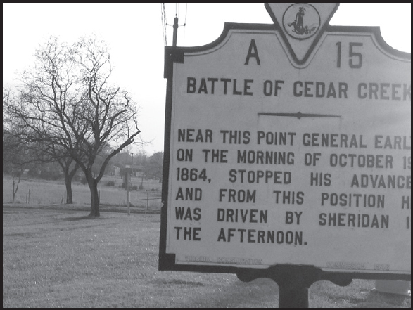
Continue on Klines Mill Road approximately 0.5 miles, and when you reach the Valley Pike turn right. In 1.4 miles, turn left onto Skirmisher Lane, the third of the entrances to Lord Fairfax Community College. There is a historical marker located at the western end of the parking lot near the Valley Pike titled “Battle of Cedar Creek.” Parking close to the southern end of the community college is encouraged as that will put you in the best location in reference to the Union counterattack. One item to note: being a community college, the parking lots fill quickly on school days.
GPS coordinates: 39.03544° N, 78.26857° W
Stop 10: Union Counterattack
173 Skirmisher Lane, Middletown, VA 22645
If you look off to your right (if one is facing south), the Miller house is visible in the distance. This area marks where the Confederate line ran through in the early afternoon of October 19. Around 4 p.m., Sheridan ordered a counterattack, and Union soldiers advanced into the fields around you and struck the Confederate line. Though outnumbered, the Confederates put up a stiff resistance. Overwhelming numbers and Union cavalry attacking the line’s left flank caused the line to cave in. The Confederates disintegrated from the west to the east. Victory, within the grasp of the Southerners, turned into a disastrous defeat as Early’s army raced to safety. The Union secured their grasp on the lower Shenandoah Valley.
Somewhere in this general area, Col. Charles Russell Lowell was mortally wounded (see page 79).
This concludes the driving tour for Cedar Creek.
