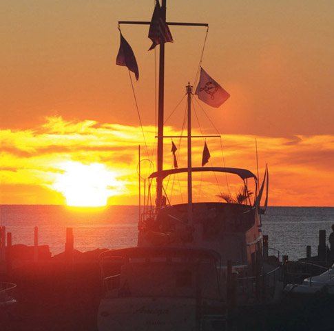
“Lake Winnebago, from which this county derives its name, is twenty-eight miles long, and ten miles wide, in its greatest dimensions, and covers an area of about two hundred and twelve square miles. The Neenah [Fox] river enters it near the middle, and leaves it at the northwest angle, by two channels, enclosing Doty’s island, by which it is connected with the Little Butte des Morts lake. These channels are known as the Winnebago rapids. ‘The water,’ says Capt. Cram, ‘is hard, and when not violently agitated, is quite pellucid, but becomes turbid during long and severe blows and has a depth sufficient for the purposes of navigation.’ ”
From Geographical and Topographical Description of Wisconsin by Increase Lapham, 1844
This eastern Wisconsin inland lake borders Appleton and Neenah-Menasha on the north and has Oshkosh midway on its western side and Fond du Lac at its southern tip. Lake Winnebago is part of the Wolf and Fox River systems; the Upper Fox enters Winnebago through Lake Butte des Morts near Oshkosh and exits at Neenah-Menasha, where the Lower Fox continues northward on its way to the southern end of Green Bay.
The name Winnebago is derived from a name for the Native American people who settled this area and who call themselves the Hochungra, or Ho-Chunk. Winnebago is the largest interior lake in Wisconsin, covering 215 square miles with 85 miles of shoreline. Roughly thirty miles long and varying from five to ten miles wide, Winnebago has a maximum depth of only twenty-one feet. Despite this shallowness, the lake can be dangerous in bad weather.
Lake Winnebago and connecting rivers have been a valuable resource to this part of Wisconsin for hundreds of years. In the seventeenth century, Joliet and Marquette traveled these water highways, which soon became part of the commercial route between French Canada and the Gulf of Mexico. Grinding mills utilized the waters of the “Big Lake” to turn waterwheels that powered the grinding machinery. Settlers relied on the lake water for cooking, bathing, laundry, and even extinguishing fires. Later, the transport of lumber became a principal activity on Winnebago, lasting through the 1800s. Winnebago ice was also an important winter commodity. And recreational boating has been a mainstay for tourists and locals for decades. The lake is popular today for its sport fishing, including sturgeon spearing and ice fishing.
Parts of the Fox River system are a workhorse waterway, with many industries and commercial docks along its route. The navigation season on Lake Winnebago runs from approximately the beginning of May through October. The four lighthouses (and two metal light towers, Calumet Harbor and Fisherman’s Road) here are some of the newest in the state.
In the mid-1850s, a massive lighthouse was located at the head of the Menasha channel on the very northern limits of Lake Winnebago. It had a relatively short life, however, and was reduced to ruins by 1880. An envisioned waterway linking the Fox and Wisconsin Rivers never materialized at that time, so the light was not considered to be cost effective. The abandoned light became a gathering place for skating parties and a shelter for fishermen until a fire gutted it in 1879. Nautical charts of today still feature Lighthouse Reef on the northernmost end of Lake Winnebago. Water depths of only two to three feet are common a half-mile off the Neenah-Menasha shoreline.
A quiet, scenic waterfront park, Kimberly Point Park in Neenah on Lake Winnebago’s northwestern edge is home to one of four present-day Lake Winnebago lighthouses. Approximately 150 feet west of this point of land once stood an aged elm tree known as the Old Council Tree, where Native Americans and European settlers rendezvoused and held council. The tree was cut down around 1890 when the river was made wider and deeper.
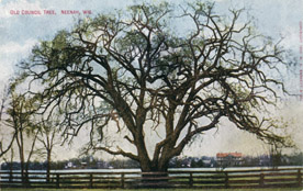
The Old Council Tree at Neenah
WHI IMAGE ID 41695
The Neenah Lighthouse might never have been built in Kimberly Point Park if not for the forward thinking of Helen Kimberly Stuart. Stuart donated the land to Neenah’s park system in 1929 as her gift to the community. Clearly a trailblazer, she was the first woman elected to the Neenah board of education; the first woman to serve on Neenah’s city council, plans commission, and library board; and the first woman to run for mayor of Neenah. She founded the Neenah League of Women Voters, was president of Wisconsin’s League of Women Voters, and was appointed to the University of Wisconsin Board of Regents. Stuart successfully battled the Kimberly-Clark Company, the largest paper company in town, when its president, F. J. Sensenbrenner, planned to buy all the land forming the Point and build a million-dollar estate there. No one worked with as much energy as Helen Kimberly Stuart to preserve Park Point and the road allowing access to it, Lake Shore Drive. Sensenbrenner did eventually build his home—on the opposite side of Lake Winnebago. The land remained public, and Stuart donated four additional parcels to expand the park. She funded its maintenance for many years to come and financed the planting of elm and flowering crabapple trees there, some of which survive to this day. The park is named for Helen Kimberly Stuart’s father, John Alfred Kimberly, one of the founders of the Kimberly-Clark Corporation.
Discussions about erecting a lighthouse at the confluence of the Fox River and Lake Winnebago began in 1939. The Flour Brothers Construction Company of Oshkosh completed construction in 1945. The lighthouse is named for James Cheney Kimberly, Helen Kimberly Stuart’s brother, who donated the money for the lighthouse in 1944.
The tower is constructed of brick, block, and wood. The upper tower features several windows and a framed steel-and-glass top portion that houses the beacon. The lighthouse’s elevation was increased nearly ten feet in 1954 to make the light more visible. Total height of the structure is thirty-nine and a half feet. Twin porches on each side of the base form a patio.
Neenah Lighthouse welcomes boaters traveling to and from Lake Winnebago via the Fox River. The light is controlled automatically by a timer and is operational during the navigational season, which runs from roughly early May through October. It is considered an official navigational aid. The upper portion housing the light is not open to the public, and no tours are given. Handicapped-accessible restrooms are available, and a handicapped-accessible fishing deck, added in 1991, increases the usefulness of the light and park for everyone. Playground equipment and picnic facilities are also found here.
CURRENT STATUS: Active aid to navigation. Because of its significance to the history of Neenah’s water recreation, the lighthouse is listed on Wisconsin’s State Register of Historic Places. It is also on the National Register of Historic Places.
HOW TO GET THERE: Located on Lakeshore Avenue at the end of Wisconsin Avenue in Kimberly Point Park. From the north, take US 41 and exit at Highway 114 (Winneconne Avenue). Stay on Highway 114 for 1.2 miles until you reach Commercial Street. Turn left onto Commercial Street and proceed 0.3 mile to Wisconsin Avenue. Turn right onto Wisconsin Avenue and go 0.9 mile to Lakeshore Avenue. Turn left onto Lakeshore, go 0.5 mile, and you will see the sign for Kimberly Point Park.
Several miles north of Oshkosh on Lake Winnebago’s western coast, the old Asylum Bay Lighthouse stands idle, a lonely sentinel in a once busy area known as Asylum Point that separates North and South Asylum Bays. (This area’s name stems from the mental health facility that has existed here since the 1870s.) The Wisconsin Conservation Commission (WCC) and federal Works Projects Administration (WPA) also were involved with the development of this area in the 1930s and 1940s. Constructed in 1937, the lighthouse stood guard on an artificial island once known as Lighthouse Island and Picnic Point. The main tower stands twenty-four feet high and has a circumference of eight feet at the base, tapering to six feet near the top. Several rectangular windows adorn the brick tower, and a large door sits at the base. The structure is topped with a seven-foot-tall cupola. Years ago a flagpole crowned the structure, bringing its total height to forty-two feet. Today, a weather-vane accents the tower.
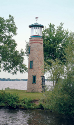
Asylum Bay Lighthouse
The island was originally mainly marshland, which when filled in measured about six hundred feet long and seventy-five feet wide. With several open-air fireplaces and plentiful trees, shrubs, and flowers, the island was a popular spot for picnickers. A wooden bridge connected Lighthouse Island to the mainland.
A fishpond was created by the dredging of a channel, and a rough fish removal program for Lake Winnebago was centered here. Anglers harvested carp and sheeps-head and sold them to markets in Chicago and New York. The rough fish harvest averaged a million pounds annually. The Asylum Bay Lighthouse marked the fishing operation’s headquarters, guiding fishermen as they returned to shore at night. It also marked a potential refuge for any boats caught on Lake Winnebago in stormy weather. The headquarters was a hub of activity, serving as the site for boat building, barge traffic, and fish-trapping equipment. When this entire area was being developed, a significant Native American burial ground was discovered.
The light at Asylum Bay was never electrified. Instead it was lit with a kerosene lantern whose flashing beacon ranged a dozen miles in good weather. Very little other history is available regarding this lighthouse. It is unknown when this light ceased operation.
CURRENT STATUS: Inactive. In 2007, the lighthouse underwent a $4,000 restoration under the direction of the Winnebago County Parks Department. Repairs were made to the brickwork, the roof was replaced, and the windows were refitted. A fish weathervane was placed atop the tower. Windows replaced weathered boards in the lantern. A new footbridge from the mainland to the island has been added, making it easy to access the island for close-up views of the lighthouse. This site is a favorite spot for anglers.
HOW TO GET THERE: From the north, take US Highway 41 south to Snell Road. Turn left onto Snell Road. You will cross County A, then go 0.3 mile to Sherman Road. At this point Sherman Road goes only to the left or right, and you will see a Wisconsin Department of Natural Resources Headquarters sign at Sherman Road. Turn right onto Sherman. Follow Sherman approximately 0.8 mile past the Asylum Bay Boat Launch. Follow the winding road to Asylum Point and a small parking lot.
Settled in 1836 at the mouth of the Fox River, at the site of a former French trading post, the city of Oshkosh was named in honor of a Menominee chief. The waterways around Oshkosh played a vital role in its development and history. Early on, a trading post and sawmill were established here. Today many recreational opportunities await Oshkosh citizens and tourists.
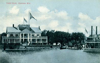
Oshkosh’s yacht club around the turn of the twentieth century
WHI IMAGE ID 43475
Located on Winnebago’s western shore where the Fox River empties into the lake, Rockwell Lighthouse has been an Oshkosh landmark for more than a century. One old account says the light, built in 1909, was used to mark nearby reefs. Much of Lake Winnebago in the vicinity of the lighthouse is shallow.
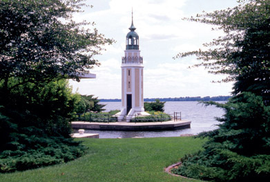
Rockwell Lighthouse
George Andrews Rockwell, an architect and native of Oshkosh, drew up plans for the light in 1909 shortly before his death at age forty-one. Rockwell’s friend William Bray, a former Wisconsin state senator, had acquired parcels of land in 1907 and 1908 that included the fairly isolated point. It was reported that rainstorms made the roads virtually impassable there. Records show that Bray tried but failed to convince the government to erect a lighthouse on the point, so he built the light with his own funds after the blueprints were discovered following Rockwell’s death. Bray assumed the cost of upkeep and the responsibility of keeping the light lit, and Bray’s Lighthouse became a part of Bray’s private harbor improvements for his own pleasure boats. He transformed the entire point into a showplace where he entertained friends and colleagues. President William Howard Taft once visited here.
The lighthouse also served as a signal for shipping on the Fox River and Lake Winnebago during the years when commercial navigation was important in this area. The beacon was considered a government-licensed light after 1917, when commercial traffic became substantial. The government then realized the importance of the light and paid its expenses for a time. Early airplanes may also have used this light as a guiding beacon before pilot guidance systems became more accurate.
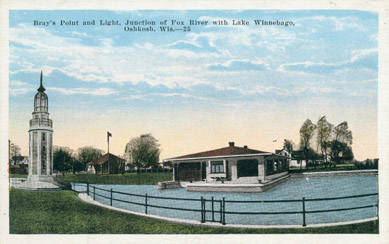
A postcard depiction of Rockwell Lighthouse at Bray’s Point
WHI IMAGE ID 97094
The lighthouse and surrounding property and point have changed ownership many times. Each new owner was responsible for paying taxes on this private property, and the name of both the lighthouse and the point changed along with the owners, including Bray (1909), Thompson (1918), and Buckstaff (1940s). Even today, the lighthouse is often called Bray’s or Buckstaff’s Lighthouse.
With its eight-sided shape, white-and-cream-colored stucco walls, and delicate black ironwork, Rockwell Lighthouse is one of the most ornate of all Wisconsin lights. Windows line the tower, and a short staircase leads to a doorway at the light’s base. Its total height is approximately forty-two feet. During the late 1950s the light was no longer lit, and the tower fell into disrepair for a number of years. In the mid-1980s the street and area immediately surrounding the light were renovated to allow the property owners more privacy and to protect the light from vandals. The light was restored and relit in the summer of 1986 by the owners of the property. A parklike setting now gives this historic beacon more security. The lighthouse sits on a miniature concrete-and-grass island, and a copper plaque at the base of the light reads: Rockwell Light, George Andrews Rockwell, architect, 1909.
CURRENT STATUS: This privately owned and operated light is in a residential area. The light can be seen from the street, but trees block part of the view. Rockwell Lighthouse continues to show the way for recreational users of Lake Winnebago, who are guided by its fixed red light. The beacon operates year-round and is controlled by a photo sensor that automatically turns the light on, day or night, when the sky darkens. The owners are listed with the US Coast Guard as the official lighthouse keepers.
HOW TO GET THERE: From the north or south, take Main Street (Highway 45) through downtown Oshkosh. Turn east onto Merritt Avenue. Drive 0.4 mile to Bowen Street; turn right (south) on Bowen. Go 0.6 mile to Bay Shore Drive and turn left. Proceed on Bay Shore 0.5 mile until the road makes a sharp left turn just before a home with a large stone wall in front of it. The lighthouse will be on your right. This light is on private property; please be respectful.
IN 1917 THOMPSON’S POINT LIGHTHOUSE (also known as Rockwell Lighthouse) was the only government-licensed inland light. When the federal government decreed the light must be lit without interruption, Mrs. Thompson (first name unknown) was appointed keeper. She held a keeper’s license for the lighthouse for many years.
The name Fond du Lac, appropriately, means “end of the lake.” Seated at the foot of Lake Winnebago, Fond du Lac was the site of an early 1800s French trading post. Later it was nearly named the capital of the new state of Wisconsin. Fond du Lac County is home to rich farmland and stone quarries.
This decorative eight-sided light tower is a picturesque landmark familiar to Fond du Lac residents, who know it as Lakeside Park Lighthouse. Visitors to the scenic park also know it as a welcoming beacon. Situated at the entrance to the Fond du Lac harbor, marina, and yacht club at the southernmost end of Lake Winnebago, the lighthouse shares duties with buoys that mark the channel. The structure replaced an ordinary red light that previously marked the harbor entrance.
The lighthouse, the brainchild of Fond du Lac lumberman W. J. Nuss, was built entirely with donated building materials and private funds from Nuss and others. The cornerstone was laid on July 10, 1933, with much pomp and circumstance. The white Cape Cod-style wooden tower stands approximately fifty-six feet tall and measures twelve feet in diameter. The base is composed of stone. The money used to purchase a light to top the tower was raised by the local yacht club, which conducted excursions on Lake Winnebago at the time. A stairway allows the public to climb to the open walkway atop the tower to an observation platform forty-four feet above the ground. A gorgeous panoramic view of Lake Winnebago and the nearby harbor is the reward for the seventy-two-step climb.
During windy conditions the tower could be felt swaying, and in the early 1960s the tower was deemed unsafe and was closed to the public. Later in that decade the local Optimist Club and the city of Fond du Lac appropriated funds to rebrace the interior of the tower and replace the stairs, floors, and roof. The interior walls, which displayed years of graffiti, were left intact, while the outside received a new coat of white paint. A celebration on July 3, 1968, commemorated the newly renovated tower. Mounted on a boulder on the lighthouse grounds is a plaque that reads: Saved 1967, Restored 1993. Fond du Lac Evening Optimist Club.
Today boaters use the red light atop the white tower by lining it up with a light behind the boathouses, similar to a range light system. The grounds surrounding the lighthouse are neatly landscaped and boast many colorful plantings. Tours are self-guided, and the tower is closed in the winter. Lakeside Park’s four hundred acres along Lake Winnebago offer many opportunities to picnic, relax, have fun on the playgrounds, or take a stroll around the scenic grounds.
CURRENT STATUS: Active aid to navigation. A red flashing light is operational during the boating season, May through October. The tower is open from 6 a.m. until sunset.
HOW TO GET THERE: From the city of Fond du Lac, travel to the north end of Main Street (Highway 175). Follow the signs to Lakeside Park.