
The pastures of les Charmettes (Walk 16)

The pastures of les Charmettes (Walk 16)
The Vallée du Brevon lies to the east of the Vallée Verte, the Brevon being the lesser of the three tributaries of the Dranse, the main ones coming from the Val d’Abondance and Val de Morzine. The three meet at Bioge from where the river crashes through a winding gorge, popular for white-water rafting and canyoning, into a delta near Thonon-les-Bains. The Brevon used to be the haunt of beavers, and the name comes from bièvre, an Old French word for beaver. The Vallée du Brevon is less well known than the other two valleys of the Dranse, and remains relatively unspoilt. As with the rest of the Chablais, this is a very Catholic area where you will find shrines and small chapels, even in the most remote spots, where masses are still held in summer to bless the flocks.
Coming into the valley from either the Vallée Verte or Thonon-les-Bains in the north, you first reach Mont d’Hermone, where there is a lovely ridge walk on part of the long-distance footpath of the Balcon du Léman, giving spectacular views of Lake Geneva. Continuing south, you soon reach the small resort Bellevaux, the main town in the valley, which is linked with the ski slopes of Hirmentaz. To the east of Bellevaux are two very different, although equally lovely walks: one up the grassy, wooded Pointe de la Gay and the other up the rocky cliffs of the Nifflon. The Nifflon is a limestone area where rainwater filters underground, resulting in very rich pastures for the cows and sheep which graze here.
Further up the valley is the attractive Lac de Vallon, created in 1943 when an enormous landslide below the Pointe de la Gay formed a natural dam across the Brevon and destroyed 15 chalets and three sawmills, completely drowning the hamlet of l’Econduit. The lake is now a popular picnic spot for families, and on its shores is the tiny chapel of St Bruno, all that remains of the Chartreuse de Vallon, a Carthusian monastery built in 1136 and destroyed at the time of the Reformation. At the end of the lake is the hamlet of la Chèvrerie, a secluded spot where several walks start. One is up to the Pointe de Chalune, beneath the massive bulk of the Roc d’Enfer, a mountain that is not easy to climb. The Brevon river has its source here, welling out of the rocks in a quiet spot in the woods on the way up to the Pointe.
The nearby summits of the Haute Pointe and Pointe d’Uble are also beneath the Roc d’Enfer, but are more easily accessible from the Giffre river valley in the south. This is a quiet pastoral area, with cows grazing in fields around small farms, and meadows studded with flowers in spring and summer. The views from all these summits are spectacular, and you will rarely have to share them with other walkers.
The driving directions for walks in this section are from Bellevaux or St-Jeoire.

Roc d’Enfer from the Pointe de Chalune (Walk 15): photo Sharon Bryand
| Start/Finish | Reyvroz, 830m |
| Distance | 10.5km |
| Total ascent | 685m |
| Grade | Medium |
| Time | 4hr |
| Maximum altitude | 1420m |
| Map | IGN 3428 ET Thonon/Evian 1:25,000 |
| Access | From Bellevaux, take the D26 through Vailly to Reyvroz, and once there drive up the hill and park your car in front of the church where there is a big white statue of the Virgin Mary. |
| Signposting | Good – new signposts at the start and older wooden signposts later, red/white GR markings for the Balcon du Léman, and yellow splashes |
After a short climb up through trees, this is a delightful ridge walk in a relatively unspoilt area, with extensive views of the surrounding Chablais countryside and peaks, as well as of Lake Geneva with the Jura mountains on the skyline. This is a very Catholic area, and the walk leads to the Stations of the Cross at the small chapel of Notre Dame d’Hermone, where open-air masses are still held. This was the author’s favourite walk in the Haute Savoie, and the last she did before she died.
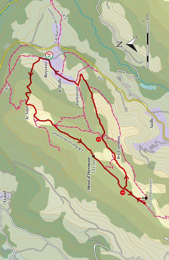
As you face the church go straight up the road keeping the church on your right (do not go left to le Bulle, Lanversin). There are red/white GR signs on electricity poles nearby as this is part of the Balcon du Léman. The road goes briefly between old stone walls, and comes to a little shrine called l’Oratoire des Pas, dated 1723. Inside there is a statue of the Virgin Mary.
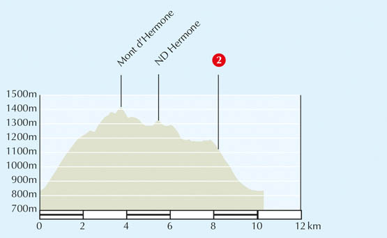
At the signpost headed ‘l’Oratoire – alt. 800m’ just before the shrine, go up left towards Montagne des Soeurs/Mt d’Hermone/Chapelle d’Hermone. This is a wide jeep track going up steeply for 400m through bushes and light woodland. Down on the left there is a lovely view of Reyvroz and the church. Keep straight on this jeep track following red/white markings and yellow arrows on green (ignore the path off to the right marked ‘Voie sans Issue’). You enter a zone of coniferous trees, and later there is a fork right with a red/white warning cross to the left. The track winds upwards. Continue straight up at a small crossroads (there is a power line here), going through a fence and reaching a clearing with a big barn on the left and a signpost at le Saut (1150m) (55min).
Following the signs to Montagne des Soeurs/Mont d’Hermone, cross the clearing on the main track. Shortly afterwards you come onto the open pastureland of Mont d’Hermone.
This is now called the Montagne des Soeurs (mountain of the nuns) but in the 11th century it was called the Chemin des Chartreux, as the Carthusian monks used to cross here when they were going from their monastery near Lac Vallon to their property in Thonon.
Continue straight on the track – there is a cross on the top of the hill to your right – to reach a signpost ‘Montagne des Soeurs – alt. 1217m’ next to a chalet, with a TV transmitter and a small hut beyond. Following the sign to Chapelle d’Hermone, turn left in front of the chalet on a wide grassy track (red/white markings), which goes up the hill, shortly joining a potentially muddy jeep track. This takes you through a fence into coniferous wood and an intersection at another signpost ‘Montagne des Soeurs – alt. 1250m’ (1hr 10min).
Go left towards Mt d’Hermone/Chapelle d’Hermone following the red/white markings. Some 100 metres further on there is a signpost headed ‘Alt. 1260m’ indicating straight on to Mont d’Hermone (left goes to Vailly/Reyvroz). A few metres later at a fork go left, still on the jeep track. You are now climbing up in a series of steep switchbacks along a very wide ridge through woodland and bushes. Keep to the main upward path until you come out in the open to reach the highest point of the ridge of Mont d’Hermone (1413m) where there is a wooden sign (1hr 40min).

Chapel of Notre Dame d’Hermone
From Mont d’Hermone there are extended views to the right and left. To the right you look over Lake Geneva with the Jura mountains on the horizon, and to the left, beyond the valley, are the peaks of the Chablais: the Dent d’Oche, Cornettes de Bise, Mont Chauffé, Mont Billiat, Pointe d’Ireuse and Rocher de Nifflon. In the foreground, over to the right, is the Montagne d’Hirmentaz in the Vallée Verte.
The path undulates along the top of the ridge, dropping down through tall pine forest and then up again, to reach a wooden signpost headed ‘les Combes – alt. 1350m’ 1 (1hr 55min). Left goes to the chalets of les Combes, which is 10mins further, and is the path you will take on your return. Keep straight on towards Chapelle d’Hermone, passing a wooden signpost indicating left to le Plansuet/Vailly. Shortly after a windsock for paragliding, the Chapel of Notre Dame d’Hermone is visible on your left and you can go to it directly up a grassy path (2hr 15min).
CHAPEL OF NOTRE DAME D’HERMONE
The Chapel of Notre Dame d’Hermone is situated on an open spur at the end of the Mont d’Hermone ridge and has a beautiful uninterrupted view. It has a steeple with a cross, and on top an impressive weather vane in the shape of a cockerel – rather a pagan finish, but typical of many churches in this region. On the roof is an imposing white statue of Our Lady and at the side a more modern cross with ‘1975 Année de la Reconciliation’ marked on it. There is also an outside stone altar, and it is still the custom on Whitsunday, on the Feast of the Assumption (15 August) and on Our Lady’s Birthday (8 September) for people to follow the Stations of the Cross up to the church and then hear open-air mass.
For 500 years a chapel has stood on this spot, although it has been destroyed and rebuilt several times over the centuries. More recently it was renovated in 1979 and the old doors were replaced in 1989, the year of its centenary. Take time to read the two poems attached to the door. The first, entitled ‘Aujourd’hui est à Toi’, reminds you of the importance of making the most of today; the second, entitled ‘Prendre le Temps’, reminds you of the importance of taking time to reflect, to listen, to relax, to love and to pray.
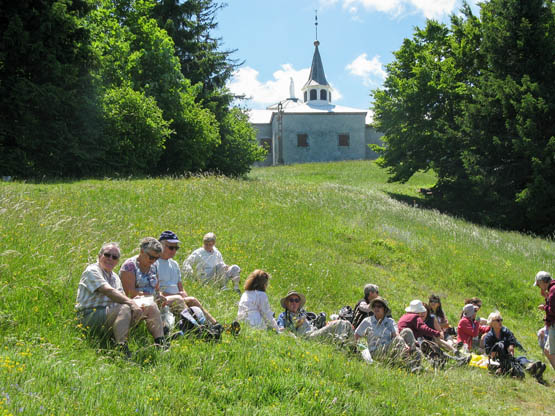
Lunch stop at the chapel
From the signpost ‘Chapelle d’Hermone – alt. 1326m’ (just below the chapel towards the Stations of the Cross) follow the signs to Mont d’Hermone/Reyvroz and retrace your steps back along the ridge to the wooden signpost headed ‘les Combes’ 1. Take the second turning down on your right to les Combes/Reyvroz, following the yellow splashes carefully. The path winds back round the contour of the mountain through bushes and then conifers alternating with open spaces, and then goes in front of an abandoned barn before reaching a junction with a wooden signpost indicating left to les Combes and straight on to Reyvroz (2hr 45min).
Go straight on, towards Reyvroz. The path continues round the contour of the hill and there are bare patches of hillside where the trees have been taken for logging (all replanted with fir saplings), followed by dense patches of coniferous wood. You come to a wooden signpost at a sort of crossroads 2. Following the sign indicating ‘Reyvroz par les 2 Sapins’, continue straight on, onto a narrow grassy path marked by yellow splashes. It is still winding round the mountain through patches of dense coniferous wood and reaches a wooden signpost (3hr 30min).
Go right towards Reyvroz, on a path going steeply down through beech wood, to reach a fence on your right with open fields beyond and a big barn. Do not bear right into the field but continue straight, following the ridge steeply down through continuing beech wood; the path is not very obvious so look out for the yellow circles. You emerge onto a wide track leading to the meadow and barn up on the right. Do not take this but go down to the left (clearly signed) and a few minutes later follow the wooden signpost straight on towards Reyvroz (left goes to Chenoz, back up to les Combes/Notre Dame d’Hermone). Continue down this steep path, following the signs to Reyvroz and going straight at a crossroads. You then come to a wooden chalet called les Deux Sapins, aptly named after the two big fir trees on your right.
From les Deux Sapins you have a lovely view of the little village of Reyvroz, dominated by its church down below on the left, with the ridge of Pic des Mémises and Pic Boré behind. There is also a magnificent view of the twin peaks of the Dent d’Oche.
Continue down left on the wide track to a T-junction where you bear right at the bottom by some dilapidated old wooden signposts that are difficult to read. You pass through the lovely old farm buildings of Lanversin. You then come to a tarmac road. Walk through the hamlets of le Bulle and Chez le Gaud to arrive at the village of Reyvroz (4hr).
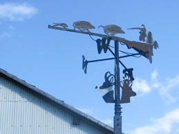
The hunting weather vane at Lanversin
| Start/Finish | L’Ermont, 1010m |
| Distance | 9km |
| Total ascent | 760m |
| Grade | Medium |
| Time | 4hr 30min |
| Maximum altitude | 1775m |
| Map | IGN 3428 ET Thonon/Evian 1:25,000 |
| Access | From Bellevaux, turn left in front of the church and immediately after, turn right on a narrow road at small wooden signposts indicating Pâques and le Frêne. Go along this winding road for about 4km, through the hamlets of Pâques and le Frêne. Cross the bridge at the entrance to l’Ermont and continue to the end of the road where there is space for parking on the left. |
| Signposting | Good – new signposts and yellow splashes |
This is a beautiful walk with magnificent views in a really unspoilt area of the Haute Savoie, passing attractive old chalets and a tiny chapel high on the mountain. The Nifflon is very different from the rounded, wooded Pointe de la Gay nearby, for it is a rocky limestone mountain, the name deriving from the Latin nec fluere, meaning ‘no flowing water’. The rainwater filters underground through large rocky holes, called tannes, where snow collects in winter and lingers throughout the year. The lack of water in dry summers was a problem for farmers who brought their animals up here to graze, and they constructed ladders to collect snow from these holes, one of which you pass on the walk.
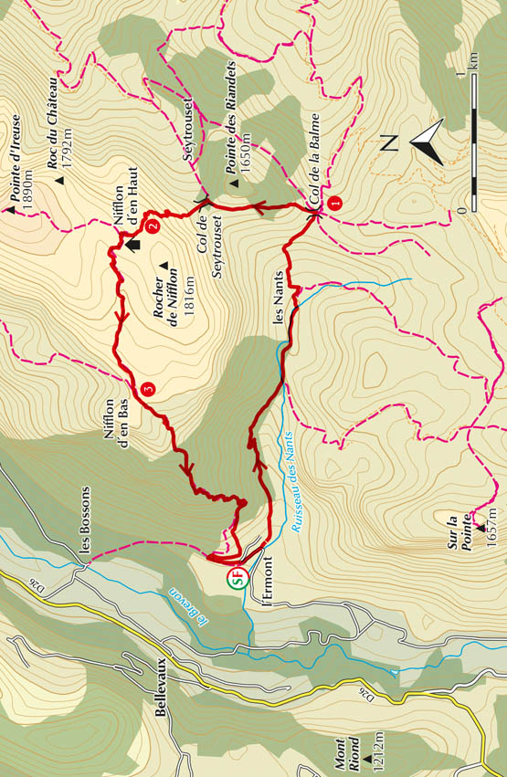
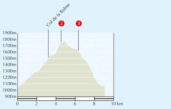
Cross the road to the four signposts, and turn right towards les Nants/Col de la Balme/Nifflon d’en Haut par le col de la Balme. Walk through the hamlet of l’Ermont and at the last of the houses the road becomes a jeep track. After 5mins, it joins up with another jeep track coming up from the right, at a wooden signpost pointing back to l’Ermont. The woods slope upwards on the left and the Ruisseau des Nants, often dry, flows through a ravine on the right. Continue along the jeep track to pass a small chalet on a corner and then a pretty little shrine, the Oratoire de la Dent.
The notice on the Oratoire de la Dent, built in the 16th century and restored in 2007, tells you that it was built to atone for the murder of the last Protestant pastor of Bellevue, killed on this spot when the Haute Savoie was converted back to Catholicism after the Reformation.
Soon after you reach a signpost where you go straight ahead towards les Nants/Col de Balme/Nifflon (40min). Here the stream crosses under the track, and is now on your left as you go through an attractive gorge which then levels out into a narrow valley with meadows and the large rocky mountain of the Rocher de Nifflon on the left. You arrive at the chalets of les Nants and, after crossing a metal bridge, there is a signpost headed ‘les Nants – alt. 1300m’, in front of an old barn just before the road bears to the left (1hr).
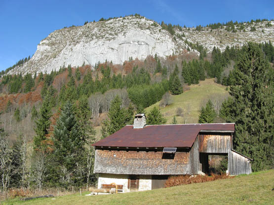
Rocher de Nifflon from les Nants
Turn left following the sign Col de la Balme/Nifflon d’en Haut/Pointe de la Gay (right goes to Tré le Saix). This is a narrow, fairly steep path, with a row of firs on the right, which reaches a meadow with an attractive old chalet on the left. Follow up the slope of the meadow to a wooden signpost. Do not follow the sign saying ‘Nifflon Direct’, but go towards Col de Balme/Nifflon par le Col de la Balme, and after about 200 metres you will come to a wooden signpost on a tree pointing up to Col de la Balme. The path climbs up through coniferous forest, steeply in places, to the signpost at Col de la Balme (1445m) 1 (1hr 30min).
The Col de la Balme is an open shelf with high grass and lots of flowers in summer, and a small wooden chalet to the left. The walk up the Pointe de la Gay (Walk 14) goes off to the right here. Below is the village of Seytrouset and straight ahead is a magnificent view of the high peaks of the Chablais, including the Cornettes de Bise, Mont Chauffé and Mont de Grange, with the Dents du Midi on the horizon.
At the signpost, turn left past the chalet to reach the next signpost and take the left fork towards Seytrouset par Col de Seytrouset/Nifflon d’en Haut. This is a narrow path that climbs up fairly steeply through meadows full of flowers, and then enters woods, with lots of knotted tree roots, but is well defined and clearly marked with yellow splashes. It levels out and curls round the mountain, with lovely views through the trees over the Vallée du Brevon. Just after a post with a yellow arrow you come out into an open meadow and the signpost at Col de Seytrouset (1564m), with the imposing Rocher de Nifflon to your left (1hr 55min).
Following the signs to Nifflon d’en Haut, turn left on a narrow path going up beside a fence. The path climbs steeply up the hillside, still clearly marked with yellow splashes, getting nearer and nearer to the rocky surface of the Rocher de Nifflon, with the chalets of Seytrouset directly below. As you climb higher, the path gets rockier and bends to the right to reach a small col at the top of the steep bit 2 (2hr 40min).
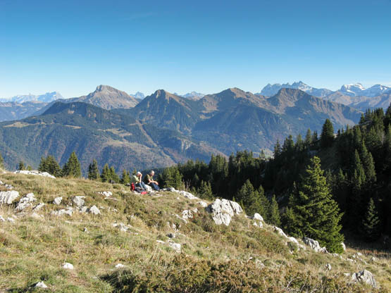
Chablais peaks from Rocher de Nifflon
The highest point of the Rocher de Nifflon (1816m) is over to the left, but it is rather a scramble to get there and is not included in this route description. The col is a good place for a picnic, as there is a magnificent panorama of all the Chablais peaks, including the Dent d’Oche, Cornettes de Bise, Mont Chauffé, Mont de Grange, Roc d’Enfer and Dents du Midi. You can also see les Diablerets and Mont Blanc, with Lake Geneva in front and the Jura range a dark smudge on the horizon. After the rocky scramble up, it comes as a surprise that the other side the mountain falls gently down to a grassy bowl with a collection of chalets and another ridge beyond.
Take the path down into the grassy bowl, past a post with a yellow top, to reach the tiny chapel and the chalets of Nifflon d’en Haut (2hr 50min).
This little chapel was originally constructed in wood in 1796 by the parish priest of Bellevaux, who decided to close the village church at the time of the French Revolution and celebrate mass on the mountain. He dedicated the chapel to Notre Dame des Neiges (‘Our Lady of the Snows’), probably because of the numerous snow patches which the shepherds collected to water their flocks. In 1821 the wood was replaced by stone, and in 1886 the chapel was again renovated and the attractive onion-shaped steeple was added, topped with an imposing weather vane in the shape of a cockerel.
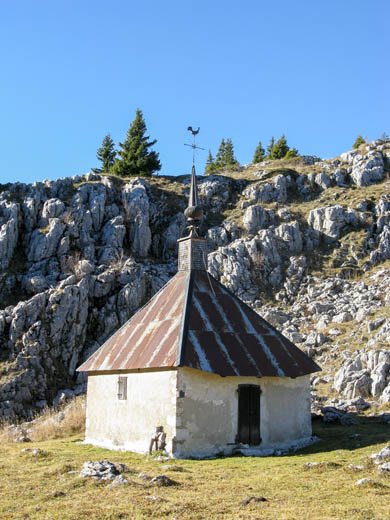
Chapel of Notre Dame des Neiges at Nifflon d’en Haut
Take the path through the chalets, one of which is a small refuge, and up to the signpost ‘Nifflon d’en Haut – alt. 1760m’.
The Refuge de Nifflon has bunks for 10, and is equipped with stove and cooking utensils, but no drinking water. It is unsupervised and the key is available at Bellevaux Tourist Office, www.alpesduleman.com.
Go left, following signs to Nifflon d’en Bas/l’Ermont (straight on is indicated Pointe d’Ireuse, which is the peak ahead). The wide path descends steadily to reach a wooden structure labelled ‘Tanne à Neige’, with an arrow pointing to a tanne 50 metres away.
The information board inside the shelter explains that tanne is the local dialect for one of the big rocky holes where snow remained all year. In very dry summers the farmers would lower ladders to climb down into the hole to collect the snow in big wooden barrels, which would then be left on the roofs of their chalets to melt for the animals. This was hard work as a full barrel weighed 80kg, and one cow drank 50 litres of water per day. Despite the lack of water, the pastures are very fertile and the butter from here has a special rich flavour.
If you follow the arrow up into the woods, you get to the tanne, which still has a rickety wooden platform part of the way down.
Continue along the path, probably an old mule track, which curls down into a narrow valley. It is a pleasant, rocky walk, sprinkled with coniferous and rowan trees, where you will find lots of flowers and butterflies in summer, and moss, bracken and various mushrooms in autumn. The path levels out through woodland, winding round the side of the mountain, rather like the path coming up, with a lovely view in front of Lake Geneva, and reaches the signpost at Nifflon d’en Bas3 which is a sort of bowl, open at both ends and consisting of a few chalets and a large wooden cross (3hr 25min).
There is a good viewpoint just 40m higher on the rocky promontory up to the right, called the Rochers de la Mache, with another cross on it. From here you can see over Lake Geneva and all the peaks of the Chablais and the Vallée Verte, with the village of Bellevaux down in the valley.
Follow the signs down the path to l’Ermont. The path winds down through grassy meadows and eventually into coniferous woods where it is more defined, with a wooded ravine on the left. As you get lower the path becomes steeper and can be slippery after rain or when covered by leaves. At the signpost ‘le Reposoir – alt. 1340m’, where there is a view into the valley, bear left, following the signs to l’Ermont (4hr).
The path descends steeply for quite a while until you come out of the woods into meadowland, with a view below of the village of l’Ermont, and then enters steep woodland again. It finally comes out into more meadows to reach a wooden signpost. Turn left (not signed) on a grassy path which meets a jeep track at a signpost at l’Ermont (1040m). Continue straight on towards les Nants to reach the four signposts at the start of the walk, where your car is parked (4hr 30min).
| Start/Finish | L’Ermont, 1010m |
| Distance | 12km |
| Total ascent | 830m |
| Grade | Medium |
| Time | 5hr |
| Maximum altitude | 1800m |
| Map | IGN 3429 ET Bonneville/Cluses 1:25,000. Note: Bellevaux village is off this map, but not Pointe de la Gay |
| Access | From Bellevaux, turn left in front of the church and immediately after, turn right on a narrow road at small wooden signposts indicating Pâques and le Frêne. Go along this winding road for about 4km, through the hamlets of Pâques and le Frêne. Cross the bridge at the entrance to l’Ermont and continue to the end of the road where there is space for parking on the left. |
| Signposting | Adequate – some new signposts, posts with yellow arrows on green and yellow splashes |
The Pointe de la Gay is in an unspoilt part of the Haute Savoie, where you will meet few other walkers, even in summer. Although next door to the rocky Rocher de Nifflon, it is a complete contrast as it is a grassy, wooded mountain covered with alpenrose and bilberry bushes, with open alpine pastures on the way back. It is a delightful walk at all times of the year, but especially in summer when there are many flowers – however, it might be wise to wear long trousers as some of the paths go through very long grass. From the summit there are dramatic views of the Mont Blanc massif and the surrounding Chablais peaks, including the Roc d’Enfer. You might even see a golden eagle.
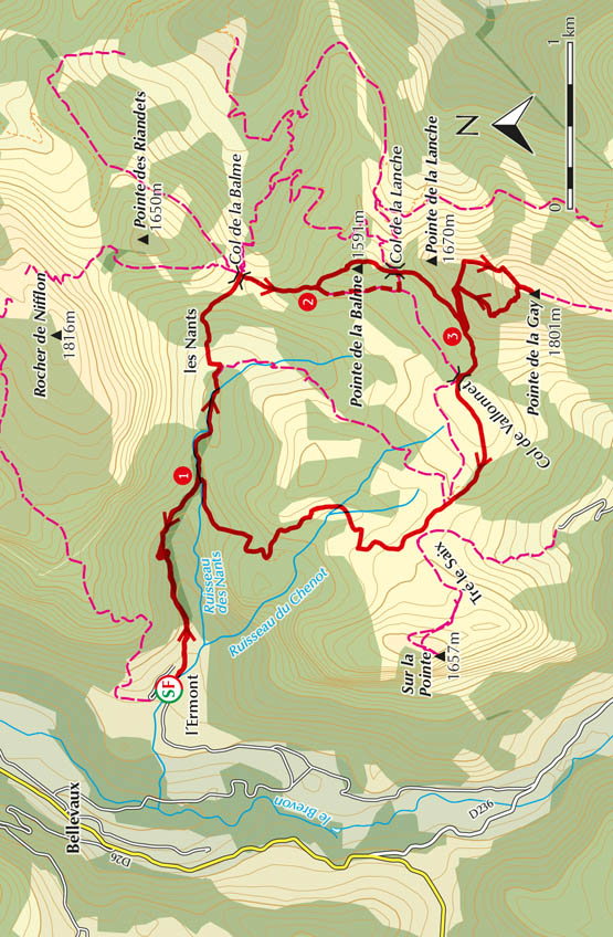
Cross the road to the four signposts, and turn right towards les Nants/Col de la Balme/Nifflon d’en Haut par le col de la Balme. Walk through the hamlet of l’Ermont and at the last of the houses the road becomes a jeep track. After 5mins, it joins up with another jeep track coming up from the right, at a wooden signpost pointing back to l’Ermont. The woods slope upwards on the left and the Ruisseau des Nants, often dry, flows through a ravine on the right. Continue along the jeep track to pass a small chalet on a corner and then a pretty little shrine.
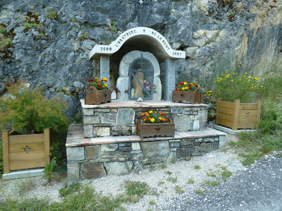
Oratoire de la Dent near l’Ermont: photo Sharon Bryand
The notice on the Oratoire de la Dent, built in the 16th century and restored in 2007, tells you that it was built to atone for the murder of the last Protestant pastor of Bellevue, killed at this spot when the Haute Savoie was converted back to Catholicism after the Reformation.
Soon after you reach a signpost 1 (40min). Continue straight ahead towards les Nants/Col de Balme/Nifflon. Here the stream crosses under the track, and is now on your left as you go through an attractive gorge which then levels out into a narrow valley with meadows and the large rocky mountain of the Grand Rocher de Nifflon on the left. You arrive at the chalets of les Nants and, after crossing a metal bridge, there is a signpost headed ‘les Nants – alt. 1300m’, in front of an old barn just before the road bears to the left (1hr).
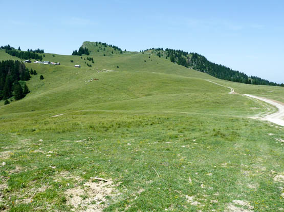
Grassy pastures of Tré la Saix below the Pointe de la Gay: photo Sharon Bryand
Turn left following the sign Col de la Balme/Nifflon d’en Haut/Pointe de la Gay (right goes to Tré le Saix). This is a narrow, fairly steep path, with a row of firs on the right, which reaches a meadow with an attractive old chalet on the left. Follow up the slope of the meadow to a wooden signpost. Ignore the sign saying ‘Nifflon Direct’, but go towards Col de Balme/Nifflon par le Col de la Balme, and after about 200 metres you will come to wooden signpost on a tree pointing up to Col de la Balme. The path climbs up through coniferous forest, steeply in places, to the Col de la Balme (1445m) (1hr 30min).
The Col de la Balme is an open shelf with high grass and lots of flowers in summer, and a small wooden chalet to the left. The walk up the Rocher de Nifflon (Walk 13) goes off to the left here. Below is the village of Seytrouset and straight ahead is a magnificent view of the high peaks of the Chablais, including the Cornettes de Bise, Mont Chauffé and Mont de Grange, with the Dents du Midi on the horizon.
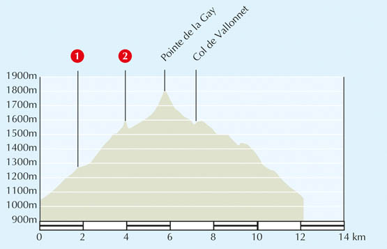
At the signpost turn right, following the sign Col de la Lanche/Col de Vallonnet/Pointe de la Gay. The grassy path climbs upwards between two fences and then through woods, with intermittent red/yellow signs on trees, to reach a signpost headed ‘Alt. 1518m’, indicating Pointe de la Gay, 1hr 5min. Continue through the woods to a junction of paths 2 (1hr 40min). There are two possible routes from here to the Col de la Lanche.
This easier option, taking the right-hand path, goes down through woodland and curls left to reach a clearing with a good view ahead of the Pointe de la Gay. The path is poorly defined across meadowland, but keep slightly left, and then turn left at a signpost up to the Col de la Lanche (straight on goes to Col de Vallonnet).
The main route takes the left-hand path which is the more scenic route, although it is steeper and slightly longer. It climbs up to the ridge, with a drop on your left down to the Morzine valley, to reach the rocky Pointe de la Balme (1591m), from where you have views up to the Pointe de la Gay. There is then a scramble of about 10m down a steep section with chains for support, certainly needed if the rocks are wet. You arrive at a sort of dip in the mountains, which is the Col de la Lanche (1539m) (2hr).
From the Col de la Lanche, continue south, following the wooden sign to Col de Vallonnet/Pointe de la Gay, on a wide new jeep track for about 200 metres before turning off on a small path to your left. This goes upwards and round the Pointe de la Lanche through tall coniferous trees with lovely views of the Rocher de Nifflon on the right. It narrows before reaching a signpost ‘les Profanfas – alt. 1600m’ 3 (2hr 15min).
Turn left towards Pointe de la Gay. Follow the path through fir and nut trees to reach open meadowland and a post after a few minutes. Up on the right you have a clear view of your return path down from the summit. Continue straight through open meadowland covered in bilberry bushes until you get to the crest of the hill (the Pointe de la Gay is up on the right and the Pointe de la Lanche on the left) and another lovely view down into the Seytrouset valley. Turn up right, following the line of the hill, and climb about 140m to reach a post with a yellow arrow on green. Continue on for a few metres to reach a signpost at the summit of the Pointe de la Gay (2hr 55min).
The summit is an ideal place for a picnic, with lovely views in all directions. To the north is Lake Geneva with the Jura mountains on the horizon, and to the south the high peaks of the Chablais, with the Mont Blanc massif in the background. Nearby is the rocky ridge of the Rocher de Nifflon with the hamlet of les Nants nestling in the valley below it, and the path continues along the crest past the Col des Follys to the Roc d’Enfer.
Retrace your steps to the post with the yellow arrow and take the narrow path going down to the left. This is a steep path going down the shoulder of the hill, bearing left then right to reach a post in the meadow. It can get rather lost in high summer in the tall flowers and long grass, so follow the occasional yellow splashes carefully. At the post continue down to the signpost at Profanfas 3 (3hr 15min).
Go left, following the sign Col de Vallonnet/Tré le Saix through a green turnstile. Keep on the path, which becomes a wide track curling down to reach the signpost at Col de Vallonnet (1548m), which is a grassy crossroads in a dip (3hr 35min).
Go straight, following the sign to Tré le Saix on a grassy track, which goes up and over a hill. At the top of the hill follow the track left going over the top of a series of bumps in open meadowland until you meet up with a new jeep track. Follow this for about 100 metres until you reach the signpost headed ‘Tré le Saix – alt. 1480m’. You can see the chalets of Tré le Saix up on your left (4hr).
Follow the signs to l’Ermont crossing the jeep track, and continue over a hump and then down to the forest. You are now on a wide track through scattered woods with a slope to the left down to the Ruisseau du Chenot. Continue past a sign indicating left to the Chalet de Ficlaz as the wide rutted track bears round to the right and goes down steeply through beech wood and coniferous trees. Continue to reach the signpost at the original jeep track going up to les Nants 1 (4hr 30min). Turn left and walk down to where you left the car at l’Ermont (5hr).
| Start/Finish | La Chèvrerie, Lac de Vallon, 1120m |
| Distance | 12km |
| Total ascent | 1000m |
| Grade | Strenuous |
| Time | 6hr |
| Maximum altitude | 2105m |
| Map | IGN 3429 ET Bonneville/Cluses 1:25,000 |
| Access | From Bellevaux, take the D26 towards St Jeoire and after about 2km take the narrow road going down on the left, indicating Lac de Vallon/la Chèvrerie. Continue past the lake and hamlet of la Chèvrerie, and leave your car in the large parking area of Pont de la Joux where there is a café, the Torchon chairlift and an information board. |
| Signposting | Mostly good – new signposts and some sporadic yellow and blue markings |
This is a long, attractive walk which goes over three passes and gives wonderful views of the whole area between Mont Blanc and Lake Geneva. It goes very close to the dramatic Roc d’Enfer and the source of the River Brevon. The information board at the start of the walk, entitled ‘Les Sources du Brevon’, has a map of the area, with details of the river and the Lac de Pététoz. It also indicates that you have a good chance of seeing marmots, chamois and moufflons – in fact, there is a large flock of moufflons near the Col de Foron. In spring and early summer look out for gentians, orchids, alpenrose and martagon lilies.
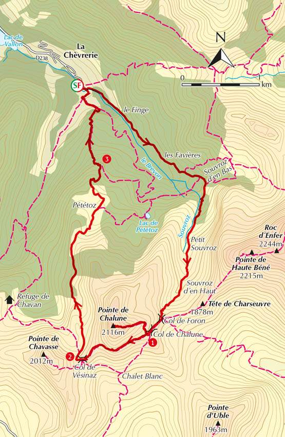
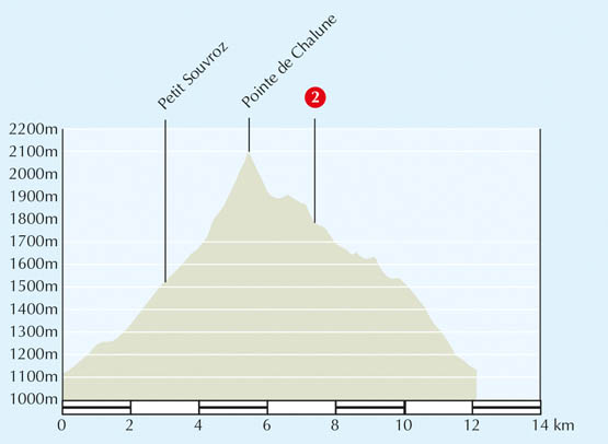
At the Pont de la Joux there are several signposts as it is the starting point for a number of walks. Take the wide track at the side of the chairlift indicating ‘Pointe de Chalune par le col de Foron’. The track gains height gradually, with the River Brevon flowing down on the right. After about 5mins you see the building of le Finge up on the left. Keep straight on, with the stream always on the right, to reach the huts of les Favières (25min).
At the crossroads a little further on, go straight over and carry on up the path to the signpost headed ‘Alt. 1310m’. Go right towards Source du Brevon/Col de Foron/Roc D’Enfer/Chalune. After crossing the stream the path narrows and becomes stonier to reach the next signpost, which indicates Pointe de Chalune 2hr 40 and Col de Foron 1hr (this is clearly not correct, as the signpost further on indicates that it is 1hr 20min).
Continue up the path to the signpost headed ‘Alt. 1449m’ and go towards the Col de Foron. The path curls round the side of the mountain, beneath the huge cliffs of the Roc d’Enfer which tower up on the left. You come out of the woods into an attractive bowl in the mountains, called Petit Souvroz (1hr 20min). You have now passed the Roc d’Enfer, which is back on the left, and you can see the Col de Foron up ahead.

Roc d’Enfer from the Col de Foron
This is rocky country, so keep an eye out for marmots – they announce their presence by a piercing whistle, which is the marmot sentry’s signal to the others that intruders are in the vicinity.
At the signpost ‘Petit Souvroz – alt. 1585m’, continue straight on towards Pointe de Chalune/Col de Foron. The path crosses the meadows past alder bushes and then begins to zigzag steeply up to the Col de Foron, nearly 250m higher. As you get higher, the slopes on both sides of the path are covered with more and more flowers – alpenrose, gentians, orchids, globe flowers and many more. At the end the path gets much steeper and becomes somewhat eroded and slippery before it reaches the Col de Foron (2hr 15min).
From the Col de Foron you can see the steep and exposed path along the Roc d’Enfer to your left, with a clear view of the path coming up from the Chalet de Foron, and if you look behind, you can see the way you have walked up from la Chèvrerie. Ahead are the peaks of the Chablais, with the Dents du Midi and part of the Mont Blanc massif.
Turn right at the col, following the signpost to Col de Chalune which you can see up on the right as you skirt round the mountain. The path is even more eroded and slippery but it takes only 10mins to reach the Col de Chalune1 (2hr 25min). Follow the signs to Pointe de Chalune on a fairly exposed path which goes steeply up for 220m (3hr 10min).
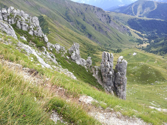
Rock formations on the Chalune: photo Sharon Bryand
From the top of the Pointe de Chalune there are spectacular views of the surrounding peaks, which include the Pointe d’Uble, Roc d’Enfer, Rocher de Nifflon, Pointe de la Gay and the Môle. The Lac de Roy is down below, with the Pointe de Marcelly ridge behind, and you can see Lake Geneva and the Jura in the distance – there are not many viewpoints where you can see so far in all directions.
Retrace your steps to the Col de Chalune 1 and follow the sign to Col de Vésinaz. This is a well-defined path, but towards the end of it, just before the col, you have a big rock to scramble down. After the big rock you meet the path coming up from Chalet Blanc, and climb up between two rocky peaks, the one on the right a streaky pink colour, to reach the Col de Vésinaz2 (4hr). From here you get a lovely view of the rocky west side of the Pointe de Chalune.
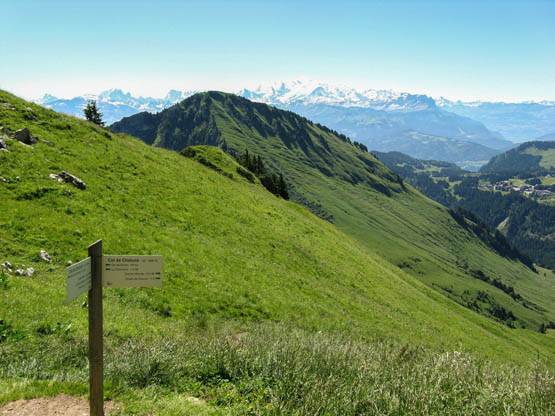
Looking towards Mont Blanc from the Col de Chalune
Go through a green stile to a signpost and follow the signs to Chalets de Pététoz. Walk down the path until you reach the signpost headed ‘Alt. 1760m’ and go right towards Chalets de Pététoz (to the left is the Col de Chavan, which you cross on Walk 16 up the Haute Pointe). The path goes to the right of a wooded hillock, following blue markings and then yellow ones. You are now walking in a very attractive hanging valley with the rocky cliffs of the Pointe de Chalune to the right. The path goes over a rise and undulates down the valley, which widens as it traverses the hillside, with woods in the valley bottom, and you can see a road across the other side. Continue downhill, past the Col de Jorat, making for the chalets you see below, which are set in beautiful open meadows, to reach Pététoz (5hr).
At the signpost at Chalets de Pététoz go towards Pont de La Joux (direct). This goes slightly left in front of the first chalet on a grassy path through meadowland, which takes you by a second chalet called ‘Chardons Bleu’ (blue thistles). There is an iron cross in the field up right. Enter woodland through another green stile to gain a jeep track through coniferous wood (marked with red/white GR signs), to reach a big open clearing. Take a narrow steep path to the left 3 following a sign indicating la Chèvrerie. The steep path takes you down to a second clearing. Go straight across and continue downwards. When you see the jeep track ahead, do not try and go through the fence, but keep to the track bending right where there is a way through (signposted back to Pététoz).
Turn left and shortly after you reach an unpaved road and signpost headed ‘la Joux – alt. 1141m’, where you turn right and follow the signs to Pont de la Joux. Walk across the River Brevon on a green bridge into the parking area in la Chèvrerie (6hr).

Trumpet gentians
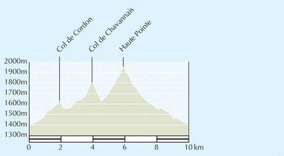
| Start/Finish | Sommand, 1410m |
| Distance | 10km |
| Total ascent | 810m |
| Grade | Medium |
| Time | 4hr 45min |
| Maximum altitude | 1960m |
| Map | IGN 3429 ET Bonneville/Cluses 1:25,000 |
| Access | From St Jeoire, take the D907 to Mieussy. Go through the village and, at a roundabout just after, take the D308 towards Messy/Sommand/Col de Ramaz. Continue uphill for about 11km to Sommand. Where the main road to Praz de Lys bears left at the Hotel Vacca Park, go straight across towards the large parking area for the ski season and park opposite the hotel. |
| Signposting | New signposts and posts with yellow arrows on green, as well as some red/yellow and yellow markings |
This is a varied walk in unspoilt and peaceful mountain country to the north of Sommand, away from the ski lifts linking with Praz de Lys on the south side. Do not do this walk too early in the season as snow can linger on the steeper north side making walking round impossible. There are three cols to cross and some steep sections, including the rocky scramble up the last few metres to the summit of the Haute Pointe. However, the summit is worth the extra effort as you get a panoramic view of the entire region, including the Mont Blanc massif.
For parts of this walk you are in fenced-off alpine pastures where no dogs are allowed, even on a lead, and where the flocks are guarded by large white dogs called pastous. Do not get near these as they are brought up to protect the sheep, and will attack if provoked.
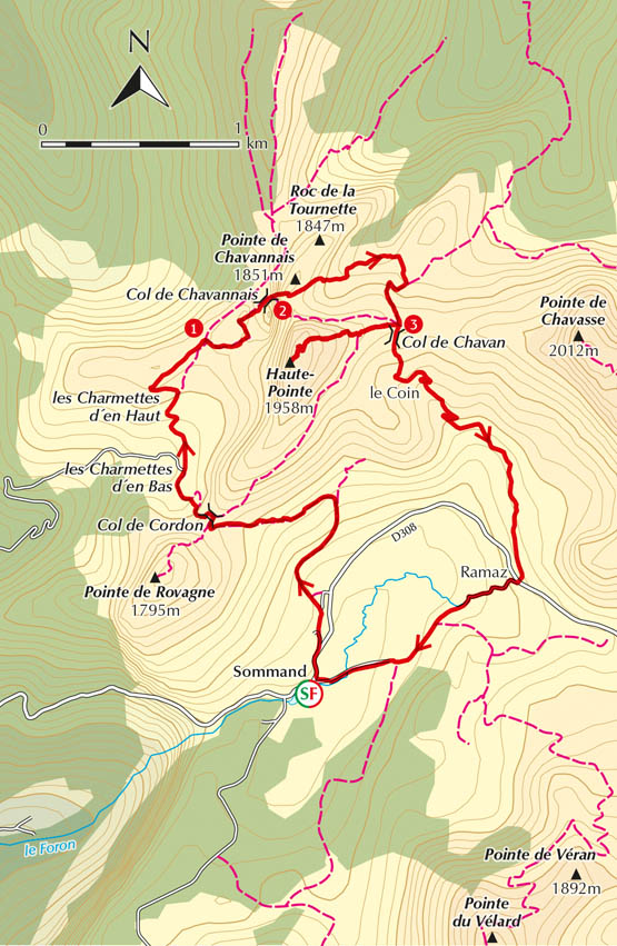
At the Hotel Vacca Park, turn right and walk up the Route du Col de Ramaz for about 100 metres to the restaurant ‘le Matafan’. At a yellow arrow on green, leave the main road and take the road on the left. Keep on this road, which turns into a stony track, and follow the yellow arrows on green through the scattered chalets of le Mary. Continue towards the next chalet, and just before you reach it, take the narrow path to the left, at a yellow arrow by a stone wall (15min).
The path winds uphill through grassy meadows bright with flowers, and after about 10mins, at a post with a yellow arrow, bears left into the trees. Just before the col the path goes through an attractive dell where there are lots of orchids, tall yellow gentians and white daisies. When you reach the signpost at Col de Cordon (1636m), you can see both ways – back to the Mont Blanc massif and Col de Ramaz, and ahead to the mountains of the Vallée Verte, les Voirons and the Jura range on the horizon (45min).
Ignore the path bearing right and turn hard left on a narrow stony path which zigzags steeply down for about 10mins into a wide attractive valley with farms and grazing cows. Just before the farm at Charmettes d’en Bas (1549m), you reach a jeep track at a signpost where you turn right and go up the jeep track to reach the chalets of Charmettes d’en Haut (1620m) (1hr 5min).
This is marmot country, and if you keep quiet you may well see one of these furry creatures running across the rocks. Listen for the piercing whistle which is uttered by the marmot who is acting as sentry to warn the others that danger is approaching.
Go past the chalets and, at the next corner, you can either take the narrow, grassy path to the right, or stay on the jeep track, to reach the next col. You can already see a signpost on the skyline, so make for this landmark. Eventually you meet up with the jeep track and reach the signpost headed ‘Alt. 1660m’ 1 (1hr 15min).
Do not go straight on through the gate, which seems the obvious way to go, but turn right, following the signs to Col de Chavannais/Col de Chavan/Haute Pointe. This is a narrow, grassy track which curls back the way you came but higher, and is marked with red/yellow splashes. The path goes very steeply up the side of the mountain, through slopes of flowers. After about 20mins you reach a ridge with a steep drop on your left. Continue along the top of the ridge to the Col de Chavannais (1800m), and go on to the signpost, about 10m down the other side 2 (1hr 45min).
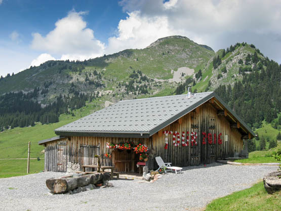
A chalet below the Haute Pointe
At the signpost do not go right, following the signs to Col de Chavan/Haute Pointe/Sommand, as this is a difficult, rocky path across scree slopes, where the snow lingers. Go left, following the signs to Chalet de Chavan/la Chèvrerie, down a stony path, marked by yellow splashes. There is a short section on scree, so watch your feet, but the path loses height rapidly to reach grass and small bushes. After about 30mins you come to a fork where the left path comes up from the Chalet de Chavan (this is not signed, so look out for it). Take the right fork and follow the yellow and then red/yellow markings steeply uphill to the signpost at the Col de Chavan (1757m) 3 (2hr 45min).
Follow the sign up to the Haute Pointe, which says 40min. The path is marked with intermittent blue splashes and is steep and stony at first. It then goes through a meadow with sheep, ending with a scramble up the rocks to the summit where there is a cross (3hr 25min).
The view from the summit of the Haute Pointe is spectacular. Starting from the west you can see Lake Geneva, the Jura and the Salève; the Pointe de Miribel, the Hirmentaz ridge and the Voirons in the Vallée Verte; the Grand Rocher de Nifflon and Pointe de la Gay near the village of Bellevaux, with the Dent d’Oche in the background; the Pointe de Chalune with the Roc d’Enfer behind; the Pointe d’Uble and the cross of the Pointe de Marcelly dominating Taninges; and finally the lone Môle peak. On the southern skyline are Mont Blanc and the higher Alpine peaks.
Return by the same route to the Col de Chavan3 (3hr 45min) and follow the sign to Chalet du Coin/Sommand down the grassy hillside to the big farmhouse of le Coin at the start of a jeep track. Walk down the jeep track past another farm to reach the main road going from Sommand to Praz de Lys, and cross this to join another smaller road going steeply down through some attractive chalets to reach a cross. Turn left, still on the road, to the large parking area and the hotel where your car is parked in Sommand (4hr 45min).
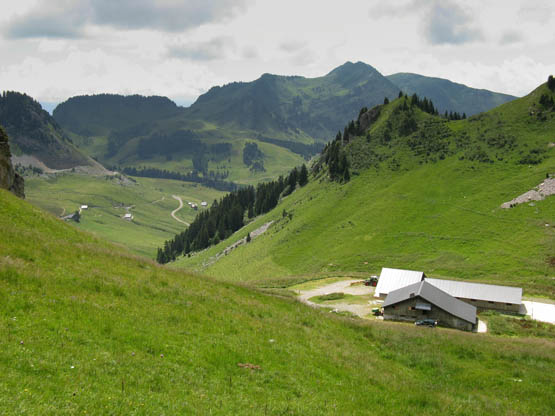
Walking back down to Sommand
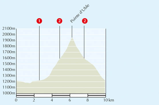
| Start/Finish | Near Bonnavaz, 1220m |
| Distance | 10km |
| Total ascent | 785m |
| Grade | Medium |
| Time | 5hr |
| Maximum altitude | 1965m |
| Map | IGN 3429 25 Bonneville/Cluses 1:25,000 |
| Access | From St Jeoire, take the D907 to Taninges and then the D902 towards les Gets, and at le Pont des Gets turn left on the D328 towards Praz de Lys. Continue on the D328 through Bonnavaz for about 1km to les Plattes where you park opposite a farm. |
| Signposting | Good – new signposts and posts with yellow arrows on green |
Although the start of this walk is along roads, once you get higher you are in attractive pastureland, with lovely meadow flowers in springtime and slopes of early purple and common spotted orchids higher up. In autumn the woods are full of interesting fungi, including the large red variety with white spots. From the summit ridge there is an unforgettable panorama of the surrounding peaks, especially of the nearby Roc d’Enfer, one of the most impressive mountains in this area.
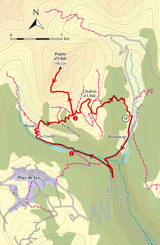
From the signpost at les Plattes, walk down the D328 which you drove up. Shortly after you pass the hamlet of Bonnavaz on the right, where there is an attractive little chapel with a huge golden weather vane in the shape of a cockerel, and an imposing wooden door. The road crosses the Ruisseau de Boutigny which rushes attractively over boulders before joining the River Foron, and the meadows at the side of the road are carpeted with flowers. After about 20mins you reach a crossroads.
Turn right on the D308 towards Praz de Lys and after about 100 metres, on a hairpin bend, take the narrower road which goes straight on towards la Crotte. You are walking along an attractive, narrow wooded valley with the Boutigny stream rushing down on the right in a ravine and a wooded hill up on the left. After 10mins the road levels with the stream and becomes flat and easy. You pass a signpost on the left, headed ‘Pont de la Crotte – alt. 1200m’ 1, before crossing over a bridge into coniferous trees, where you will find a variety of fungi growing in the autumn. You reach a large wooden barn on the right and a signpost at la Crotte (1235m) (50min). The road walking is now over.
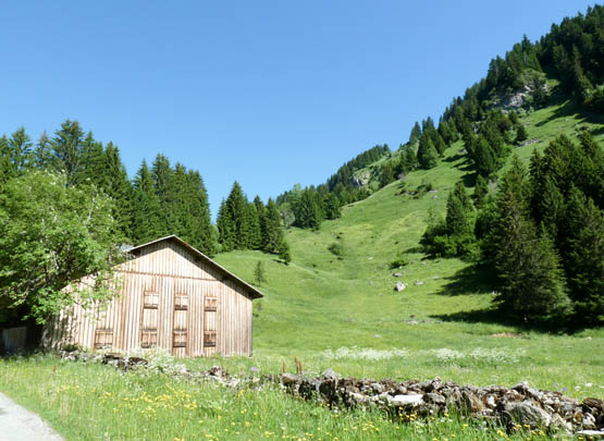
A barn at la Crotte below the Pointe d’Uble: photo Sharon Bryand
Leaving the road, which continues on as a jeep track, take the wide path up to the right, signposted ‘Pointe d’Uble/les Munes’. Continue on the path, which becomes narrower and is bordered by pines. A few minutes later you come into open meadowland and zigzag up to reach the chalets of Rosset (1hr).
Go straight past the three chalets and follow the signs up to Pointe d’Uble. Continue on the rocky path which then bears to the right to pass two large troughs, going upwards round the contour of the slope through coniferous trees. You go through a wooden barrier and out into attractive meadowland, passing the ruins of les Perrières, which are almost completely hidden, to reach a post with a yellow arrow on green.
Go up to the left, ignoring a path off to the right and, a few minutes later, bear right at a further post with a yellow arrow. The path zigzags up through another patch of coniferous forest and then comes out again into open meadowland, continuing upwards to reach a humpy ridge where there is a wooden board saying ‘Alpage d’Uble’, and a signpost headed ‘Alt. 1600m’ 2 (2hr 10min).
Go left following the sign Pointe d’Uble 1hr (straight on goes to Bonnavaz, which you will take on your return). You are now climbing steeply up to the summit of the mountain over open pastureland on a narrow path, which winds over to the left then right. The terrain suggests that the pointe will be another grassy hump, but in fact you come on to a ridge, the ground dropping away in front very abruptly, which is unexpected. This is the top of the Pointe d’Uble (1963m) (3hr 15min).
From the Pointe d’Uble you can see the Roc d’Enfer straight ahead, with the Pointe de Chalune to the left and the Haute Pointe behind. Below to your left is the Lac de Roy and the Pointe de Marcelly above Praz de Lys, while behind you to the south is the Vallée de l’Arve. If you walk to the end of the ridge, which takes five minutes, you will appreciate the sudden dramatic drop.
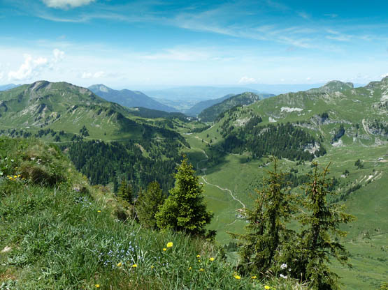
Looking down on the Col de Ramaz and Sommand from Pointe d’Uble: photo Sharon Bryand
Retrace your steps to the board saying ‘Alpage d’Uble’ 2, and turn left, following the sign to Bonnavaz. You can see the Chalets d’Uble below, but you never actually reach them. The track goes down, passing a small wooden chalet on the right. Go behind the chalet through a wooden barrier, and follow the grassy jeep track, which takes you down to the forest. At a T-junction go right (left goes to the Chalets d’Uble) and keep on the wide, grassy path until you meet a wider track (4hr 25min).
Turn down left and shortly after the path becomes a wide jeep track. You go through a wooden turnstile and into coniferous woods. After about 30mins of winding down through the woods, you reach the road at les Plattes and your car (5hr).
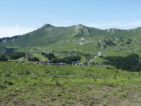
View of Praz de Lys and the Marcelly ridge from Pointe d’Uble: photo Sharon Bryand