
Looking towards the Roc d’Enfer from the Col de Chésery (Walk 28)

Looking towards the Roc d’Enfer from the Col de Chésery (Walk 28)
The Val de Morzine follows the third tributary of the River Dranse, which flows almost due south between the other two. The walks in this valley are all in the upper reaches of the river near its source, to the south of the Val d’Abondance.
If you follow this branch of the Dranse up from Bioge, you pass through the village of St-Jean d’Aulps where the 12th-century Cistercian monastery, now in ruins, once owned all the surrounding lands, including Morzine itself. The inhabitants produced crops and livestock for the monastery until its destruction in 1531 during the Reformation, after which they were free to farm the land for themselves. However, it was not nearly as fertile as in the nearby Val d’Abondance, and despite some income from slate mining, the village remained a quiet backwater until 1862 when a road was constructed linking it with Thonon. Gradually tourism began to develop, and the first hotel was built in 1925, followed by the first ski lift in 1934. Since then the town has gone from strength to strength, especially since the 1970s when the higher resort of Avoriaz was constructed and the Portes du Soleil ski complex established, linking 12 resorts in France and Switzerland.
Morzine is now a lively town in both summer and winter, and has managed to retain a certain charm, with some old chalets in the centre. It is easily accessible from both the north and the south, and has plenty of accommodation, with more than 50 hotels as well as several campsites.
The town is surrounded by high mountains, and not all of them are marred by ski installations. Dominating it to the south is the Pointe de Ressachaux, a little visited peak which provides a spectacular viewpoint over Morzine and Avoriaz. To the east are lovely walks up to the lakes and high cols on the Swiss border, once used by smugglers between France and Switzerland, as were the cols above Châtel in the Val d’Abondance and above Samoëns in the Haut Giffre. The most beautiful walks are up to the cols above the Lac de Montriond and the smaller Lac des Mines d’Or, and to the Col de Brétolet, just over the border, where there is an ornithological station monitoring the thousands of birds which migrate over here every spring and autumn.
The driving directions for walks in this section are from Morzine.

Dents du Midi from the Col de Cou (Walk 30)
| Start/Finish | Les Lindarets, 1495m |
| Distance | 12.5km |
| Total ascent | 590m |
| Grade | Medium |
| Time | 4hr 30min |
| Maximum altitude | 1995m |
| Map | IGN 3528 ET Morzine Massif du Chablais 1:25,000 |
| Access | From Morzine, take the D228 to Montriond, and then, still on the D228, follow signs to Lac de Montriond/les Lindarets. The road goes past the Lac de Montriond on the right and on to les Lindarets. In the middle of the village turn right at the Restaurant les Rhodos and go all the way through the village to les Marmottes bar/restaurant. Turn left into this wide shallow valley and park just beyond les Marmottes, at the Chaux Fleurie chairlift. |
| Signposting | Mostly good – new signposts, posts with yellow arrows on green and red/white markings for the GR5 between the Col de Chésery and the Col de Bassachaux |
Apart from the initial climb up to the Col de Chésery, this is an easy balcony walk between a lake and two cols, with lovely views down to the Lac de Montriond and, at the Col de Bassachaux, towards the Val d’Abondance and Mont de Grange. In early summer the slopes are bright with flowering alpenrose, and in autumn with the russet coloured leaves of bilberries.
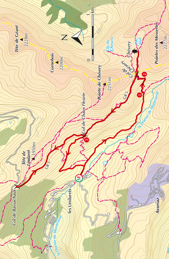
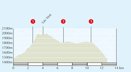
Les Lindarets is a busy little place in summer and winter, with numerous chalet-type restaurants. It is known as the village of goats, as in summer these wander around freely, and anything that can be made from goatskin is on sale in the shops. In winter it is one of the 12 resorts of the Portes du Soleil ski complex, with several chairlifts and ski-tows linking the slopes between France and Switzerland.
From the wooden signpost ‘les Marmottes’, take the wide jeep track up the valley towards the Col de Chésery, passing under the Chaux Fleurie chairlift. After 5mins you reach the signpost ‘la Lécherette – alt. 1520m’. Go straight on, towards Cascade des Brochaux.
After about 20mins you reach another signpost ‘les Brochaux – alt. 1585m’, just before the chairlift of les Mossettes. Turn left towards Col de Chésery/Lac Vert, and continue up this wide jeep track through lovely alpine pasture.
In summer there are a variety of flowers covering the meadows, including lots of marsh orchids, cotton grass and bird’s eye primula where the ground is damp, with alpenrose, gentians, pulsatilla anemones, moss campion, martagon lilies and several species of orchids as you get higher.
Continue on the jeep track for about another 40mins, until the point where the chairlift is closest to the track and there is a large rock on the left, with Chésery and an arrow painted on it in yellow. Note that there is no signpost here, where you would expect one 1 (1hr).
Follow the arrow left towards Chésery (the jeep track goes straight on to the south, to the Pas de Cuboré and the Pas de Chavanette). This is a narrow but well-defined path that goes steeply uphill under the chairlift, and then bears to the right across slopes of alpenrose. After about 30mins it bears to the left to reach the Col de Chésery (1992m), which sits on the French-Swiss border. Here there is no French signpost, only a standard yellow Swiss one 2 (1hr 45min).

The chairlift up to Col de Chésery
Follow the sign to the right, to Refuge de Chésery/Lac Vert/Pointe des Mossettes. You are now on the GR5, marked by the usual red/white signs, and in Switzerland. It takes about 15mins to the Refuge de Chésery, which overlooks the attractive Lac Vert (1972m), a small green-coloured lake nestling in a bowl in the mountains. You can see the GR5 continuing round the left side of the lake and over the top of another pass.
The terrace of the refuge is perfectly situated for a drink and a rest to contemplate the lake and surrounding scenery. It is a very popular spot in summer, especially at weekends, as it is a staging post on the GR5.
The Refuge de Chésery-Lac Vert, www.lacvert.ch, has dormitory accommodation for 24 people, and serves meals and drinks. It is open from June to October.
Following the GR signs, retrace your path back to the signpost at the Col de Chésery 2 (2hr 20min) and follow the signs to Montriond/Col de Bassachaux/Châtel. This is a clearly marked balcony path, still on the GR5, undulating along the side of the mountain with the track visible a long way ahead. At several places there are signs indicating that walkers should keep to the left and mountain bikers (VTT) to the right on the slightly wider track. The peaks on the other side of the valley are dotted with ski lifts.
In early summer the slopes are bright with alpenrose, trumpet gentians and globe flowers, and in autumn with purple heather and russet-coloured bilberry bushes – this is the time when the local farmers pick the small blue berries which are then made into jam or tarts.
After about 30mins you see the top of the Chaux Fleurie chairlift up on the right, and then the path goes underneath an electricity wire to a signpost at Col de Chaux Fleurie (1800m) 3 (2hr 50min). Go straight on towards the Col de Bassachaux. The path now widens into a level jeep track going through occasional coniferous trees and crossing rivulets of water, if the weather has been wet. There are lovely views to the left of the Lac de Montriond, with the surrounding peaks reflected in its deep blue water. Walk under the Chaux Fleurie chairlift and then cross a ski trail to a junction off to the right where there is a chalet selling Abondance cheese (Abondance en Vente). A few minutes later there is a signpost headed ‘la Lambe – alt. 1820m’ and another path up to the right, towards Pointe de Chésery/Crêtes des Rochassons.
Here is the first of several information boards along the track to the Col de Bassachaux, with illustrations of the various birds found in the area – nutcracker, wheatear, ring ousel, citril finch, black grouse, wagtail, dipper and spotted woodpecker, among others.

Janette Norton walking towards the Col de Bassachaux, with Mont de Grange ahead
Continue straight on round the mountain to reach the Col de Bassachaux (3hr 20min). There are usually lots of cars and people when you arrive since it is accessible from Châtel in the Val d’Abondance, and has a picnic area and a well-frequented restaurant.
The Col de Bassachaux is a lovely place to stop as there is a wonderful panorama down the Val d’Abondance to Châtel, and one of the best uninterrupted views of Mont de Grange (2432m). Beyond the restaurant are two orientation tables where you can identify the different peaks.
There are also several interesting information boards here, in both French and English: on the creation of the Lac de Montriond by a rockfall; the glaciation of the valley; the dynamics of mountain streams; the history of Mont de Grange; and, in the grounds of the restaurant at the Oratoire de Gros Robin, on the smuggling which took place in these mountains on the French-Swiss border, mostly at night or in bad weather to avoid the customs men. Cattle and dried meat were traded by the French, in return for tobacco, coffee, spices and sugar by the Swiss. There is a small museum on the history of smuggling on this border in the Val d’Abondance, near Châtel.
Retrace your steps for about 20mins to the signpost at the Col de Chaux Fleurie 3 and go down the wide jeep track, following the signs to les Lindarets. Note the signpost here indicates 1hr 10min to les Lindarets, but this is clearly wrong as shortly after there is another signpost indicating 35min; in actual fact it takes about 40mins from the first signpost. Stay on the jeep track where there are signs to the left for mountain bikers, and continue down, going underneath the chairlift in the direction of the Col de Bassachaux, only lower down, before doubling back down to the valley at the signpost at la Lécherette. Turn right to reach your car in les Lindarets (4hr 30min).
| Start/Finish | La Grangette, Morzine, 1050m |
| Distance | 7.5km |
| Total ascent | 1145m |
| Grade | Strenuous |
| Time | 5hr 15min |
| Maximum altitude | 2170m |
| Map | IGN 3528 ET Top 25 Morzine Massif du Chablais 1:25,000 |
| Access | From Morzine, take the D338 towards Avoriaz and just outside the town, cross the bridge, making for the church. At the end of the bridge turn right, signposted to Vallée de la Manche and Télépherique Nyon/Charmossière. Drive by the start of the Télépherique Nyon, and then take the first turning sharp back left at la Grangette onto the Route de la Mernaz. Park on the left, about 400 metres along this road, just past a large wooden chalet called le Ressachaux and opposite a wooden signpost ‘la Mernaz – alt. 1065m’. If the limited parking here is full, use the official parking of the Télépherique Nyon on the road below and follow the signs to Ressachaux, about 100m uphill. |
| Signposting | Good in parts – old wooden signposts and yellow circles |
The Pointe de Ressachaux dominates the town of Morzine and looks very imposing from afar. The long and strenuous climb to the summit is unrelentingly steep, and the path up the grassy shoulder to the top is quite exposed to the elements. From the summit you get a bird’s-eye view of the ski resort of Morzine-Avoriaz and a 360-degree panorama, including the nearby high peaks of Hauts Forts, with Mont Blanc in the distance.
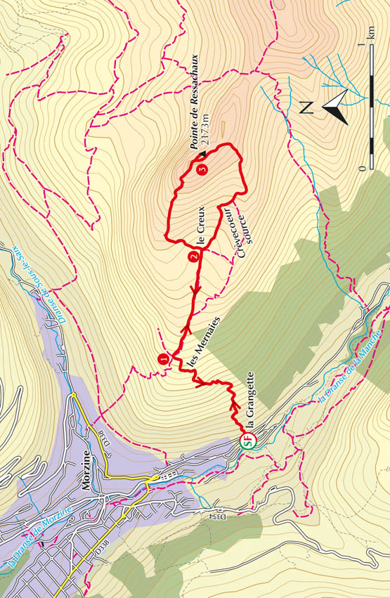
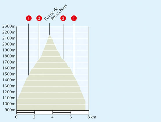
From the signpost ‘la Mernaz’, follow signs ‘Pointe de Ressachaux 2hr 30min/le Creux 1hr 30min’ (this is optimistic). The path is narrow and immediately goes up steeply through tall coniferous and beech trees, with yellow circles to show the way. Keep on the main path, which is well trodden but rocky, with lots of tree roots to negotiate – it is steep all the way. You reach a clearing and vestiges of a chalet called les Mernaies, consisting of a few stone walls and some tumbledown wooden beams. From here the path is less steep for a while, with more open woodland. Keep on the main track, ignoring a red cross on a rock and a narrower path going up right, to reach a crossroads and signpost ‘le Cmon – alt. 1530m’ 1 (1hr).
Turn right towards le Creux, still on the main path (yellow and red marking on a rock and wooden arrows). The path passes a picnic table and a couple of small wooden chalets and comes out into open pastureland, with a good view of the Morzine valley below and the Plénay cable car on the other side of the valley. Continue straight up on a grassy path past another hut called le Plianday, renovated in 2001. The path then goes fairly steeply up through wild raspberry and alder bushes, with the peak of the Ressachaux visible ahead. You can see the long steep shoulder you have to go up, which looks rather daunting. The path takes you to le Creux (1760m) (1hr 40min) 2.

The rustic water trough at le Creux: photo Richard Saynor
In le Creux there are a number of small huts dotted about and an old wooden water trough with a somewhat incongruous stainless steel pipe dispensing delicious cool water. There is a seat here too where you can take a well-earned rest before tackling the second part of the ascent.
At the water trough bear left towards the visible path going up the side of the slope. After skirting round the buildings, the path climbs steeply up through open meadowland and bushes onto the shoulder of the mountain.
In June the slopes are covered with pulsatilla anemones and trumpet gentians, and in high summer there are lots of tall yellow and purple monkshood, feathery purple adenostyles with big green leaves, cornflowers, scabious and astrantia. On the left there is a clear view of the village of Morzine in the valley below.

Ridge before the summit of the Pointe de Ressachaux: photo Philip Jenkins
Now begins the long ascent up the grassy shoulder of the mountain – it seems to go on forever! The path is quite exposed to the elements, with a precipitous drop on the left, but nothing to worry about. Where the path divides about 100 metres before the summit 3, take the left fork up the rocks to the Pointe de Ressachaux (2173m) (3hr).
An imposing granite cross was erected on the summit in 2016. The inscription, in the Savoyard language and French, is a prayer to the ancestors of those living in the valley, who worked hard to provide milk for their families. From here you can clearly see the buildings and ski installations of Morzine-Avoriaz, and further round are the peaks of Hauts Forts, at 2466m the highest in the valley, and Mont Blanc.
Retrace your steps to the fork at 3 and go left on a narrow path which skirts round the mountain below the rocky summit. It then traverses steeply round to the left and descends the shoulder of the southern flank of the mountain. Watch your feet here, as the path may be slippery when wet. From here you can see the path going right down to the huts of le Creux. Continue downwards on the defined path, clearly marked with yellow circles, to reach a wooden signpost (1857m) at the source of the Crèvecoeur stream (3hr 30min).
Follow the rocky streambed down, and then go through alder bushes and vegetation to reach the bottom of the combe by a rock. In autumn, you may detect a whiff of aniseed in the air, which probably emanates from the many fennel plants which grow here. The path continues past scattered huts to reach the water trough at le Creux2.
From here retrace your steps to the crossroads at 1 and bear left, following signs to la Mernaz, back to your car just before la Grangette (5hr 15min).
| Start/Finish | Lac des Mines d’Or, near Morzine, 1390m |
| Distance | 10km |
| Total ascent | 735m |
| Grade | Medium |
| Time | 4hr 30min |
| Maximum altitude | 1990m |
| Map | IGN 3530 ET Samoens Haut-Giffre 1:25,000 |
| Access | From Morzine, follow the signs to Avoriaz at the end of the village and then turn right, indicated Vallée de la Manche/Lac des Mines d’Or/Télépherique Nyon/Charmossière. Go along this narrow road, past the télépherique, until the very end (7km) and park in the car park by the Lac des Mines d’Or. |
| Signposting | Good – new signposts, yellow splashes on the way up and red/white GR5 signs for most of the way down |
This is a delightful walk from a small lake up to two high cols. The Col de Cou is on the border between France and Switzerland, and in former times this was a well-known smugglers’ route between the two countries, and in the Second World War a crossing point for both refugees and partisans. The nearby Col de Bretolet in Switzerland has an ornithological observatory, built in 1958, and both cols are renowned as routes for thousands of migrating birds in spring and autumn. If you do the walk in early autumn, you can watch the ornithologists catching the birds in nets in order to monitor them as they fly south.
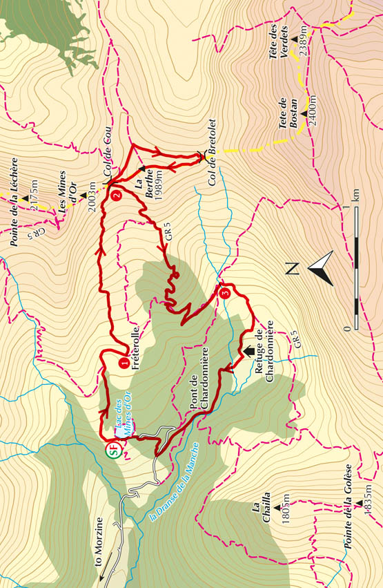
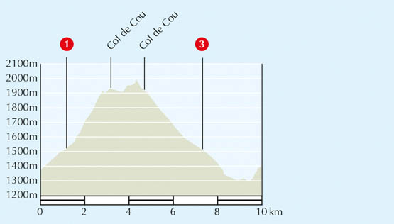
At the Lac des Mines d’Or there is an information board which explains that the lake was artificially created in 1981, and is named after the gold mines higher up the mountain which were dug by the Swiss in 1850. Only a little gold was found and the mines were soon abandoned, with the shafts now blocked by rockfalls. The lake is attractively set in a bowl in the mountains, and there is a pleasant stroll around it taking about 10 minutes. It is now a popular tourist site, with a hotel and restaurant, a children’s play area and donkeys for hire.
From the car park, walk up to a No Entry sign leading onto a wide jeep track through tall fir trees. Follow this for about 15mins to the end of the trees and a signpost ‘le Charnier – alt. 1506m’. Continue straight on, over open grassy slopes, following the signs to Chalets de Fréterolle/Col de Cou until you reach Fréterolle (30min).
At Fréterolle there is a mountain café where you can buy drinks, meals and freshly made cheeses, and an information board on the birds of the region. These include golden eagle, peregrine falcon, black grouse, kestrel, alpine chough, nutcracker, black redstart, wheatear, raven and water pipit.
At the signpost next to this board 1 take the narrow path up to the left, indicating ‘Col de Cou par les Alpages’. (Do not go straight on, indicated ‘Col de Cou par la fôret’.) The path steadily gains height over grassy slopes with cows grazing. Continue upwards over the open slopes towards the col, which you can see ahead of you. You finally reach the Col de Cou (1920m) where there is a small hut which was originally the French-Swiss customs post, a border stone dated 1891 and yellow Swiss signposts 2 (1hr 45min).

Resting on the Col de Cou border stone
At the Col de Cou there is a spectacular view into Switzerland. A panorama board names all the mountains you can see, the most dramatic being the serrated teeth of the Dents du Midi, with the snow-covered Mont Ruan to its right, and les Diablerets to the left; ahead you look down over the ski slopes of Champéry.
To reach the Col de Bretolet, take the path towards Planachaux/Champéry for about 100 metres to a yellow Swiss signpost indicating straight on to Barme/Berroi, and shortly after turn off to the right on an unsigned track. This leads round the back of the ridge to a yellow Swiss signpost headed ‘Alt. 1931m’. You can now see the huts of the observatory ahead, so turn right and walk along the side of the hill, through banks of bilberry and alder bushes, to reach the Col de Bretolet (1936m) (2hr 10min).

Walking towards the Col de Bretolet and the Tête de Bosteon: photo Sharon Bryand
During the migration period in early autumn, nets are strung up to the right and left of the col to catch the birds, and it is interesting to watch the ornithologists as they carefully take the birds out of the nets to be identified, weighed and ringed before being released to continue their journey. Over 20,000 birds of 100 different species are caught here, and it is a sobering thought that of thousands that fly over the pass every autumn, only half survive to make the return journey the following spring. If they are not too busy, the ornithologists will happily talk to you about their task, and you may also find other bird watchers here with their binoculars, hoping to spot a rare species.

Watching migrating birds on the Col de Bretolet
Just before the observatory building, a narrow path bears up to the right alongside the nets (only there in the migration period) and winds up the ridge to reach the highest point at La Berthe (1989m). From here you descend to return to the Col de Cou 2 (2hr 40min).
From the Col de Cou, turn left on the wider track, which is the GR5. Follow the red/white GR markings down to the signpost at Epingly where you continue straight on, following the signs to the Refuge de Chardonnière. This leads down the shoulder of the mountain and enters forest as you zigzag lower. At the signpost ‘Chardonnière – alt. 1600m’, go left, towards Refuge de Chardonnière (3hr 20min). Continue down on a track flanked by bracken and wild rhubarb, through dense pine forest and past a gate, to reach a signpost ‘Torrent de Chardonnière’ on a corner. There is also a noticeboard here with a map showing the Tour des Dents Blanches 3 (3hr 35min).
Go straight on following the GR signs. (Do not take the wider jeep track to the right which is a shorter way back to the lake.) Cross a stream and go through a gate on to another wide track. Further down you emerge into attractive meadowland and come to a sign ‘Plan des Heures – alt. 1460m’. Over on the left is where the GR5 splits off to go to the Refuge de la Golèse. Continue downwards on a jeep track into scattered forest. As you come round a corner, you can see the Refuge de Chardonnière ahead on your left. This is an attractive chalet and a good place for a drink and a rest (3hr 55min).
The Refuge de Chardonnière, www.refuge-chardonniere.fr, has accommodation for 20 in two dormitories, with showers and hot water, and serves meals and drinks. It is open from mid June to mid September.
Turn right towards Pont de Chardonnière and continue down the jeep track. Cross a stream, and then go through tall coniferous trees and a picnic area to reach the Pont de Chardonnière, where there is a large information board. Cross the bridge and follow the signs to le Charny par la Fôret. This is a pleasant walk through trees to reach the road. Cross this to a signpost indicating Lac des Mines d’Or, 10min. This is a fairly steep path in the woods, which leads up to the car park at the Lac des Mines d’Or (4hr 30min).