7 The Chimneys
A long day hike or a backpack to a prominent rock landmark, some petroglyphs, a spring, and Old Maverick Road.
Distance: 15.2 miles out and back
Approximate hiking time: 8 to 9 hours
Elevation: 3,180 to 2,360 feet
Trail surface: Dirt path
Best season: Fall through spring
Water availability: Peña Spring
Land status: National park
Nearest town: Terlingua/Study Butte
Fees and permits: Park entrance fee; permit required for overnight camping
Maps: USGS Cerro Castellan and Castolon; Trails Illustrated Big Bend National Park
Trail contacts: Big Bend National Park, P.O. Box 129, Big Bend National Park 79834; (432) 477-2251
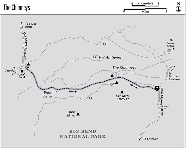
Finding the trailhead: From Big Bend National Park headquarters at Panther Junction, go about 13 miles west on the road to Alpine and Study Butte. Turn left onto Ross Maxwell Drive, the paved road to Santa Elena Canyon and Castolon, and travel about 13 miles to the small parking area on the right (west) side of the road (about 1.3 miles beyond the Burro Mesa turnoff). A small sign marks the Chimneys Trail. The western trailhead is located at the Chimneys West primitive vehicle campsite near Luna’s Jacal on Old Maverick Road.
The Hike
The tall ridge of rock outcrops known as the Chimneys has been a landmark for hundreds of years. Indian petroglyphs decorate one rock wall, and the remains of small rock shelters used by herders are tucked against the rocks. The Chimneys are visible from the trailhead as a long rocky ridge down the long slope to the west. They appear closer than they actually are.
The good trail follows a fairly straight route across the desert flats to the Chimneys. The ridge is in sight for virtually the entire hike. The trail slopes slightly downhill for almost the whole hike, resulting in a long, gentle climb on the return trip. If a shuttle can be set up, it’s easier to do this hike as a one-way from east to west as described.
The Chimneys are 2.4 miles from the trailhead. The petroglyphs are on a wall of the southernmost rock tower. Please don’t disturb or deface them. Be sure to scramble up to the top of the rocky ridge for an endless view of desert and distant mountains.
To continue, keep following the trail west-southwest and slightly downhill from between the main Chimneys ridge and the separate south rock tower with the petroglyphs. The route is less traveled but marked with rock cairns and easy to follow. Eventually the trail drops off the desert flats into a shallow ravine at Peña Spring. A few cottonwoods and willows offer some welcome shade. If rains have been good, a trickle of water may run from the spring down the ravine alongside the trail for about 0.75 mile. Pay attention as the trail crisscrosses the draw until it opens up into a broad, shallow valley.
The trail then curves northwest, crosses the upper part of the valley, climbs over a low saddle north of Peña Mountain, and descends a small draw to the Chimneys West vehicle campsite.
The Chimneys hike is very hot in summer, with very little shade. With a car shuttle, the 7.6-mile one-way hike makes an excellent winter trip. Without a shuttle, the hike to the Chimneys themselves and back is worthwhile. To extend the hike, walk cross-country about 1.5 miles northwest of the Chimneys to Red Ass Spring, marked by a large cottonwood tree.
Miles and Directions
0.0Start at the trailhead on Ross Maxwell Drive.
2.4Reach the Chimneys.
5.3Arrive at Peña Spring.
7.6Reach the Chimneys West campsite trailhead off Old Maverick Road. Unless you’ve arranged a car shuttle, retrace your steps.
15.2Arrive back at the trailhead.