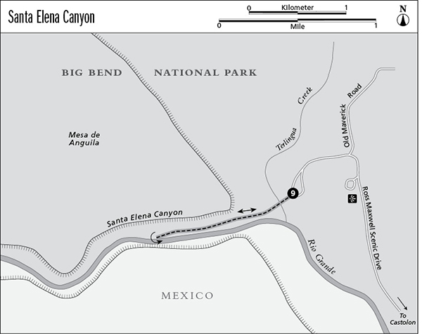
9 Santa Elena Canyon
A day hike into the dramatic, narrow, 1,500-foot-deep mouth of one of the main canyons of the Rio Grande.
Distance: 1.6 miles out and back
Approximate hiking time: 1 hour
Elevation: 2,160 to 2,240 feet
Trail surface: Dirt path, sandy wash
Best season: Fall through spring
Water availability: None; see hike description
Land status: National park
Nearest town: Terlingua/Study Butte
Fees and permits: Park entrance fee
Maps: USGS Castolon; Trails Illustrated Big Bend National Park
Trail contacts: Big Bend National Park, P.O. Box 129, Big Bend National Park 79834; (432) 477-2251
Finding the trailhead: From park headquarters at Panther Junction, go west on the Alpine road about 13 miles to the Castolon and Santa Elena junction. Turn left (south) onto Ross Maxwell Scenic Drive and go about 30 miles to the end of the paved road at the Santa Elena Canyon parking area.
The Hike
Santa Elena Canyon is the first of three major canyons cut by the Rio Grande in Big Bend National Park. The narrow, 7-mile-long canyon slices through the thick limestone layers of the Mesa de Anguila. The canyon walls rise in sheer cliffs as much as 1,500 feet from the river to the rim above. Peregrine falcons nest in impossible aeries high above the muddy Rio Grande. When river levels are high enough, canoeists and rafters float Santa Elena Canyon more than any other stretch of the Rio Grande in the park. Unfortunately, drought and Mexico’s failure to release water required by treaty has often meant very low flow levels in recent years. The canyon ends abruptly at the mouth, across from the parking area.
Follow the popular trail from the parking lot through a dense thicket of cane, mesquite, willow, and tamarisk to the confluence of Terlingua Creek and the Rio Grande. Depending on rainfall and the amount of gravel deposited at the confluence, you may have to wade across Terlingua Creek to continue the hike up into the canyon. If the creek is flowing deep or fast, wait until another day to complete the hike.
Across the creek the trail switchbacks about 80 feet up a rocky bluff into the canyon before slowly descending back to the riverbank. The trail winds through house-size boulders and dense thickets of cane before ending where the river cuts off the riverbank at the canyon wall.
This hike is very hot in summer, but except at midday the canyon walls and cane thickets provide good shade. It’s best to make this hike early in the morning in summer. As tempting as it may look, be wary about swimming in the Rio Grande. As the river hisses by with no rapids, it appears inviting on hot days. However, its placid appearance belies considerable depth and strong currents.
Plan to carry water for your hike; river and creek water is marginal even with purification. Keep an eye on the weather, especially in late summer. If Terlingua Creek floods, you will be trapped in the canyon.
Miles and Directions
0.0Start at the trailhead from the Santa Elena Canyon parking area.
0.8Reach the end of the trail where the river cuts off the riverbank. Retrace your steps.
1.6Arrive back at trailhead.