11 Rosillos Peak
This long cross-country day hike will lead to excellent views and solitude atop the Rosillos Mountains.
Distance: Approximately 12.0 miles out and back
Approximate hiking time: 9 to 12 hours
Elevation: 3,040 to 5,445 feet
Trail surface: Cross country route on steep, rocky slopes
Best season: October through March
Water availability: Alamo and Lost Springs (Unreliable; see text.)
Land status: National park
Nearest town: Terlingua/Study Butte
Fees and permits: Park entrance fee
Maps: USGS Twin Peaks and Bone Spring; Trails Illustrated Big Bend National Park
Trail contacts: Big Bend National Park, P.O. Box 129, Big Bend National Park 79834; (432) 477-2251
Finding the trailhead: From park headquarters at Panther Junction, drive north toward Marathon about 22.7 miles to the dirt road turnoff on the left. (Or drive 4.2 miles south from the Persimmon Gap Visitor Center on the same park road.) The junction is marked with signs for Terlingua Ranch and other destinations.
Terlingua Ranch Road is a county road, but its condition varies tremendously. During and after the rainy season are usually the worst times to visit. Mud and washouts can make the road virtually impassable to any vehicle. Sand is usually the problem the rest of the year. Experienced drivers can sometimes make the drive with a sedan, but a high-clearance or four-wheel-drive vehicle is probably a better bet. Use great care crossing the long sandy stretches. Check with park rangers about the road’s condition before attempting it.
Follow Terlingua Ranch Road, the main county road, about 14.2 miles to an old road forking off to the left. The old road, which looks more like a dry wash, is now closed and marked with a road closed sign. Park at the turnoff. If you miss the old road, keep driving until you reach the well-marked fenced and signed park boundary at about 15.1 miles. Turn around and carefully retrace your route a bit less than 1 mile to the old road.
The Hike
The Rosillos Mountains were given to the National Park Service by The Nature Conservancy. Houston and Ed Harte of San Antonio donated the 67,000-acre ranch to the conservancy in 1984. At the time, it was the conservancy’s largest preserve in the United States.
The mountains were formed by a large granite laccolith. Although the mountains are not high in an absolute sense, they do rise an impressive 2,600 feet about the surrounding desert. A few small springs lie tucked away in hidden canyons, providing water for wildlife in the otherwise dry and desolate mountain range.
The hike to the summit of Rosillos Peak should be attempted only by fit, experienced hikers and only in the cooler part of the year. At least one member of the party must be good at route-finding. There is no trail; the route follows rocky canyon bottoms and steep, cactus-covered slopes. Heavy boots, long pants, the USGS topo maps, a compass, and lots of water are necessities for this hike. The Trails Illustrated map is not adequate and in fact contains some significant errors in the Rosillos Mountains. Do not depend on it. The roads are out of date on the topo map, so you must have a route-finding expert with your hiking party. Although heat is usually the problem at Big Bend, occasional winter storms can bring frigid temperatures to the bare mountains.
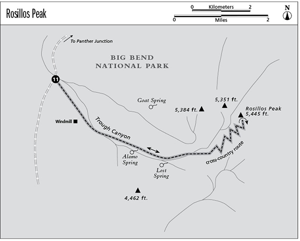
Follow the old road southeast toward the mountains. You’ll pass an old windmill at the mouth of Trough Canyon. After the old road ends, follow the wash up into the canyon. Alamo Spring is located in the canyon bottom about 1.0 mile up the canyon. Lost Spring lies in the bottom where the canyon forks. Stay left in the main fork as it turns left (northeast). Do not depend on water from the springs without checking with the Park Service ahead of time. Plan to carry plenty with you.
The park boundary lies on the ridge above Trough Canyon on the south side. Do not cross the fenced and marked boundary; the land on the other side is private.
After you turn northeast in the main canyon fork, begin to climb up the right (east) wall of the canyon to the ridgetop. Follow the ridgetop to the northeast, keeping Trough Canyon down below to your left. The ridge steepens as you climb toward the summit. Be sure to stay within the park boundary fence. Finally the grade moderates as you reach a summit below the main peak. A short walk across an easy saddle to the north-northeast will bring you to the main summit.
Surprisingly, the top of the mountain is quite grassy, with even a few hardy junipers here and there. Views stretch for miles, from the Big Bend country of Texas far into Mexico. Other than a road or two, few signs of man are visible.
The park doesn’t allow backcountry camping in the Rosillos Mountains, so plan on a long day. In winter, probably the best time for the hike, the days are short. Get an early start; you will probably need every bit of daylight there is for the round-trip.
If you make it to the summit, be proud; very few others have. Return via the same route; or using the maps and compass, pick an alternate descent back to the trailhead.
Miles and Directions
0.0Start at the trailhead on Terlingua Ranch Road.
1.5Old windmill site.
2.5Alamo Spring.
3.75Lost Spring.
6.0Reach the summit of Rosillos Peak. Retrace your steps.
12.0Arrive back at the trailhead.