
Rancherías Canyon cuts deep into the Bofecillos Mountains.
12 Rancherías Canyon
A day hike through a rugged desert canyon in the Bofecillos Mountains to an 80-foot seasonal waterfall.
Distance: 9.6 miles out and back
Approximate hiking time: 5 hours
Elevation: 2,500 to 3,360 feet
Trail surface: Dirt path; sand, gravel, and cobbles of canyon bottom
Best season: Fall through spring
Water availability: Unreliable (See text.)
Land status: State park
Nearest town: Lajitas
Fees and permits: Park entrance fee; additional fee for camping
Maps: USGS Redford SE and Agua Adentro; Big Bend Ranch State Park Backcountry and River Guide
Trail contacts: Big Bend Ranch State Park, P.O. Box 2319, Presidio 79845; (432) 229-3416
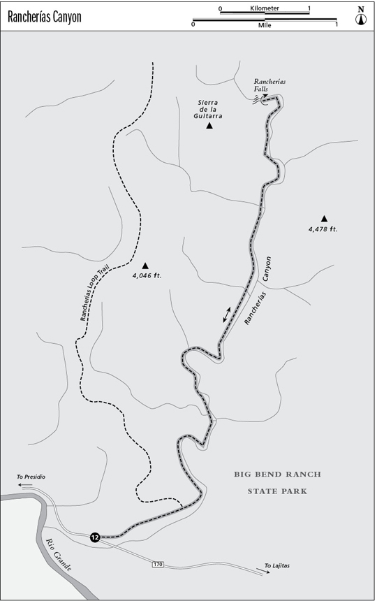
Finding the trailhead: From the center of Lajitas, drive west on FM 170 about 22.2 miles to the well-marked West Rancherías trailhead on the right. From Fort Leaton State Historic Site in Presidio, drive 27 miles east on FM 170 to the trailhead. Be sure to get a park permit at the trailhead or at the Barton Warnock Center in Lajitas before making this hike.
The Hike
Big Bend Ranch, with about 299,000 acres, was purchased in 1988 by the state and is managed as a state park by the Texas Parks and Wildlife Department. The desert park extends from the craggy heights of the Bofecillos Mountains down to the deep canyons of the Rio Grande on the Mexican border. FM 170 crosses the southern edge of Big Bend Ranch along the river. The route, possibly the most scenic drive in Texas, traverses a twisted and tortured desert landscape of ancient lava flows and water-cut canyons.
Big Bend Ranch is largely undeveloped. This hike, although generally easy to follow, starts with a short section of trail and old road but quickly changes into a canyon-bottom hike marked with occasional cairns. It follows a canyon into the heart of the Bofecillos Mountains on relatively easy terrain. Hikers with some experience should have little trouble following the route. Don’t let the bleak appearance of the terrain at the trailhead discourage you. Rancherías Canyon is a hidden jewel, unknown to most people.
The trail starts at the right side of the parking area. The path, marked with rock cairns, drops immediately into a small desert wash. It follows the sandy bottom of the wash, paralleling the highway, a short distance before climbing out onto an old unused four-wheel-drive road. Turn left onto the old road and follow it up toward the mountains away from the highway. After about 0.5 mile the road forks at some large rock cairns. Take the right fork and drop down into the canyon bottom. The left fork is part of the long Rancherías Loop Trail. The old road ends at the canyon bottom.
Rancherías Canyon cuts deep into the Bofecillos Mountains.
The rest of the hike is easy to follow. Just walk up the main canyon into the mountains. Depending on rainfall, parts of the canyon will have a small flowing stream. At about 2.0 miles the trail enters the spectacular high-walled part of the canyon. Old lava flows from the Bofecillos and Sierra Rica Volcanos form the sheer walls. Cliffs and occasional cottonwoods, willows, and tamarisks provide shady rest areas on hot afternoons. The canyon climbs at a gradual, easy grade all the way to the end of the hike. Although the route is not an improved trail, much of it follows a smooth sand-and-gravel surface. Occasional rocky areas slow the pace some.
The hike ends after a narrow sheer-walled bend in the canyon at 80-foot high Rancherías Falls. Cliffs make it dangerous to climb around the pour-off, so the park recommends that you don’t try. If you do the hike after a good late-summer rainy season, you may be lucky enough to see the pour-off as a flowing waterfall. Return to the trailhead by the same route. If you miss the old road, don’t worry. The canyon crosses the highway just east of the trailhead.
This can be an extremely hot hike from April to October. It’s not uncommon for summer temperatures to reach 110 degrees along the river in summer. Try to hike during cooler parts of the year. The water in the canyon is not reliable, so plan to carry plenty for this long a trip. Most of the hike follows the canyon bottom, so watch the weather. Flash floods can roar down from the mountains above. Don’t leave anything of value (or ideally, anything at all) in your car. You may wish to arrange a car shuttle with one of the outfitters in Lajitas or Terlingua, especially for an extended trip, if you don’t want to leave your car unattended.
If you like this hike, consider trying the much longer Rancherías Loop Trail. The loop circles deep into the rugged backcountry of the Bofecillos Mountains, traversing rugged canyons and passing springs and historic sites. The loop usually requires two to three days to complete.
Miles and Directions
0.0Start at the West Rancherías Trailhead on FM 170.
0.75Fork in old road. Go right, drop into the canyon bottom and follow it upstream.
2.0The trail enters the high-walled section of the canyon.
4.8Reach Rancherías Falls, your turnaround point.
9.6Arrive back at the trailhead.