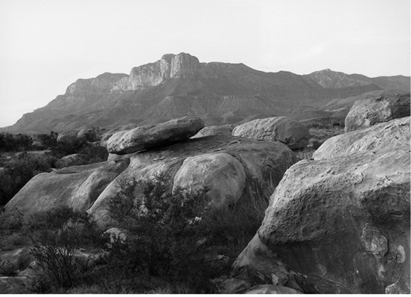
The Guadalupe Mountains rise almost a vertical mile above the desert floor.
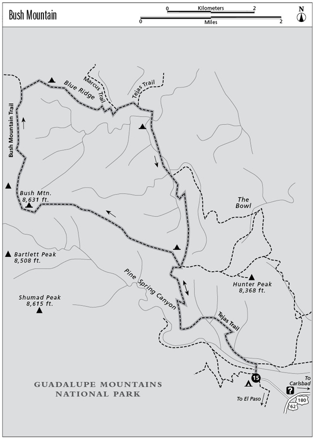
15 Bush Mountain
A two- or three-day hike to the second-highest point in Texas, with cool mountain forests and tremendous views.
Distance: 17.1-mile lollipop
Approximate hiking time: 2 to 3 days
Elevation: 5,820 to 8,631 feet
Trail surface: Dirt, gravel, and rock path
Best season: Year-round
Water availability: Trailhead (at the restroom)
Land status: National park
Nearest town: Carlsbad, New Mexico
Fees and permits: Park entrance fee; permit required for camping
Maps: USGS Guadalupe Peak and PX Flat; Trails Illustrated Guadalupe Mountains National Park; National Park Service brochure
Trail contacts: Guadalupe Mountains National Park, 400 Pine Canyon Road, Salt Flat 79847; (915) 828-3251
Finding the trailhead: From the main park visitor center just off US 62–180, drive up the paved road to the Pine Springs Campground, about 0.5 mile northwest. Park in front of the large trailhead sign at the far side of the RV camping area.
The Hike
This hike follows a loop through some of the most scenic high country in Texas. Endless views are interspersed with dense forests of pine and fir. The longest stretch of trail in Texas above 8,000 feet lies along this route.
As with all high-country hikes in the Guadalupes, lack of water is a problem. Plan to carry all that you need. The trail starts from the Pine Springs Campground and hits two junctions very soon after starting. Following the signs for the Tejas Trail, go right at the first junction and left at the second.
The trail climbs slowly up the wall of Pine Spring Canyon at a steady but generally moderate grade. As with most Guadalupe trails, it tends to be rocky, even though relatively well maintained. The 3.8-mile climb to the crest is on the unshaded south-facing slope of the canyon—it tends to be hot most of the year. Try to get a very early start, especially in summer.
Take a break and get your heart rate down when you finally top out. The worst of the climb is over. In sharp contrast to the desert slopes you just climbed, the mountaintops to the north are clad with scattered groves of ponderosa and southwestern white pine, Douglas fir, and alligator juniper.
The trail forks three ways at the crest. Go left, off the Tejas Trail, toward Bush Mountain. The trail follows the north rim of Pine Spring Canyon to the summit of Bush Mountain, the second-highest peak in Texas. The ups and downs along the way get a little tiring but aren’t nearly as bad as the climb up out of Pine Spring Canyon.
The Guadalupe Mountains rise almost a vertical mile above the desert floor.
Unlike most of the other peaks in the Guadalupes, Bush Mountain has a large, relatively flat, partly wooded summit. Views to the west, down the sheer western escarpment, are spectacular, with a drop of almost one vertical mile. To the south, topping the abrupt escarpment, loom Bartlett, Shumard, and Guadalupe Peaks—the other three of the four highest peaks in Texas. Many years ago, in a fit of adolescent frenzy, I climbed all four peaks in one day. With no trail and many thousands of feet of elevation gain and loss, I recommend this feat only to masochists.
From Bush Mountain the trail continues north along the western escarpment for about 2.0 miles to a junction. Be sure to watch the sunset from somewhere along here if you camp at one of the Bush Mountain or Blue Ridge campsites. At the junction go right (east), away from the escarpment. If you have time and enough water, you can lengthen the loop by going left. This route will take you into some of the least-visited areas of the park.
After the fork the trail follows Blue Ridge for over a mile before dropping down to the Marcus Trail junction. Stay right, toward the Tejas Trail. In about 0.3 mile the trail intersects the Tejas Trail. Go right, back toward Pine Springs Campground, on the Tejas Trail. The trail drops into a lushly wooded canyon and gradually follows it upstream. Ignore the left fork that heads to the Bowl, about 1.0 mile up the canyon. After about 2.5 miles the trail meets the junction at the start of the loop. From there, just follow the same trail back down into Pine Spring Canyon to the campground.
Camping is allowed only at designated campsites. For a one-night trip, the best campsites would probably be at either Bush Mountain or Blue Ridge, depending on how hard you want to push on the first day. For a two-night trip, a good choice would be Bush Mountain on the first night and Tejas on the second night.
The high country is very pleasant in summer, although the climb out of Pine Spring Canyon will be hot. Spring has notorious winds at times. Winter is generally good, but check weather forecasts. The Guadalupes are high enough to get a few winter storms and even heavy snow on occasion. Snow usually melts off quickly, however. Fall is probably my favorite time in the Guadalupes. You’ll have the high country almost to yourself, while the crowds jam McKittrick Canyon. Maples grow along the route, especially on the return leg of the loop in the wooded canyon bottom. Even a few aspens survive in the high country if you know where to look.
Miles and Directions
0.0Start at the trailhead at Pine Springs Campground. Go right at the first fork reached, in about 100 feet. At the second junction go left, following the signs for the Tejas Trail.
3.8Three-way junction on canyon rim. Go left toward Bush Mountain.
6.5Reach Bush Mountain.
8.7Trail junction at Blue Ridge. Go right on Blue Ridge Trail.
10.4Marcus Trail junction. Go right.
10.7Tejas Trail junction. Go right on Tejas Trail.
11.8Trail junction. Go right to stay on Tejas Trail.
13.3Three-way junction on the canyon rim. Take the middle fork and retrace your earlier route back down into Pine Spring Canyon and past the final two junctions right before the trailhead.
17.1Arrive back at the trailhead.