The permanent stream in McKittrick Canyon hosts the only reproducing trout population in Texas.
17 McKittrick Canyon
A day hike into rugged McKittrick Canyon, famous for its fall color and mountain stream.
Distance: 6.8 miles out and back
Approximate hiking time: 3 to 4 hours
Elevation: 4,980 to 5,320 feet
Trail surface: Dirt and gravel path
Best season: Year-round
Water availability: Trailhead, McKittrick Creek
Land status: National park
Nearest town: Carlsbad, New Mexico
Fees and permits: Park entrance fee
Maps: USGS Guadalupe Peak and Independence Spring; Trails Illustrated Guadalupe Mountains National Park; National Park Service brochure
Trail contacts: Guadalupe Mountains National Park, 400 Pine Canyon Road, Salt Flat 79847; (915) 828-3251
Finding the trailhead: From the main park visitor center, drive northeast toward Carlsbad on US 62-180 for about 8 miles to the marked McKittrick Canyon junction. Turn left toward the mountains on the paved road and follow it about 4 miles to its end at the McKittrick Canyon Visitor Center.
The Hike
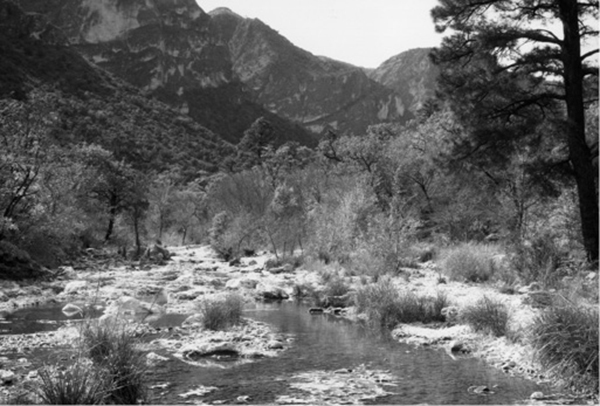
McKittrick Canyon is one of the most famous scenic spots in Texas. The canyon mouth conceals its secrets well. The dry desert slopes give little sign of the lush vegetation and rushing stream found hidden in the canyon. McKittrick is particularly famous for its large stands of bigtooth maples. In the fall, some parts of the canyon resemble New England more than West Texas. If you do come in autumn, try to avoid the weekends—heavy crowds descend on the canyon during fall color. In fact, the park limits the number of people allowed in the canyon on fall weekends. Because the canyon is very delicate and so many people visit, be sure to stay on the trail to avoid trampling the vegetation.
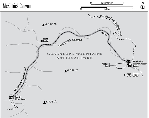
During the rest of the year, the canyon is relatively quiet. The trail starts on the other side of the visitor center. Be sure to sign the register. Ignoring the Nature Trail loop on the left and the Permian Reef Geology Trail on the right, continue straight ahead into the canyon. The trail quickly drops into the canyon and crosses to the other side of the wash. The trail follows what used to be a road up to Wallace Pratt’s old lodge. It follows the benches above the wash and makes occasional crossings. The third crossing contains a surprise—a clear stream that flows down-canyon except in very dry times.
The stream is the only place in Texas with a reproducing population of trout. Scientists are unsure whether the trout are native, stocked, or a cross between the two. Because of the small population, fishing isn’t allowed. On hot days, resist the temptation to wade in the stream. With the heavy visitation, waders would quickly pollute the stream. Be sure to purify the water before drinking.
The permanent stream in McKittrick Canyon hosts the only reproducing trout population in Texas.
The next stream crossing is also wet, but the rest of the crossings to the Pratt house are dry. Apparently the deep gravels in that part of the canyon absorb the stream’s flow. At about 2.3 miles, at a large canyon junction, you will encounter a picnic area and a trail junction. The right fork goes only 200 feet or so up to the Pratt house, well hidden in the woods. The interesting house is made almost entirely of stone, even the roof. A park ranger is often stationed there.
The trail continues up the south fork of the canyon from the picnic area. The stream soon reappears. Much of the trail passes through woods consisting of ponderosa pine, alligator juniper, oaks, ash, and large stands of maples. At a little more than 3.0 miles, the trail forks. The right fork begins to climb up out of the canyon to the canyon rim. Go left to the Grotto Picnic Area. At about 3.4 miles the trail comes into the picnic area, a shaded site tucked up against a cliff with several small caves. Just a bit farther up the canyon, the trail ends at the old stone line camp. Please don’t disturb the old building.
Because of its delicate nature, the canyon beyond the line camp has been designated a research natural area and is closed to visitation. To extend your hike, take the right fork at the junction just before the picnic area. It climbs up out of the canyon into the high country. The trail can be followed all the way to the Bowl, Bush Mountain, Lost Peak, and other area destinations. To camp at McKittrick you must climb up to the designated sites in the high country. No camping is allowed in the canyon itself.
Be sure to note the times that the gate is open at the McKittrick turnoff on US 62-180. Unless you have obtained a camping permit for the high country, you must leave the canyon in time to reach the gate by closing time.
Miles and Directions
0.0Start at the trailhead at McKittrick Canyon Visitor Center.
2.3Pratt Lodge.
3.3Trail junction. Go left.
3.4Reach the Grotto Picnic Area and line camp. Retrace your steps.
6.8Arrive back at the trailhead.