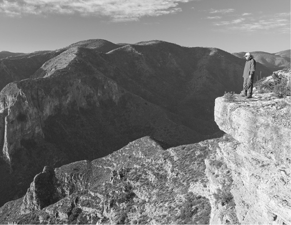
A hiker looks down into the depths of South McKittrick Canyon from near the McKittrick Ridge campsite.
22 McKittrick Ridge
An overnight hike through the best fall color and some of the most rugged terrain in Texas.
Distance: 14.9 miles one-way with car shuttle (29.8 miles out and back)
Approximate hiking time: 2 days
Elevation: 4,980 to 7,900 feet
Trail surface: Dirt path
Best season: Year-round
Water availability: Dog Canyon and McKittrick Canyon trailheads; McKittrick Creek toward end of hike
Land status: National park
Nearest town: Carlsbad, New Mexico
Fees and permits: Park entrance fee; permit required for camping
Maps: USGS Guadalupe Peak and Independence Spring; Trails Illustrated Guadalupe Mountains National Park; National Park Service brochure
Trail contacts: Guadalupe Mountains National Park, 400 Pine Canyon Road, Salt Flat 79847; (915) 828-3251
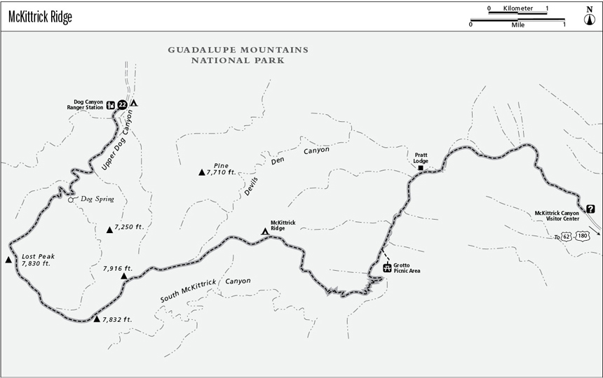
Finding the trailhead: The trailhead is most easily approached from New Mexico. Drive about 12 miles northwest of Carlsbad on US 285 to the New Mexico 137 junction. Turn left (southwest) and follow paved NM 137 up into the mountains. At about 45 miles the road drops abruptly down to the big valley of Dog Canyon. In the bottom of the valley, the road forks after passing through the short canyon known as El Paso Gap. Go left, following signs to the national park. At about 6 miles the road crosses into Texas and the park and the pavement becomes a good gravel surface. Just beyond, at the end of the road, lie the Dog Canyon Ranger Station, campground, and trailhead. A long, dusty alternate route is possible by coming via Dell City, Texas.
To set up a car shuttle, from the main park visitor center, drive northeast toward Carlsbad on US 62-180 for about 8 miles to the marked McKittrick Canyon junction. Turn left toward the mountains on the paved road and follow it about 4 miles to its end at the McKittrick Canyon Visitor Center. Leave your shuttle vehicle here.
The Hike
Although the car shuttle is lengthy, the round-trip length of this hike, plus the lack of water in the high country between, makes a shuttle highly recommended. The only water on the hike is found in the bottom of McKittrick Canyon, necessitating a very long, steep climb back up to the McKittrick Ridge campsite with a pack full of water if a round-trip hike is done. Because the Dog Canyon trailhead is more than 1,200 feet higher the McKittrick Canyon trailhead, it is much easier to start the hike at Dog Canyon.
Guadalupe Mountains National Park does not receive heavy tourist traffic as a whole, but because of its remote location, Dog Canyon receives even less visitation than the rest of the park. The large valley of Dog Canyon narrows abruptly at the state line and forms a well-defined canyon at the trailhead. The small, shady campground near the trailhead is an excellent place to spend the night before or after the hike.
As with all high-country hikes in the Guadalupes, there are no water sources up high, so you must carry all you need. The upper part of the hike is very exposed to lightning, especially on late-summer afternoons. Check weather forecasts in winter before you hike. Snowstorms aren’t common, but they can be sudden and powerful. If a front is forecast during your hike, consider waiting until it has passed. The strong winds from such weather can make hikes in the Guadalupes really miserable. This is a good summer hike, but start very early in the morning to avoid the heat during the climb.
The Bush Mountain Trail forks to the right just after the start of the hike. Stay left on the Tejas Trail and continue up the main canyon through patchy woods of juniper, piñon pine, velvet ash, bigtooth maple, and scattered ponderosa pine. The maples turn brilliant gold and scarlet in the fall, probably the best time for this hike.
A hiker looks down into the depths of South McKittrick Canyon from near the McKittrick Ridge campsite.
At roughly 1.5 miles the trail leaves the canyon bottom and begins climbing in earnest. Dog Spring lies just up the canyon from where the trail begins its climb out. Check at the ranger station about its status before depending on it. Since the spring is so close to the trailhead, it’s easier to fill up at the start and not have to worry about collecting and purifying the springwater.
Although it’s not obvious, the trail passes an old mining area on the right partway up the ridge. Scattered mostly on the west side of the ridge out of sight lie several small copper mines. The long-abandoned mines were unsuccessful, not surprising in the poorly mineralized Guadalupes. Don’t try to enter the hazardous gated tunnels or disturb any of the ruins.
From the old mines, the trail continues a long, steady climb up to the ridge right below Lost Peak. The trail passes through scattered patches of stunted ponderosa pine and other trees. The grade eases when you reach the rim of West Dog Canyon below Lost Peak. The worst of the climbing is over. In fall, good color lines the canyon bottom and slopes below. The spectacular view stretches from the tallest peaks of the Guadalupes to the south to the much higher Sacramento and Capitan Mountains far to the north in New Mexico.
Continue with some mild climbing on the Tejas Trail for less than 1.0 mile to the junction with the McKittrick Canyon Trail. Go left on the much-less-traveled McKittrick Trail. The trail winds along the rim of sheer-walled chasm of South McKittrick Canyon for 3.5 miles to the McKittrick Ridge primitive campsite. There are some mild ups and downs as the trail winds along the rim, but in general this part of the hike is easy and enjoyable. Sometimes the trail is in the open, overlooking the canyon. Other times it winds through woods of ponderosa pine, Douglas fir, southwestern white pine, oak, and maple. The tent pads at the pleasant campsite lie a short distance off the trail in thick woods, which give at least some protection from the notorious winds that can sometimes rake these mountains.
About 0.5 mile past the campsite, the trail begins the steep descent into South McKittrick Canyon, losing about 2,800 feet by the time it reaches the McKittrick trailhead. About 2,300 feet of that is lost between the campsite and the Grotto Picnic Area in the canyon bottom. While the trail is steep, the views into the incredibly rugged depths of the canyon are unsurpassed in Texas. Eventually, after many switchbacks the trail reaches the canyon bottom at the junction with the short spur trail to the picnic area and old line camp. Take a break there before continuing down the canyon. This part of McKittrick offers the best fall color in the state in late October/early November. Enjoy the easy 1.1-mile stroll down the canyon to the Pratt Lodge. From there it’s another easy 2.3 miles down the increasingly desertlike canyon to the McKittrick Canyon visitor center and trailhead.
Miles and Directions
0.0Start at the Dog Canyon trailhead.
0.1Junction with the Bush Mountain Trail. Go left on Tejas Trail.
1.5Trail passes near Dog Spring.
4.0Junction with McKittrick Canyon Trail. Go left.
7.5McKittrick Ridge campsite.
11.5Grotto Picnic Area in South McKittrick Canyon bottom.
12.6Pratt Lodge.
14.9McKittrick Canyon Visitor Center, trailhead, and your shuttle vehicle. (Option: If you haven’t arranged for a shuttle, retrace your steps for a 29.8-mile out-and-back hike.)