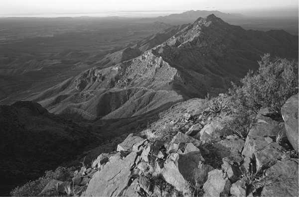
Anthony’s Nose and the distant Organ Mountains can be seen from North Mount Franklin.
23 North Mount Franklin
A day hike to spectacular views from the highest peak in the Franklin Mountains.
Distance: 9.2 miles out and back
Approximate hiking time: 6 to 8 hours
Elevation: 4,820 to 7,192 feet
Trail surface: Old closed four-wheel-drive road, dirt path
Best season: Fall through spring
Water availability: None
Land status: State park
Nearest town: El Paso
Fees and permits: Park entrance fee
Maps: USGS North Franklin Mountain and Canutillo
Trail contacts: Franklin Mountains State Park, 1331 McKelligon Canyon Road, El Paso 79930; (915) 566-6441
Finding the trailhead: From downtown El Paso follow I-10 west to the Trans-Mountain Highway (Loop 375) exit on the west side of the city. Follow the Trans-Mountain Highway east toward the mountains for about 3.4 miles to the turnoff on the left into Franklin Mountains State Park. Follow the road into the Tom Mays picnic area for about 0.9 mile to a short side road on the right. Follow this road a short distance to its end at the trailhead.
The Hike
El Paso surrounds the craggy north–south range of the Franklin Mountains on three sides. The range is not especially large or high, but its 3,400-foot rise above the Rio Grande Valley gives it an impressive profile. Except for cottonwoods, ashes, and hackberries hidden away at a few springs, the mountains are cloaked entirely in Chihuahuan Desert vegetation. Franklin Mountains State Park comprises more than 24,000 acres, making it the third-largest state park in Texas and one of the largest urban parks in the country. Almost the entire range lies within the park, creating a small wilderness surrounded by more than 1.5 million residents in El Paso and Juarez.
The trail follows a rough dirt road, closed to vehicles, from the trailhead east toward the mountains. The trail follows the old dirt road all the way to the summit. Mountain bikes are allowed on the trail up to Mundy’s Gap and down the other side. The road was built in the 1970s by a developer. His actions and other encroaching development were the major stimuli for the creation of the park.
The old road climbs gradually into a small canyon but quickly begins to switchback up the slopes at a moderate grade. Just before the old road climbs up out of the canyon, a side trail forks right and leads to West Cottonwood Spring—a small, shady oasis at the end of the short side trail. About halfway up the peak, the road crests the range at a large pass, Mundy’s Gap. The road descends a short distance down the other side before coming to a junction. Mountain bikes can go this far and on down the left fork of the old road. Take the road to the right and resume climbing. The road steadily climbs higher, reaching a small saddle partway up. A short side trip to the east from the saddle will take you to Indian Peak, the small peak with an old military building visible on its summit. Continue up a series of switchbacks to reach the summit of North Mount Franklin.
Anthony’s Nose and the distant Organ Mountains can be seen from North Mount Franklin.
The 360-degree views from the summit are spectacular. El Paso and Juarez stretch in three directions from the foot of the mountains. To the north lie high New Mexico ranges, such as the Organ Mountains, Sierra Blanca, and the Black Range. The Rio Grande forms an emerald ribbon to the west as it flows to the sea.
The peak can be climbed any time of year but offers little shelter from the sun or any kind of bad weather. If you hike in summer, get a very early start to avoid the heat. In late summer, afternoon thunderstorms can pummel the mountains. Spring days can be windy. Winter usually provides excellent hiking weather, but occasional snows fall on the mountains. I was caught just below the summit by a crazy mix of lightning, snow, hail, and rain in early May one year. I quickly discovered that the higher slopes offer little cover.
The dated USGS map shows only the natural features, not the old road used as the route. Check with a ranger before hiking to see if any improved maps are available. However, it’s an easy route to follow.
Unless you have reserved a campsite, Tom Mays Picnic Area is open only for day use. Make sure you get back to your car before they lock the gate at night. Check on the current hours before starting the hike.

Miles and Directions
0.0Start at the trailhead near the picnic area.
2.75Mundy’s Gap.
3.0Old road junction. Go right, up the mountain.
4.6Reach the North Mount Franklin summit.
9.2Arrive back at the trailhead.