24 Anthony’s Nose
A cross-country day hike to the rugged summit of the second-highest peak in the Franklin Mountains.
Distance: 10.0 miles out and back
Approximate hiking time: 8 to 10 hours
Elevation: 4,600 to 6,927 feet
Trail surface: Old closed dirt road, rugged cross-country route
Best season: Fall through spring
Water availability: None
Land status: State park
Nearest town: El Paso
Fees and permits: Park entrance fee
Maps: USGS North Franklin Mountain and Canutillo
Trail contacts: Franklin Mountains State Park, 1331 McKelligon Canyon Road, El Paso 79930; (915) 566-6441
Finding the trailhead: From downtown El Paso follow I-10 west to the Trans-Mountain Highway (Loop 375) exit on the west side of the city. Follow the Trans-Mountain Highway east toward the mountains for about 3.4 miles to the turnoff on the left into Franklin Mountains State Park. Follow the road into the Tom Mays Picnic Area for about 2 miles to the most northerly picnic tables on a hill at the end of the paved park road.
The Hike
The Franklin Mountains are a rugged desert mountain range that comprises the jagged spine of the sprawling city of El Paso. The city forms a horseshoe shape around the south end of the range, but the mountains themselves are relatively empty and undisturbed. After a developer began carving roads on the slopes, the state purchased the property for a state park. With more than 24,000 acres, the park is one of the largest in Texas and encompasses most of the small range.
The dry mountains are vegetated by Chihuahuan Desert plants such as sotol, lechuguilla, prickly pear, and yucca. One oddity, the large barrel cactus of the Sonoran Desert of Arizona, finds the easternmost limit of its range in the Franklins. Unfortunately poachers have stolen many of the cacti.
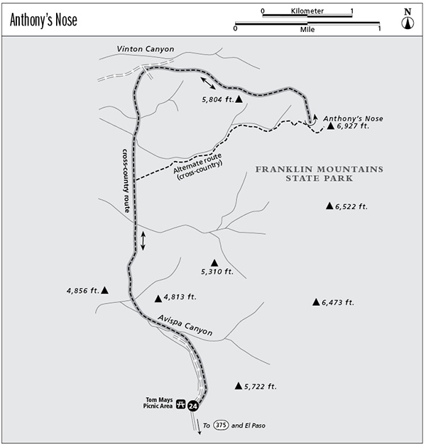
Anthony’s Nose is the second-highest peak in the Franklins. If you’re curious about the peak’s name, just look at its profile as you drive by the mountains on I-10 to the west. No developed trail climbs to the summit of Anthony’s Nose. The hike is an unmarked, rugged cross-country scramble up steep slopes covered with cacti and other spiny plants. Only fit, very experienced hikers who are good at map reading and route-finding should attempt the ascent. Sheer cliffs require frequent detours. Not only is the hike long, but it ascends 2,300 feet. The hike is very hot in summer, with little shade. Winter is usually good, but go prepared for the occasional winter storm. Such storms can drop the temperature far below freezing and even dump occasional snows. Get an early start in winter, since the days are short and you will probably need all day for this hike. Hikers need to obtain the relevant topographic maps before doing the climb. The map provided in this guide is not sufficient by itself for this hike. A trekking pole might be useful for maintaining balance on the steep cross-country sections of the hike.
For the most part, you will have to pick your own route up. This description covers only one possible way to the summit. From the picnic area, drop down into an arm of Avispa Canyon. Follow an old closed dirt road down into the main part of the canyon. About 1.0 mile down the canyon from the start, turn north and climb up out of the canyon between the two hills marked with the elevations “4,856” and “4,813” on both the topo map and this guidebook’s map.
Hike north along the base of the mountains for about 2.0 miles until you hit the dirt road that goes up into Vinton Canyon. Along the way you will cross the drainages from two other relatively large, unnamed canyons. Turn right and follow the road a short distance up into Vinton Canyon.
From the end of the road in Vinton Canyon, climb the steep canyon wall to the right (south) to the top of the ridge that radiates out from the main spine of the mountains. By detouring around cliffs and difficult areas, climb the ridge to the east until, grunting and groaning, you reach the crest of the range. Follow the crest south toward the obvious high summit of Anthony’s Nose. The north side of the peak drops off in sheer cliffs, so work along the west side of the peak until you can find a safe route to the summit.
The views from the top are tremendous, reaching from high mountains far to the north in New Mexico to mountains far to the south in Mexico. El Paso and Juarez teem with people only a few miles away, but I can guarantee that you will rarely meet anyone on Anthony’s Nose. Descend via the same route, picking your way slowly and carefully. Although I have not tried it, I marked one possible alternate route on the map that would shorten the hike somewhat.
Much of Franklin Mountains State Park is undeveloped. Improved access to Vinton Canyon and Anthony’s Nose may be developed over time, so it would be worthwhile to check with the park staff before your hike. Unless you have reserved a campsite, Tom Mays Picnic Area is open only for day use. Make sure that you get back to your car before they lock the gate at night. Check on the current hours before starting your hike.
Miles and Directions
0.0Start at the trailhead at the end of the paved picnic area road. Follow the old dirt road north, down into a branch of Avispa Canyon.
1.0Leave the old dirt road and climb north between hills marked “4,856” and “4,813” on the topo map. Continue north cross-country along base of mountains.
3.0Old road in mouth of Vinton Canyon. Follow it a very short distance east into the canyon, then climb east up to the summit on a rough, unmarked cross-country route that initially follows the south wall of Vinton Canyon.
5.0Reach the summit of Anthony’s Nose. Carefully retrace your steps.
10.0Arrive back at the trailhead.